
Buffalo, N.Y. (WBEN) - Back to the deep freeze!
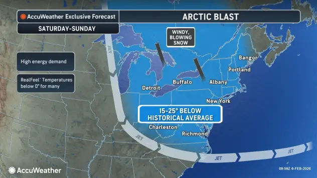
As an arctic blast of air approaches the Buffalo-Niagara region for the weekend, widespread snow is expected Friday and Friday night as a weak low and an arctic cold front cross the region, with some of the snow potentially heavy later this evening.
A Winter Weather Advisory is posted for the Buffalo metro area and much of WNY through Saturday evening.
During the day Friday, snowfall will be very manageable.
"We're not expecting much impact for the snow," National Weather Service meteorologist Heather Kenyon tells WBEN. "Maybe an inch across the area through today, however the heavier snow is going to arrive tonight with the cold front."
Snowfall amounts of 2 to 4 inches are expected across much of the area from Friday afternoon through Friday night, with some higher amounts closer to 6 inches for the higher terrain near Lake Erie. The heaviest snowfall is expected in the 9 p.m. to 2 a.m. timeframe.
Winds will also be on the increase Friday, gusting to 30 mph, at times.
As the snow falls, temperatures will once again dive, with dangerously cold wind chills between 15 and 35 below zero expected this weekend.
A Cold Weather Advisory is posted for the Buffalo metro area through Sunday morning and an Extreme Cold Warning in posted for southern Erie County and the southern tier through Sunday morning as well.
Low temperatures will fall to near zero to the single digits below zero by sunrise Saturday. Little improvement is expected during the day with highs near zero to the single digits.
"We're expecting dangerous wind chills across the entire WNY region," Kenyon tells WBEN. "We're expecting wind chills between -25 to -30."
The combination of frigid temperatures and strong winds will create dangerous wind chills across the region. Wind chills as low as 30 below zero are expected to be felt across the higher terrain south of Buffalo.
While still very cold, wind chills will be slightly higher (15 to 24 below zero) across the Niagara Frontier and southern shore of Lake Ontario. Winds will diminish across the region later Saturday through Sunday which will allow wind chills to improve during the day, before dropping back down Saturday night.
"Really, the cold is going to continue through Saturday night and into Sunday," Kenyon cautions. "It's going to be a very cold weekend."
Any relief in sight?
Kenyon tells us we do remain on the cooler side through next week, but with some moderation, especially after this weekend.
"We are going to get 'warmer', with temperatures just slowly climbing up to near normal, which is about the freezing mark" Kenyon says.
WINTER WEATHER ADVISORY REMAINS IN EFFECT FROM 7 AM THIS MORNING TO 7 PM EST SATURDAY
* WHAT...A combination of widespread snow and localized lake effect snow expected. Total snow accumulations 3 to 6 inches expected, with locally higher amounts possible across the hilltops south of Buffalo. Winds gusting as high as 40 mph will create areas of blowing and drifting snow.
* WHERE...Erie, Niagara, Orleans, Genesee, Wyoming, Chautauqua, and Cattaraugus Counties.
* WHEN...From 7 AM this morning to 7 PM EST Saturday.
* IMPACTS...Travel will be difficult. The hazardous conditions will impact the Friday evening commute.
* ADDITIONAL DETAILS...An Arctic front will bring widespread snow showers to the region this morning, which will then taper off to more localized lake effect snow tonight through Saturday. Winds strengthening behind this front late this evening through Saturday will resulting of blowing and drifting of the fresh snowpack.
PRECAUTIONARY/PREPAREDNESS ACTIONS...
Periods of snow will result in snow covered roads and limited visibilities. Slow down and use caution while driving.
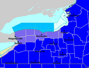
COLD WEATHER ADVISORY IN EFFECT FROM 1 AM SATURDAY TO 10 AM EST SUNDAY
* WHAT...Bitterly cold wind chills between 15 and 24 below zero expected. The coldest wind chills are expected to be late tonight into Saturday morning.
* WHERE...Niagara, Orleans, Monroe, Wayne, Northern Cayuga, Northern Erie, and Genesee Counties.
* WHEN...From 1 AM Saturday to 10 AM EST Sunday.
* IMPACTS...Bitterly cold wind chills as low as 24 below zero will cause frostbite on exposed skin in as little as 30 minutes.
PRECAUTIONARY/PREPAREDNESS ACTIONS...
This is a potentially hazardous situation to be outdoors. If you must be outside, be sure to cover all exposed skin. Frostbite can occur in 30 minutes or less with apparent temperatures of 15 below zero or colder.
EXTREME COLD WARNING IN EFFECT FROM 1 AM SATURDAY TO 10 AM EST SUNDAY
* WHAT...Dangerously cold wind chills as low as 30 below zero expected. The coldest wind chills are expected to be late tonight through Saturday.
* WHERE...Wyoming, Livingston, Ontario, Chautauqua, Cattaraugus, Allegany, and Southern Erie Counties.
* WHEN...From 1 AM Saturday to 10 AM EST Sunday.
* IMPACTS...Dangerously cold wind chills as low as 30 below zero will cause frostbite on exposed skin in as little as 15 minutes.
PRECAUTIONARY/PREPAREDNESS ACTIONS...
This is a potentially dangerous situation to be outdoors. If you must be outside, be sure to cover all exposed skin. Frostbite can occur in 15 minutes or less with apparent temperatures of 25 below zero or colder.