
A dangerously cold air mass is bringing bone-chilling cold to the Buffalo-Niagara region, and it will be followed-up with steady and heavy snowfall associated with a massive winter storm impacting much of the nation Sunday.
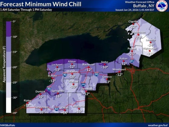
Temperatures near or below zero were commonplace early Saturday across the Western New York region, and wind chills were well into the sub-zero range.
"Wind chills -10 to -20 as we start off the day, then they'll slowly come up," National Weather Service meteorologist Jim Mitchell tells WBEN. "It's still going to remain very chilly...it's going to be a chilly day."
A Cold Weather Advisory remains posted through Saturday morning.
In the wake of the snow, frigid air will become the main theme for the start of the weekend.
In advance of the approaching large storm system, only light snow showers will begin to develop across the region late Saturday.
"The steady show will probably arrive here between mid to late morning tomorrow," Mitchell tells us. "Then it will pick up in intensity, the heaviest snow will fall from tomorrow afternoon, right through the first half of tomorrow night, then as we get toward Monday morning, the heavier snow will start to taper off."
A Winter Storm Warning is posted area-wide late Saturday into Monday.
As far as accumulations go, storm totals from Sunday through Monday evening will be in the 8 to 14 inch range for most of the area. Far WNY, including Buffalo, Niagara Falls, and the Lake Erie shore will likely be near the lower end of that range.
LISTEN: Fox News Weather Coverage
Lake Erie Ice Cover
There is a direct correlation between the amount of ice cover on Lake Erie and the potential for lake effect snow across the region. That ice cover has grown substantially this week, given the cold conditions.
"It was about 85% ice coverage at this point," Mitchell says. "But a lot of that ice offshore is very slushy and thin, so it's not impacting the response off the lake too much at this point." So, lake effect is still a possibility.
"But with these temperatures we've been talking about, and the winds are also going to die down as we go through tomorrow night into the weekend, that should allow the lake to solidly freeze up 100%...so that's really going to curb the lake effect."
Related

COLD WEATHER ADVISORY REMAINS IN EFFECT UNTIL 10 AM EST THIS MORNING
* WHAT...Bitterly cold wind chills as low as 15 to 20 below zero expected.
* WHERE...Niagara, Orleans, Northern Erie, and Genesee Counties.
* WHEN...Until 10 AM EST this morning.
* IMPACTS...Bitterly cold wind chills as low as 15 below zero will cause frostbite on exposed skin in as little as 30 minutes.
PRECAUTIONARY/PREPAREDNESS ACTIONS...
This is a potentially hazardous situation to be outdoors. If you must be outside, be sure to cover all exposed skin. Frostbite can occur in 30 minutes or less with apparent temperatures of 15 below zero or colder.
COLD WEATHER ADVISORY REMAINS IN EFFECT UNTIL 10 AM EST THIS MORNING
* WHAT...Bitterly cold wind chills as low as 20 to 25 below zero expected.
* WHERE...Southern Erie and Wyoming counties and the western Southern Tier.
* WHEN...Until 10 AM EST this morning.
* IMPACTS...Bitterly cold wind chills as low as 25 below zero will cause frostbite on exposed skin in as little as 30 minutes.
Frostbite and hypothermia will occur if unprotected skin is exposed to these temperatures.
PRECAUTIONARY/PREPAREDNESS ACTIONS...
This is a potentially hazardous situation to be outdoors. If you must be outside, be sure to cover all exposed skin. Frostbite can occur in 30 minutes or less with apparent temperatures of 15 below zero or colder.
Use caution while traveling outside. Wear appropriate clothing, a hat, and gloves.
Make frequent checks on older family, friends, and neighbors. Ensure portable heaters are used correctly. Do not use generators or grills inside.
WINTER STORM WARNING REMAINS IN EFFECT FROM 7 AM SUNDAY TO 7 PM EST MONDAY
* WHAT...Heavy snow expected. Total snow accumulations 8 to 14 inches.
* WHERE...Niagara, Northern Erie, and Genesee Counties.
* WHEN...From 7 AM Sunday to 7 PM EST Monday.
* IMPACTS...Travel will be very difficult. The hazardous conditions will impact the Monday morning commute.
PRECAUTIONARY/PREPAREDNESS ACTIONS...
Widespread accumulating snow will create dangerous travel conditions.
Submit snow reports through our website or social media.
Consider delaying travel. If you must travel, drive with extreme caution. Leave plenty of room between you and the motorist ahead of you, and allow extra time to reach your destination. Avoid sudden braking or acceleration, and be especially cautious on hills or when making turns.
WINTER STORM WARNING REMAINS IN EFFECT FROM 1 AM SUNDAY TO 7 PM EST MONDAY
* WHAT...Heavy snow expected. Total snow accumulations 8 to 14 inches.
* WHERE...Wyoming, Livingston, Ontario, Chautauqua, Cattaraugus, Allegany, and Southern Erie Counties.
* WHEN...From 1 AM Sunday to 7 PM EST Monday.
* IMPACTS...Travel will be very difficult. The hazardous conditions will impact the Monday morning commute.
PRECAUTIONARY/PREPAREDNESS ACTIONS...
Widespread accumulating snow will create dangerous travel conditions.
Submit snow reports through our website or social media.
Consider delaying travel. If you must travel, drive with extreme caution. Leave plenty of room between you and the motorist ahead of you, and allow extra time to reach your destination. Avoid sudden braking or acceleration, and be especially cautious on hills or when making turns.