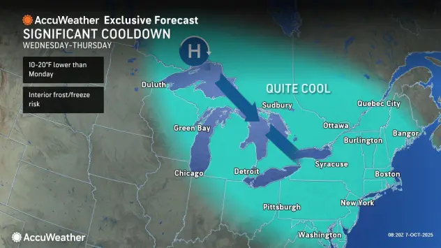

The dry, cool weather pattern that followed beneficial rainfall earlier in the work week will continue to be the main weather headline across the Buffalo-Niagara region into the weekend.
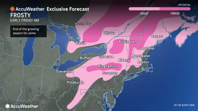
There will be widespread frost Thursday night through Friday morning, National Weather Service forecasters warn, with below freezing temperatures in some of the typical colder inland locations.
A Frost Advisory is posted for most of the Western New York region.
Despite plentiful sunshine Thursday, highs will only reach the mid 50's for lower elevations and around 50 on the highest hills in this cool airmass.
Below freezing temps are forecast for portions of the southern tier, and a Freeze Warning is posted for Cattaraugus and Allegany counties.
Temperatures will trend warmer into the weekend, with highs Friday in the low to mid 60's. It will be even warmer Saturday with mercury readings in the 60's everywhere, a few locations in the Genesee Valley may see temps in the low 70's.
Another frost may occur in some areas of the interior Northeast on Friday night, AccuWeather forecasters say, but the overall temperature trend should be slowly upward during the weekend.
"We have a gorgeous stretch of fall weather," Ask Andy meteorologist Andy Parker tells WBEN. "This is really going to change those leaves," Andy adds. "After tonight's frost, you're going to find that the colors are going to rapidly change across the landscape of Western New York."