
Buffalo, N.Y. (WBEN) - Here we go again!
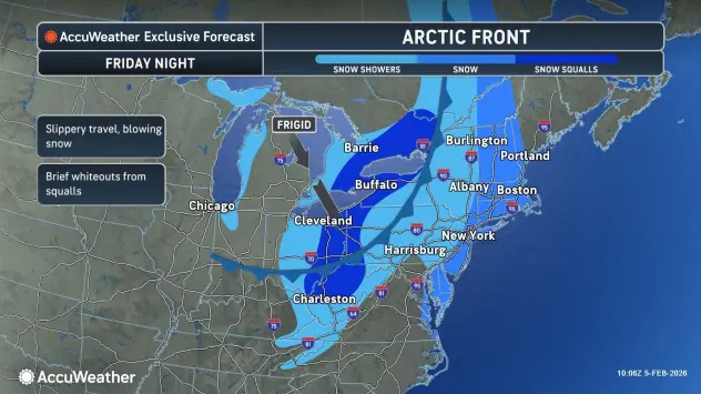
It's back to the deep freeze for the Buffalo-Niagara region for the upcoming weekend with dangerously cold temperatures and wind chill readings through the weekend after an arctic cold front blast into the region Friday night.
An Extreme Cold Watch is posted for the entire region from Friday night through Sunday morning.
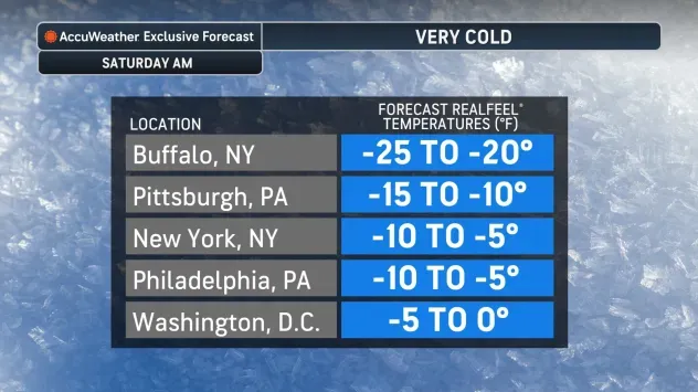
"Another round of very cold weather is going to appear this weekend," National Weather Service meteorologist Heather Kenyon tells WBEN. "It looks like dangerously cold wind chills as low as 25 below zero are possible, and this is across the entire Western New York region."
Temperatures will plummet overnight Friday into Saturday, nearing zero Saturday morning and will struggle to get through the single digits, and above zero across the higher terrain.
The arctic front will bring with it some pretty strong winds.
"The combination of the strong winds and the cold temperatures is what's going to produce those dangerously cold wind chills."
Along with the bitter cold, snow will add-in to the mix, leading to very wintry conditions across the region.
A Winter Weather Advisory is posted for the Buffalo metro area and most of WNY early Friday through Saturday evening.
Gusty winds and wrap around lake effect snow will develop behind the arctic cold front Friday night through Saturday night, with blowing and drifting of the fresh snow.
Total snow accumulations 3 to 6 inches expected, with locally higher amounts possible across the hilltops south of Buffalo.
EXTREME COLD WATCH IN EFFECT FROM LATE FRIDAY NIGHT THROUGH SUNDAY MORNING
* WHAT...Dangerously cold wind chills as low as 25 below zero possible. The coldest wind chills are expected to be late Friday night through Saturday.
* WHERE...Erie, Niagara, Orleans, Monroe, Wayne, Northern Cayuga, Genesee, Wyoming, Livingston, Ontario, Chautauqua, Cattaraugus, and Allegany Counties.
* WHEN...From late Friday night through Sunday morning.
* IMPACTS...Dangerously cold wind chills as low as 25 below zero could cause frostbite on exposed skin in as little as 15 minutes.
PRECAUTIONARY/PREPAREDNESS ACTIONS...
This is a potentially dangerous situation to be outdoors. If you must be outside, be sure to cover all exposed skin. Frostbite can occur in 15 minutes or less with apparent temperatures of 25 below zero or colder.
WINTER WEATHER ADVISORY IN EFFECT FROM 7 AM FRIDAY TO 7 PM EST SATURDAY
* WHAT...A combination of widespread snow and localized lake effect snow expected. Total snow accumulations 3 to 6 inches expected, with locally higher amounts possible across the hilltops south of Buffalo. Winds gusting as high as 40 mph will create areas of blowing and drifting snow.
* WHERE...Erie, Niagara, Orleans, Genesee, Wyoming, Chautauqua, and Cattaraugus Counties.
* WHEN...From 7 AM Friday to 7 PM EST Saturday.
* IMPACTS...Travel will be difficult. The hazardous conditions will impact the Friday evening commute.
* ADDITIONAL DETAILS...An Arctic front will bring widespread snow showers to the region Friday morning, which will then taper off to more localized lake effect snow Friday night through Saturday.
Winds strengthening behind this front late Friday evening through Saturday will resulting of blowing and drifting of the fresh snowpack.
PRECAUTIONARY/PREPAREDNESS ACTIONS...
Periods of snow will result in snow covered roads and limited visibilities. Slow down and use caution while driving.