
After an icy start Tuesday, the Western New York region will finally be in for a significant spring warmup.
A period of morning freezing rain will persist through midday across the southern tier portion of WNY Tuesday where a Winter Weather Advisory is posted for Chautauqua, Cattaraugus and Allegany counties through 4 p.m.
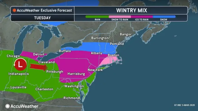
"Temperatures will eventually warm above freezing through the southern tier this afternoon," National Weather Service meteorologist Jon Hitchcock tells WBEN. "Up here in Buffalo, by time that rain gets here around midday or early afternoon, we'll already be above freezing, so no freezing rain issues for the metro area today.
Then, the warmup begins!
"This system marks the first day of a warmup that's going to have staying power," Hitchcock says. "Tomorrow we'll be mainly dry in the upper 40's, some rain on Thursday, but in the upper 40's again, Friday we're in the 50's and mainly dry, and those warm temperatures last all the way through the weekend, into a good part of next week."
WINTER WEATHER ADVISORY REMAINS IN EFFECT FROM 7 AM THIS MORNING TO 4 PM EST THIS AFTERNOON
* WHAT...Light freezing rain expected. Total ice accumulations less than one tenth of an inch.
* WHERE...The western Southern Tier.
* WHEN...From 7 AM this morning to 4 PM EST this afternoon. The greatest risk of freezing rain will be during the morning through midday hours.
* IMPACTS...A few slick spots are possible on untreated roads, sidewalks, and parking lots. The hazardous conditions may impact the Tuesday morning commute.
PRECAUTIONARY/PREPAREDNESS ACTIONS...
Periods of freezing rain may result in a few slick spots on untreated roads. Slow down and use caution while driving. Roads that appear to be just wet may in fact be icy.