Buffalo. N.Y. (WBEN) - Lake effect snow pummeled the Buffalo southtowns overnight into Tuesday morning, leading to near impossible driving conditions in some locations and numerous school districts making the decision to close Tuesday.
The scene in the southtowns is a stark contrast to the sunshine across the Buffalo metro area.
"That was a prolonged event, " said Meteorologist Andy Parker on WBEN. "Once that lake effect band locked in, it stayed and produced snowfall rates of 2 to 4 inches an hour. It set the stage for the snow to be measured in feet."
CHECK: WBEN Closings
A Winter Storm Warning remains posted for metro Buffalo and much of WNY, through Wednesday. A Cold Weather Advisory is posted for the southern tier as wind chills may reach 20 below zero.
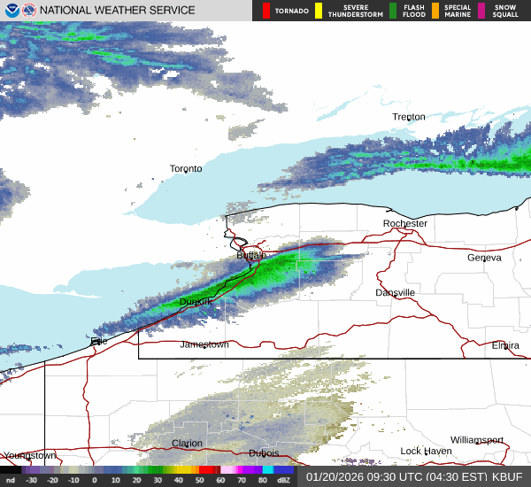
The lake effect snow band off Lake Erie was hovering between Dunkirk and Attica during much of the day Tuesday, with some slight oscillation north and southward.
The greatest snowfall amounts through today still looks to be across the Buffalo Southtowns (Hamburg, Orchard Park, and East Aurora) and southern Erie County, into western Wyoming County where additional snowfall amounts of up to a foot are possible today into this evening, pushing snowfall totals into the 2-3 foot range, especially in a narrow band from Evans/Angola to the more distant southern suburbs of Buffalo in central Erie County. Just outside of these areas, an additional 4-8 inches is possible, with 2-5 inches possible across from the City of Buffalo to the Buffalo Airport to Alden/Corfu...mainly late today into this evening.
Snow Totals
The town of Eden in southern Erie County was the bell ringer. 25.7 inches as of 7:30am. Colden picked up 22 inches. Hamburg, Orchard Park and East Aurora just over a foot of snow. At the northern edge, West Seneca reported 6 inches of snow.
Band on the move
The lake effect snow band will begin a trek northward across the Buffalo metro area during the day Tuesday, however the band will significantly weaken as it does.
"I think it's going to stay down in the Southern Tier until about 3pm or 4 pm and then it will begin to migrate back north," said Parker. "It won't be as fast as yesterday. We're looking at between 5 pm and 7 pm for it to return to the Buffalo Southtowns. The city of Buffalo will be a little later than that, arriving between 7pm and 9pm."
We're not done yet!
It's already cold, with wind chill readings in the negative single digits. But, it gets even colder later this week.
An arctic air mass again will impact the region late in the week, Meteorologist Jim Mitchell at the National Weather Service cautions.
"That's going to open the door to even colder air, it's going to be the coldest air of the season that we've seen so far," he says. "The heart of that will come in Friday and last through the weekend."
Stay tuned to NewsRadio 930 WBEN for the latest forecast details and check back here for the latest on-demand.
WINTER STORM WARNING REMAINS IN EFFECT UNTIL 4 PM EST WEDNESDAY
* WHAT...Heavy lake effect snow. Additional snow accumulations 10 to 18 inches in the most persistent bands. Winds gusting as high as 50 mph will produce significant blowing and drifting snow and near whiteouts at times. Snowfall rates may reach 2 to 3 inches per hour at times in the strongest lake effect snow bands.
* WHERE...Northern Erie and Genesee Counties. The greatest additional accumulations will be across the Buffalo Southtowns and southern Genesee County.
* WHEN...Until 4 PM EST Wednesday.
* IMPACTS...Whiteout conditions are expected and will make travel treacherous and potentially life-threatening. Roads, and especially bridges and overpasses, will likely become slick and hazardous. Travel will be very difficult. The hazardous conditions will impact the Monday evening and Tuesday morning commutes.
PRECAUTIONARY/PREPAREDNESS ACTIONS...
Heavy lake effect snow will create dangerous travel conditions.
WINTER STORM WARNING REMAINS IN EFFECT UNTIL 3 PM EST WEDNESDAY
* WHAT...Heavy lake effect snow. Additional snow accumulations 12 to 20 inches, with localized amounts of 2 to 3 feet across southwest and central Erie County in the most persistent bands. Winds gusting as high as 45 mph will produce significant lake effect snow and near whiteouts at times. Snowfall rates of 2 to 3 inches per hour in the most intense band.
* WHERE...Wyoming, Chautauqua, Cattaraugus, and Southern Erie Counties. Greatest snow accumulation across central and southern Erie County, western Wyoming County, extreme northern Chautauqua County, and extreme northwest Cattaraugus County.
* WHEN...Until 3 PM EST Wednesday.
* IMPACTS...Whiteout conditions are expected and will make travel treacherous and potentially life-threatening. Travel will be very difficult in deep snow covered roads. Areas of blowing snow will significantly reduce visibility. The hazardous conditions will impact the Monday evening through the Wednesday morning commutes.
Gusty winds will down tree branches and cause isolated power outages.
PRECAUTIONARY/PREPAREDNESS ACTIONS...
Widespread accumulating snow will create dangerous travel conditions.
COLD WEATHER ADVISORY REMAINS IN EFFECT FROM 10 PM THIS EVENING TO 1 PM EST TUESDAY
* WHAT...Bitterly cold wind chills as low as 20 below zero possible.
* WHERE...Wyoming, Chautauqua, Cattaraugus, and Allegany Counties.
* WHEN...From 10 PM this evening to 1 PM EST Tuesday.
* IMPACTS...Bitterly cold wind chills as low as 20 below zero will cause frostbite on exposed skin in as little as 30 minutes.
PRECAUTIONARY/PREPAREDNESS ACTIONS...
This is a potentially hazardous situation to be outdoors. If you must be outside, be sure to cover all exposed skin. Frostbite can occur in 30 minutes or less with apparent temperatures of 15 below zero or colder.