Buffalo, N.Y. (WBEN) - Lake effect snow bands are targeting the southtowns and southern tier Sunday, with a Lake Effect Snow Warning posted for southern Erie County through midday with the potential for 3 to 6 inches of additional snow accumulation.
A Winter Weather Advisory remains in place for the southern tier counties as well as Wyoming County through 1pm Sunday with an additional 2 to 4 inches of accumulation possible.
"We don't really have much of a break," says National Weather Service meteorologist Heather Kenyon who tells WBEN snow will again be in the weather picture this coming week. "It looks like we're going to see a widespread light snowfall starting Monday afternoon into Monday night." Kenyon expects a couple inches of accumulation from that general system.
Below normal temperatures are forecast through the coming work week.
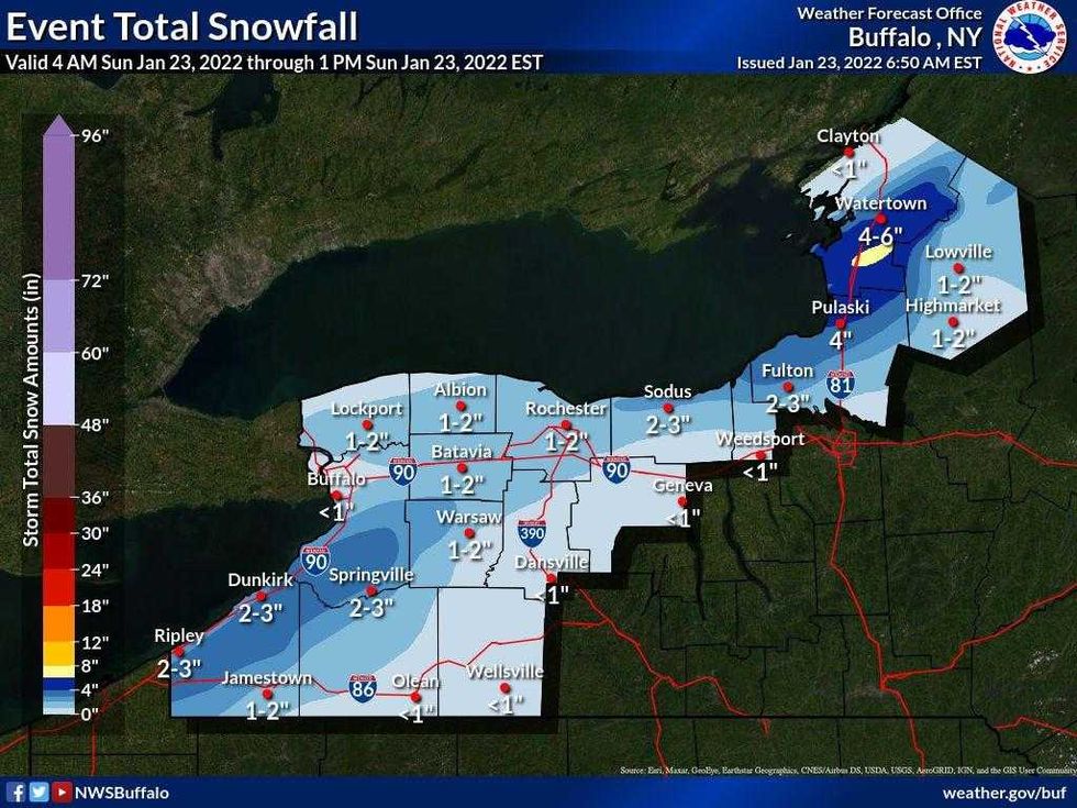 Snow forecast from NOAA Buffalo
LAKE EFFECT SNOW WARNING IN EFFECT UNTIL NOON EST TODAY
* WHAT...Heavy lake effect snow. Additional snow accumulations of 4 to 6 inches in the most persistent lake snows.
* WHERE...Southern Erie county.
* WHEN...Until noon EST today.
* IMPACTS...Plan on slippery road conditions.
PRECAUTIONARY/PREPAREDNESS ACTIONS...
Heavy snow will fall in relatively narrow bands. If traveling, be prepared for rapidly changing road conditions and visibilities.
WINTER WEATHER ADVISORY REMAINS IN EFFECT UNTIL 1 PM EST THIS AFTERNOON
* WHAT...Lake effect snow. Additional snow accumulations of 2 to 4 inches in the most persistent lake snows.
* WHERE...Chautauqua and Cattaraugus counties.
* WHEN...Until 1 PM EST this afternoon.
* IMPACTS...Plan on slippery road conditions.
PRECAUTIONARY/PREPAREDNESS ACTIONS...
Lake effect snow will fall in relatively narrow bands. If traveling, be prepared for rapidly changing road conditions and visibilities.