
Buffalo. N.Y. (WBEN) - As advertised, a long-lasting lake effect snow system is brewing across the Western New York region, targeting the Buffalo metro area and areas to the north first, before settling southward across the southtowns and southern tier Monday afternoon.
CHECK: WBEN Closings
A Winter Storm Warning has been posted for ALL of WNY, with the exception of Allegany County, through Wednesday.
After initially targeting the far northern portions of Erie County and Niagara County, the lake snow will then target the more populated metro area.
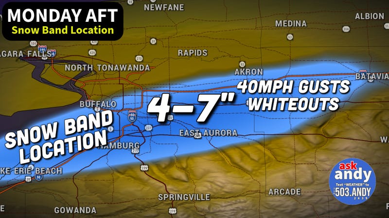
"We'll start to see the lake snow drift southward across the metro area this afternoon," National Weather Service meteorologist Tony Ansuini tells WBEN. "We're expecting about 4 to 7 inches of snow for the metro area, including the City of Buffalo."
The southtowns will be the main target of the lake effect bands later Monday, forecasters predict.
"That lake snows will settle into the southtowns tonight and Tuesday," Ansuini says. "This is where we'll see the heaviest snow, we'll probably see, locally, 1 to 2 feet down there."
The main strip of greatest snowfall amounts looks to be across the Buffalo Southtowns (Hamburg, Orchard Park, and East Aurora) into NW Wyoming County where snow amounts may approach 2 feet. Outside of these areas, a solid 6 to 12 inches is possible for far northern and southern Erie County and extreme northwest Chautauqua and Cattaraugus counties. A localized strip of 6 to 12 inches of snow will also be possible across Grand Island and Niagara Falls northeast into Niagara County where morning snow may be intense before the band shifts south.
Snowfall rates of up to 2 inches per hour will be possible at times with this lake effect band, including as it drops south across the Buffalo metro area and far northern Erie County on Monday morning.
'Ask Andy' meteorologist Andy parker tells WBEN, "For the northtowns, this is a very manageable situation." Parker says 4 to 7 inches across the most populated areas will be what to mainly expect. "I don't think the city is the center point of this at all."
The traditional southtowns snowbelt will be the target late Monday and into Tuesday with the potential for 1 to 2 feet of accumulation.
As for what to expect Tuesday and possible school closures resulting from the weather? "I would expect to see some school closings, especially in the southtowns," Parkers says.
The more intense lake effect snow band is expected to begin to dissipate late Tuesday into Wednesday.

Windy and Cold
As problematic as the snow will be the gusty winds and cold temperatures, forecasters caution.
"Very windy today, especially this(Monday) afternoon," Ansuini says. "The winds may actually be more impactful than the actual snowfall amounts."
Wind gusts of 40 to 50 mph will cause very hazardous and difficult driving conditions whit whiteout conditions at times.
And then there is the frigid cold temperatures that are hunkering down with the weather systen.
"Dangerously cold tonight, especially tonight," Ansuini emphasizes. "Wind chills of 10 below, to 20 below zero, with the coldest wind chills probably across the western southern tier."
Related

We're not done yet!
"It looks like we have even colder air that's going to settle in for the end fo the week and into the weekend," Ansuini cautions. "Looking for daytime highs only in the teens at best, and overnight low temperatures of zero or even colder."
Stay tuned to NewsRadio 930 WBEN for the latest forecast details and check back here for the latest on-demand.
WINTER STORM WARNING REMAINS IN EFFECT UNTIL 4 PM EST WEDNESDAY
* WHAT...Heavy snow and blowing snow expected. Total snow accumulations 10 to 20 inches. Winds gusting as high as 50 mph creating blowing and drifting snow and at times white out conditions.
* WHERE...Niagara, Orleans, Northern Erie, and Genesee Counties.
Greatest snow accumulation will be found across southern Niagara, southwestern Orleans, northern Erie and western Genesee counties.
* WHEN...Now to 4 PM EST Wednesday. Significant snow accumulation will occur late tonight through Monday, and again Tuesday into Tuesday night.
* IMPACTS...Whiteout conditions are expected and will make travel treacherous and potentially life-threatening. Travel will be very difficult in deep snow covered roads. The hazardous conditions will impact the Monday morning through the Wednesday morning commutes. Gusty winds will down tree branches and cause isolated power outages.
* ADDITIONAL DETAILS...Expect snowband oscillate with varying intensities and snowfall amounts over the area. Snowfall rates 2 inches per hour late tonight through Monday, and again Tuesday through Tuesday evening. Wind chill values zero to 10 below zero Monday night through Tuesday night.
PRECAUTIONARY/PREPAREDNESS ACTIONS...
Widespread accumulating snow will create dangerous travel conditions.
WINTER STORM WARNING REMAINS IN EFFECT FROM 7 AM THIS MORNING TO 3 PM EST WEDNESDAY
* WHAT...Heavy snow and blowing snow expected. Total snow accumulations 1 to 2 feet. Winds gusting as high as 50 mph creating blowing and drifting snow and at times white out conditions.
* WHERE...Wyoming, Chautauqua, Cattaraugus, and Southern Erie Counties. Greatest snow accumulation across the northern Chautauqua Ridge, Boston Hills and Buffalo Southtowns.
* WHEN...From 7 AM this morning to 3 PM EST Wednesday.
* IMPACTS...Whiteout conditions are expected and will make travel treacherous and potentially life-threatening. Travel will be very difficult in deep snow covered roads. Areas of blowing snow will significantly reduce visibility. The hazardous conditions will impact the Monday evening through the Wednesday morning commutes.
Gusty winds will down tree branches and cause isolated power outages.
* ADDITIONAL DETAILS...Expect lake snowband to oscillate with varying intensities and snowfall amounts over the area. Snowfall rates 2 inches per hour Monday afternoon through Tuesday morning.
Wind chill values five to 15 below zero Monday night through Tuesday night.
PRECAUTIONARY/PREPAREDNESS ACTIONS...
Widespread accumulating snow will create dangerous travel conditions.