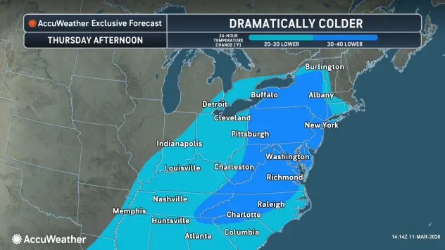

A return to winter conditions across the Buffalo-Niagara region for the foreseeable future as a colder weather pattern takes hold.
Much cooler weather is expected Thursday with temperatures in the 20's to low 30's early in the day, and highs in the low to mid 30's for the afternoon.
There will even be a few snow showers in the air Thursday across the Western New York region. "Little to no accumulation expected," National Weather Service meteorologist Jim Mitchell tells WBEN.
Chances for snow continue into Friday with any accumulation less than an inch across the entire region.
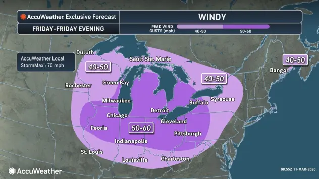
Heading into the weekend, the wind will be the weather headline.
"We will be pretty windy," Mitchell says of Friday. "Winds will increase through the day and we could see gusts of 40 to 50 mph by afternoon."
The weather for the upcoming weekend and two St. Patrick's Day parades will feel more like February than March.
Saturday should be dry, but cold and windy with high temperatures in the low to mid 30's.
Late Saturday into Sunday, it gets a bit more wintry. "It looks like an area of snow moving in, it's going to be wet snow," Mitchell says. Temperatures will actually rise a bit into Sunday morning and that snow will transition into possibly a cold rain before ending Sunday morning.
Sunday high temperatures will rise to around 45 degrees.
After our flirting with temperatures in the 60's recently, it all feels so cruel, but it really is par for the season, according to Mitchell.
"Our average high right now is in the lower 40's, so we're staying just a little bit below and a little bit above for the next several days."