
Buffalo. N.Y. (WBEN) - A blanket of fresh snow and bitter cold temperatures have overtaken the weather across the Buffalo-Niagara region, slowing travel and closing many school districts.
CHECK: WBEN CLOSINGS
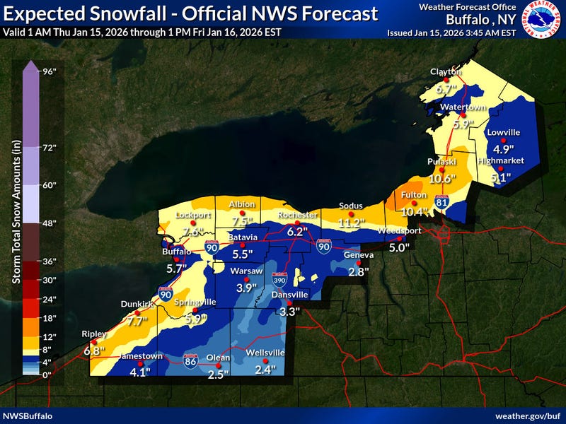
Winter Storm Warnings are posted for the region through Thursday, with additional snowfall in the forecast and lake effect snow expected to develop both north and south of the Buffalo metro region.
The snow will continue to fall through the day Thursday, adding to accumulations.
"For the metro area, probably looking at about an additional 2 to 4 inches," National Weather Service meteorologist Tony Ansuini tells WBEN. "Then we'll transition over to some lake effect snow...mainly north of the metro area, and also south of the metro area."
Once the general snowfall subsides across the general Western New York area, the lake effect snow will begin to setup, however the metro area will escape the bullseye of that, Ansuini says. "It should focus across Niagara and Orleans counties off Lake Ontario, and then off Lake Erie, most of the snow will be confined to the hills and the southern tier."
"Tomorrow morning's commute will probably be pretty tricky," Reynolds notes. "The system will just be pulling through here, and it will also be turning quite cold behind it, so any untreated roadways might become slippery."
Accumulations will be heavier well to the south of Buffalo. "Once the colder air comes in here, we will have some lake effect," Reynolds cautions. "Typical places south of Buffalo, across the Chautauqua Ridge and ski country will probably receive a little bit more, up to 10 inches are possible across those areas."
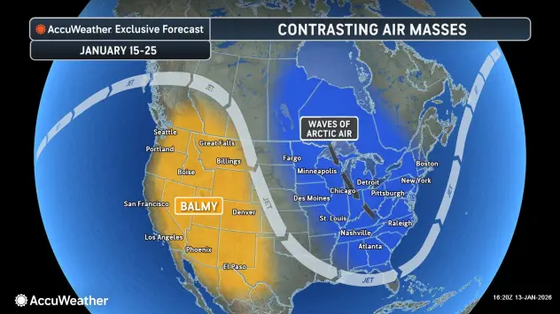
It's not just the snow that is thrusting the region into a more January-like forecast, it's the bitter cold temperatures.
Arctic air will move into the region today and tonight. Temperatures will fall to the teens and lower 20's this morning and remain steady through the day. Wind chill values will be near zero Thursday, forecasters say.
A brief break in the arctic air is in the weekend forecast, before temperatures again take a dive beginning Sunday.
The cold temperatures and active weather looks to continue for a while with just a few breaks of near normal temperatures values for a day or two at a time through late next week.
WINTER STORM WARNING IN EFFECT FROM 4 PM THIS AFTERNOON TO 7 PM EST THURSDAY...
* WHAT...Heavy snow expected. Total snow accumulations 5 to 10 inches. The greatest accumulation will be across northern Niagara and Orleans counties.
* WHERE...Niagara, Orleans, Northern Erie, and Genesee Counties.
* WHEN...From 4 PM this afternoon to 7 PM EST Thursday.
* IMPACTS...Travel will be difficult. The hazardous conditions will impact the Wednesday evening and Thursday morning commutes.
PRECAUTIONARY/PREPAREDNESS ACTIONS...
Widespread accumulating snow will create dangerous travel conditions.
WINTER STORM WARNING IN EFFECT UNTIL 1 AM EST FRIDAY
* WHAT...Heavy snow. Additional snow accumulations 6 to 12 inches.
The highest amounts will be across the Chautauqua Ridge and Boston Hills. Wind chills below zero are expected Thursday and Thursday night.
* WHERE...Wyoming, Chautauqua, Cattaraugus, and Southern Erie Counties.
* WHEN...Until 1 AM EST Friday.
* IMPACTS...Travel will be difficult. The hazardous conditions will impact the Wednesday evening and Thursday morning commutes.
PRECAUTIONARY/PREPAREDNESS ACTIONS...
Widespread accumulating snow will create dangerous travel conditions.