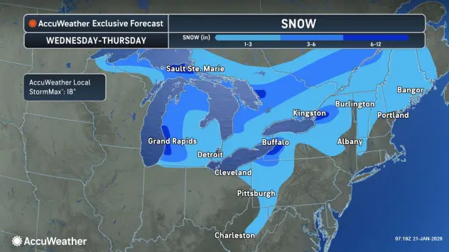

A general snowfall across all of Western New York is in the Wednesday forecast, with a Winter Weather Advisory posted for the entire region from midday Wednesday through early Thursday.
National Weather Service meteorologist Jim Mitchell tells WBEN a light and widespread snowfall will begin to fall area-wide Wednesday afternoon and into the evening. "Not a heavy snow, not real heavy snow rates by any means, but we could see a couple inches this afternoon, and that will impact the evening commute," Mitchell notes.
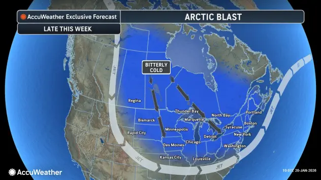
The next weather story after the general snow will be the extreme cold.
"We're going to see a little bit of a reprieve," Mitchell says, with daytime temperatures Wednesday and Thursday in the upper 20's to low 30's.
The more seasonal temperatures will then be followed-up by the coldest air of the season for the upcoming weekend. "We'll see some dangerous wind chills from Friday, right through Saturday, and possibly Sunday," Mitchell warns.
It will be windy Thursday and Friday as well, with gusts in the 30 to 50 mph range possible, contributing to impactful wind chills.
Weekend daytime highs will largely be in the single digits, and overnight lows around or slightly below zero both Friday and Saturday nights, forecasters say, with Cold Weather Advisories likely to be posted.
Lake Erie Ice
While lake effect snow can still occur with increased ice cover across Lake Erie, it does substantially reduce the impact of the weather phenomenon.
The colder temperatures this week have seen the ice cover blossom from a mere 5% coverage to 50% coverage in a matter of days. "With these cold temps that are coming, we'll probably see most of the lake probably froze over as we go into the weekend," Mitchell predicts.
Snow Totals
This week's lake effect snow produce some impressive snow totals in areas across the Buffalo southtowns.
"Down around Eden we saw around two feet," Mitchell says. North Tonawanda and parts of Niagara County saw 6 to 12 inch totals, with the least amount of snow accumulating across the City of Buffalo and over to the Buffalo Airport, with a couple inches on average. "Eden, Colden, those areas, anywhere from one-and-a-half to two feet, and some places, two-and-a-half feet."
WINTER WEATHER ADVISORY IN EFFECT FROM NOON TODAY TO 7 AM EST THURSDAY
* WHAT...Snow expected. Total snow accumulations 2 to 5 inches.
Winds gusting as high as 35 mph will cause blowing and drifting snow.
* WHERE...All of western New York.
* WHEN...From noon today to 7 AM EST Thursday.
* IMPACTS...Plan on slippery road conditions. The hazardous conditions will impact the Wednesday evening and Thursday morning commutes.
PRECAUTIONARY/PREPAREDNESS ACTIONS...
Periods of snow will result in snow covered roads and limited visibilities. Slow down and use caution while driving.