
Buffalo, N.Y. (WBEN) - Right on cue during the early hours of Monday morning, a wall of wind rushed into the Buffalo-Niagara region, ushering in a march of colder air and the setup for a long term lake effect snow event across much of the region.
Already, wind gusts in the 55 mph range have been recorded and gusts to 65 mph are forecast through the day, National Weather Service forecasters say. "Although there is expected to be a window, between the late morning and the afternoon hours, where we could see wind gusts up to 75 mph northeast of Lake Erie," NWS meteorologist Phillip Pandolfo tells WBEN.
The center of the strongest wind potential looks to be around 11 a.m. Monday, with a very rapid ramp-up in winds from roughly 8 a.m. to that time.
Winds will subside somewhat late Monday and into Tuesday, however Pandolfo notes it will remain gusty Tuesday with winds in the 40 mph range.
A laundry list of warnings and advisories are in place across the entire region Monday, including:
-Winter Weather Advisory for the Buffalo-Niagara region
-Winter Storm Warning for southern Erie, southern tier.
-High Wind Warning for all of WNY
-Lakeshore Flood Warning for the Lake Erie shoreline
-Flood Watch for the entire region
Lake Effect Snow
Initially, winds will be southwesterly, which will likely cause the lake effect snow bands to form over the Niagara Frontier in the afternoon. The lake snow is expected to develop during the late morning and early afternoon hours, Pandolfo says, with some uncertainty as to how intense the snow will be across the Buffalo metro area initially.
"With the combination of the winds, we could be looking at a pretty nasty stretch of weather, but only for a few hours across the Buffalo metro area," Pandolfo notes.
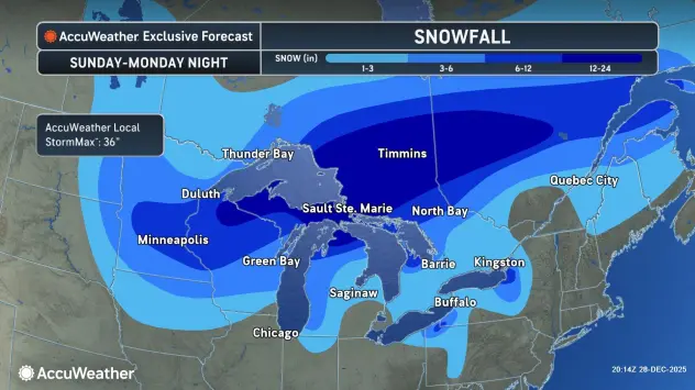
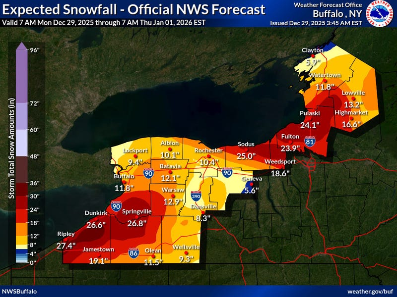
The initial forecast calls for 3 to 6 inches of snow across the Buffalo metro, however with the strong winds blowing the snow, any falling snow combined with the wind could cause whiteout conditions at times.
Winds are expected to shift relatively quickly to westerly and then northwesterly through Monday night, which would place the greatest snowfall accumulations by Tuesday morning off Lake Erie south of Buffalo, into the southtowns and across the ski country.
The snow band will shift southward and south of the southtowns quickly late Monday, and remain a factor in the forecast there through the entire week.
"We are expecting lake effect snow every single period, through at least Thursday, likely into Friday and beyond," Pandolfo predicts.
Lake Seiche Possible
While our region has had several lake seiches recently to just over 6 feet, a much stronger wind flow is expected to bring a seiche on Lake Erie, potentially to warning levels (8 or 9feet). A Lakeshore Flood Warning has been issued to account for this potential. One factor that may back it tough for lake level rises is the lake level is currently below normal. But given the strength of this system, even the low lake level will still have potential for exceeding warning level. Flooding is possible along Route 5 in Hamburg, Buffalo Harbor and Canalside, Dunkirk Harbor, and other flood prone locations. Flooding could along occur along portions of the Niagara River. Very high wave action may also result in significant shoreline erosion.
HIGH WIND WARNING REMAINS IN EFFECT FROM 4 AM MONDAY TO 1 AM EST TUESDAY
* WHAT...Southwest winds 35 to 45 mph with gusts up to 75 mph expected. The strongest wind gusts will be along the Lake Erie shoreline and near Downtown Buffalo.
* WHERE...Erie, Niagara, Orleans, Monroe, Genesee, Wyoming, and Chautauqua Counties.
* WHEN...From 4 AM Monday to 1 AM EST Tuesday.
* IMPACTS...Damaging winds will blow down trees and power lines.
Widespread power outages are expected. Shallow rooted trees in a saturated ground will be more susceptible to falling. Travel will be extremely difficult, especially for high profile vehicles.
PRECAUTIONARY/PREPAREDNESS ACTIONS...
Avoid being outside in forested areas and around trees. If possible, remain in the lower levels of your home during the windstorm, and avoid windows. Use caution if you must drive.
WINTER WEATHER ADVISORY REMAINS IN EFFECT FROM 10 AM THIS MORNING TO 10 PM EST THIS EVENING
* WHAT...Snow and blowing snow expected. Total snow accumulations 2 to 5 inches in the most persistent lake snows. Winds gusting as high as 75 mph.
* WHERE...Northern Erie and Genesee Counties.
* WHEN...From 10 AM this morning to 10 PM EST this evening.
* IMPACTS...Plan on slippery road conditions and brief periods of whiteout conditions. Areas of blowing snow will significantly reduce visibility. The hazardous conditions will impact the evening commute tonight.
PRECAUTIONARY/PREPAREDNESS ACTIONS...
Periods of snow will result in snow covered roads and limited visibilities. Slow down and use caution while driving.
During lake effect snow, the weather can vary from bands of locally heavy snow with greatly reduced visibilities to dry conditions just a few miles away. Be prepared for rapid changes in weather, visibility, and road conditions.
WINTER STORM WARNING REMAINS IN EFFECT FROM 1 PM THIS AFTERNOON TO 1 AM EST FRIDAY
* WHAT...Heavy snow expected. Total snow accumulations 1 to 3 feet.
Winds gusting as high as 65 mph creating blowing and drifting snow and whiteout conditions.
* WHERE...Wyoming, Chautauqua, Cattaraugus, and Southern Erie Counties.
* WHEN...From 1 PM this afternoon to 1 AM EST Friday.
* IMPACTS...Whiteout conditions are expected and will make travel treacherous and potentially life-threatening. Travel will be very difficult. The hazardous conditions will impact travel through the week.
* ADDITIONAL DETAILS...Lake effect snow is expected oscillate several times downwind of Lake Erie this week. Forecast snowfall amounts could be much higher where lake bands persist during this long duration event. The strongest winds will be today and tonight.
PRECAUTIONARY/PREPAREDNESS ACTIONS...
Widespread accumulating snow will create dangerous travel conditions.
LAKESHORE FLOOD WARNING REMAINS IN EFFECT FROM 5 AM EARLY THIS MORNING TO 10 PM EST THIS EVENING
* WHAT...Significant lakeshore flooding expected.
* WHERE...Niagara, Erie, and Chautauqua counties.
* WHEN...From 5 AM early this morning to 10 PM EST this evening.
* IMPACTS...The rapid rise in water levels will result in lakeshore flooding along the Lake Erie and Upper Niagara River shores. Along the Lake Erie shore, flooding is likely along Route 5 in Hamburg, Buffalo Harbor and Canalside, Dunkirk Harbor, and other flood prone locations. Along the Upper Niagara River, flooding is likely to affect Grand Island and Cayuga Island. Very high wave action will also result in significant shoreline erosion.
PRECAUTIONARY/PREPAREDNESS ACTIONS...
A Lakeshore Flood Warning means lakeshore flooding is occurring, is imminent, or is expected to occur. For your safety, stay off breakwaters, piers, rock outcroppings and beaches! Waves are often larger than they appear and can easily wash you away.
Expect significant beach erosion and debris, local road closures and extremely dangerous boating conditions.
FLOOD WATCH REMAINS IN EFFECT THROUGH THIS AFTERNOON
* WHAT...Flooding caused by excessive rainfall continues to be possible.
* WHERE...A portion of western New York, including the following counties, Allegany, Cattaraugus, Chautauqua, Genesee, Niagara, Northern Erie, Orleans, Southern Erie and Wyoming.
* WHEN...Through this afternoon.
* IMPACTS...Excessive runoff may result in flooding of rivers, creeks, streams, and other low-lying and flood-prone locations.
The greatest threat for flooding will be along the Buffalo area creeks and rivers. Flooding may occur in poor drainage and urban areas.
* ADDITIONAL DETAILS...
- Rainfall has averaged between 0.50-1.5" in the watch area.
Additional rainfall will average a quarter to a third of an inch. Runoff will continue this morning, but will sharply slow as colder temperatures move into the area.
- http://www.weather.gov/safety/flood PRECAUTIONARY/PREPAREDNESS ACTIONS...
You should monitor later forecasts and be alert for possible Flood Warnings. Those living in areas prone to flooding should be prepared to take action should flooding develop.
Related
