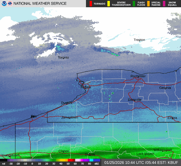

A massive winter storm that is impacting a majority of the US will be making its presence known across all of Western New York with widespread heavy snow expected Sunday through Sunday night, and finally tapering off Monday morning.
CHECK: WBEN Closings
The bulk of the heaviest snow will fall from late this morning through tonight across the area, with moderate lake enhanced snow continuing across the higher terrain east of Lake Erie through the day Monday.
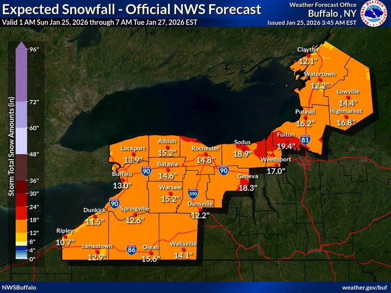
When all is said and done, expect total snowfall amounts ranging from 9 to 18 inches. The highest amounts will be across the higher terrain of the interior Southern Tier.
"We're looking for a total accumulation of 9 to 15 inches by the time it's over Monday morning," National Weather Service meteorologist Dan Kelly tells WBEN. "The heaviest amounts are expected this afternoon(Sunday) and into this evening."

The bulk of the significant snowstorm will already be over before daybreak Monday, with lesser intensity wrap around snow and lake enhancement lingering through the day.
Additional snow accumulations Monday will be minor, generally just 1 to 2 inches in most areas, with some spotty 3 inch amounts in lake enhancement areas. Northwest winds will increase some in the afternoon with gusts in the 20-30 mph range, producing some limited blowing and drifting in open areas.
A Winter Strom Warning remains posted for ALL of WNY through Monday.
In the wake of the snow, frigid air will again be the norm for much of the coming work week.
NWS forecasters are predicting well below normal temperatures through the end of the week. Maximum temperatures forecasted in the teens for highs the second half of the week, may match the beginning half of the week.
The last time we had a weeks worth of maximum temperatures in the teens or colder was the winter of 2017-18, late December into early January.
LISTEN: Fox News Weather Coverage
Lake Erie Ice Cover
There is a direct correlation between the amount of ice cover on Lake Erie and the potential for lake effect snow across the region. That ice cover has grown substantially this week, given the cold conditions.
"It was about 85% ice coverage at this point," Mitchell says. "But a lot of that ice offshore is very slushy and thin, so it's not impacting the response off the lake too much at this point." So, lake effect is still a possibility.
"But with these temperatures we've been talking about, and the winds are also going to die down as we go through tomorrow night into the weekend, that should allow the lake to solidly freeze up 100%...so that's really going to curb the lake effect."
Related

WINTER STORM WARNING REMAINS IN EFFECT FROM 7 AM THIS MORNING TO 7 PM EST MONDAY
* WHAT...Heavy snow expected. Total snow accumulations 9 to 15 inches. The highest amounts are expected along the Lake Ontario shore due to lake enhancement and across the higher terrain of southern Genesee County.
* WHERE...Niagara, Orleans, Northern Erie, and Genesee Counties.
* WHEN...From 7 AM this morning to 7 PM EST Monday.
* IMPACTS...Travel will be very difficult. The hazardous conditions will impact the Monday morning and evening commutes.
* ADDITIONAL DETAILS...The bulk of the heavy snow is expected from around midday through tonight, with heavy snow persisting along the southern shore of Lake Ontario Monday.
PRECAUTIONARY/PREPAREDNESS ACTIONS...
Widespread accumulating snow will create dangerous travel conditions.
Submit snow reports through our website or social media.
Consider delaying travel. If you must travel, drive with extreme caution. Leave plenty of room between you and the motorist ahead of you, and allow extra time to reach your destination. Avoid sudden braking or acceleration, and be especially cautious on hills or when making turns.
WINTER STORM WARNING REMAINS IN EFFECT UNTIL 7 PM EST MONDAY
* WHAT...Heavy snow expected. Total snow accumulations 12 to 18 inches. The highest amounts are expected across the higher terrain of the interior Southern Tier and Finger Lakes region.
* WHERE...Wyoming, Livingston, Ontario, Chautauqua, Cattaraugus, Allegany, and Southern Erie Counties.
* WHEN...Until 7 PM EST Monday.
* IMPACTS...Travel will be very difficult. The hazardous conditions will impact the Monday morning and evening commutes.
* ADDITIONAL DETAILS...The bulk of the heavy snow is expected late this morning through this evening. Moderate snow will continue across the higher terrain east of Lake Erie through Monday.
PRECAUTIONARY/PREPAREDNESS ACTIONS...
Widespread accumulating snow will create dangerous travel conditions.
Submit snow reports through our website or social media.
Consider delaying travel. If you must travel, drive with extreme caution. Leave plenty of room between you and the motorist ahead of you, and allow extra time to reach your destination. Avoid sudden braking or acceleration, and be especially cautious on hills or when making turns.