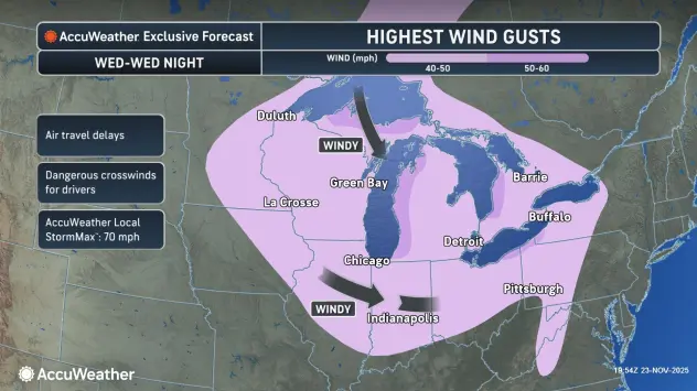

Forecasters are beginning to get a much better picture of the potential for lake effect snow impacting the Western New York region beginning late Wednesday and extending right into the Thanksgiving weekend.
A Winter Storm Watch has been posted for southern Erie, Wyoming, Cattaraugus and Chautauqua counties from 7 p.m. Wednesday through 7 p.m. Thanksgiving Day.
"It's going to be a very changeable week in terms of our weather," National Weather Service meteorologist Phillip Pandolfo tells WBEN.
Mild conditions will prevail through much of Wednesday, before a cold front rushes through and ushers in big changes.
"Temperatures will plummet, winds will pick up quite a bit and we'll see a transition over to snow," Pandolfo says. And the lake effect snow could be potentially heavy east of Lake Erie, lasting through Thanksgiving and into Friday as well.
While the main focus of the lake effect will ultimately be across the southern tier, everyone gets into the act at some point during this lake effect event.
"Between Wednesday, Thursday and Friday, we believe just about everywhere is going to see at least some amount of snow," Pandolfo predicts. "The heaviest accumulation should be confined well south of Buffalo, we're thinking even further south than the southtowns."
At this point of the forecast, it's still too soon to predict accumulations, but the Winter Storm Watch warns of greater than 7 inches of snow in the most persistent snow areas.
The wind will also play a factor, becoming noticeable Wednesday and then remaining in the forecast through Thanksgiving Day. "We could be looking at, in this main lake effect area, potentially whiteout conditions as well," Pandolfo says.
The lake effect will linger through Friday, and forecasters are already looking at another weather system that could reawaken lake effect later in the weekend. That system may be warmer and involve rain, however.
WINTER STORM WATCH IN EFFECT FROM WEDNESDAY EVENING THROUGH FRIDAY EVENING
* WHAT...Heavy lake effect snow possible. Total snow accumulations greater than 7 inches possible in the most persistent lake snows.
Winds could gust as high as 45 mph, producing blowing and drifting snow and possible whiteout conditions.
* WHERE...Wyoming, Chautauqua, Cattaraugus, and Southern Erie Counties.
* WHEN...From Wednesday evening through Friday evening.
* IMPACTS...Whiteout conditions are possible and may make travel treacherous and potentially life-threatening. Plan on slippery road conditions. The hazardous conditions could impact the busy Thanksgiving holiday travel period. Gusty winds could down tree branches and cause isolated power outages.
PRECAUTIONARY/PREPAREDNESS ACTIONS...
Narrow bands of heavy snow could bring rapidly changing road conditions and visibilities. Localized travel problems will be possible.