
Buffalo, N.Y (WBEN) - There may be more symbolism than substance in the wintry-like forecast for the Buffalo-Niagara and Western New York region for the next couple days, however, many will see a coating of white when all is said and done.
"Sunday, is when things get interesting," meteorologist Andy Parker tells WBEN.
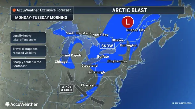
What Andy describes as a cold core low will make itself home over Western New York Sunday, with cold rain on one side of the system and a wet snow on the other.
"I'm expecting to see a rain event at the start(Sunday), temperatures that may be in the 40's...and then we'll kind of see the rain mix in with snow mixed with rain," Parker tells WBEN.
The lake effect may play a trick on areas north of the Buffalo metro Sunday as well, Parker cautions, with slightly colder temperatures closer to Lake Ontario.
"It may be cool enough that we start mixing in wet snowflakes and have a slushy accumulation in Niagara and Orleans counties during the day on Sunday," Parker says, with areas in the southern tier remaining wet much of Sunday.
The National Weather Service has posted a Winter Weather Advisory for Niagara and Orleans counties from 10 a.m. Sunday until 7 a.m. Monday and for Chautauqua County from 7 p.m. Sunday through 1 p.m. Monday.
As for accumulations Sunday?
"It would not be surprising for some areas to pick up a slushy accumulation by Monday morning."
Lake Effect Switch Flips Monday
In a nutshell, beginning Monday, Parker tells us, "We've got two days that will be as January as anything else."
Temperatures Monday and Tuesday will be in the 30's with a gusty wind and the lake effect switch will flip to the 'on' position, Parker cautions.
But where will the lake effect take aim?
The wind will generally be from the northwest, Parker says, targeting the less populated areas to the south.
"This takes that big fire hose of snow off Lake Erie toward the City of Buffalo, that's off the table."
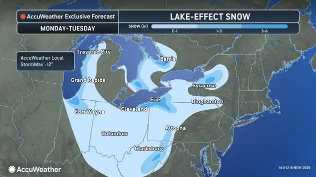
Given the direction of the wind, the lake effect will only have the north to south shorter fetch of Lake Erie to generate less intense bands of lake effect snow. "That generally allows the Chautauqua Ridge, areas of Chautauqua County, Erie, Pennsylvania does well on this one, Mayville, Bemus Point...those spots are going to see the accumulation(Monday-Tuesday)."
While there will be several inches of accumulation well south south of the city, it will be more of a nuisance type lake effect event for metro Buffalo, Parker assures. And, any snow that does fall, will stick around due to the colder temperatures.
But fear not, when it comes to cleaning up the yard for fall.
"If you didn't get your leaves raked up, don't worry...you're going to see your grass again....this will melt-off by Wednesday."
COLD!
As for temperatures, National Weather Service forecasters say we can expect the coldest night of the season so far Monday night when lows will range from the upper teens across the interior of the Southern Tier, to the lower-mid 20s elsewhere. Highs will range through the 30's Tuesday, and lows in the mid 20's to lower 30's Tuesday night.
WINTER WEATHER ADVISORY IN EFFECT FROM 10 AM THIS MORNING TO 7 AM EST MONDAY
* WHAT...Rain changing over to wet snow expected. Total snow accumulations 3 to 5 inches.
* WHERE...Niagara and Orleans Counties.
* WHEN...From 10 AM this morning to 7 AM EST Monday.
* IMPACTS...Plan on slippery road conditions. The hazardous conditions will impact the Monday morning commute.
* ADDITIONAL DETAILS...The majority of snow accumulations through this afternoon will be on grassy and elevated surfaces, though snow intensity may be sufficient to result in snow covered roads at times.
WINTER WEATHER ADVISORY IN EFFECT FROM 7 PM THIS EVENING TO 1 PM EST MONDAY
* WHAT...Snow expected. Total snow accumulations 3 to 6 inches.
* WHERE...Chautauqua County.
* WHEN...From 7 PM this evening to 1 PM EST Monday.
* IMPACTS...Travel will be difficult. The hazardous conditions will impact the Monday morning commute.
* ADDITIONAL DETAILS...The highest snowfall accumulations will be found across the Chautauqua Ridge.
PRECAUTIONARY/PREPAREDNESS ACTIONS...
Periods of snow will result in snow covered roads and limited visibilities. Slow down and use caution while driving.