
Another round of winter weather will impact the Buffalo metro area late Wednesday and early Thursday, again impacting the morning drivetime.
A pair of strong cold fronts will cross the region Wednesday night through early Thursday, bringing snow showers and bands of locally heavier lake enhanced snow.
The lake snows will start northeast of Lake Erie Wednesday evening near Buffalo, then move rapidly south late tonight through Thursday to areas southeast of the lake.
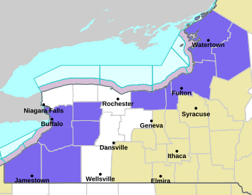
A Winter Weather Advisory is posted for the Buffalo metro area and northern Erie County Wednesday night and through 7 a.m. Thursday, while the advisory is posted through the entire day Thursday for southern Erie county and the southern tier.
The bands of snow will produce light to locally moderate snow accumulations, and gusty winds will also produce areas of blowing and drifting snow.
COLD AIR COMING
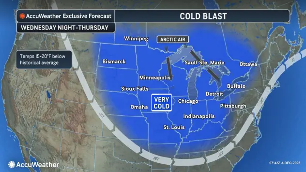
The coldest airmass of the winter season will arrive late Thursday through early Friday with wind chills dropping to at or below zero Thursday night through early Friday morning.
Mainly dry weather will return by Friday as high pressure briefly builds into the eastern Great Lakes.
WINTER WEATHER ADVISORY IN EFFECT FROM 7 PM THIS EVENING TO 6 AM EST THURSDAY
* WHAT...Lake effect snow expected. Total snow accumulations 2 to 4 inches in the most persistent lake snows. Winds gusting as high as 35 mph will produce blowing and drifting snow.
* WHERE...Northern Erie and Genesee Counties.
* WHEN...From 7 PM this evening to 6 AM EST Thursday.
* IMPACTS...Plan on snow covered and slippery road conditions with poor visibility. While snowfall amounts will be minor, much of the snow will fall in a brief, heavy burst.
PRECAUTIONARY/PREPAREDNESS ACTIONS...
Lake effect snow will fall in relatively narrow bands. If traveling, be prepared for rapidly changing road conditions and visibilities.
WINTER WEATHER ADVISORY IN EFFECT FROM MIDNIGHT TONIGHT TO 7 PM EST THURSDAY
* WHAT...Lake effect snow expected. Total snow accumulations 2 to 5 inches in the most persistent lake snows, with the greatest amounts across the Boston Hills and Chautauqua Ridge. Winds gusting as high as 35 mph will produce blowing and drifting snow.
* WHERE...Wyoming, Chautauqua, Cattaraugus, and Southern Erie Counties.
* WHEN...From midnight tonight to 7 PM EST Thursday.
* IMPACTS...Plan on snow covered and slippery road conditions with poor visibility. While snowfall amounts will be minor, much of the snow will fall in a brief, heavy burst. The hazardous conditions will impact the Thursday morning commute.
PRECAUTIONARY/PREPAREDNESS ACTIONS...
Lake effect snow will fall in relatively narrow bands. If traveling, be prepared for rapidly changing road conditions and visibilities.