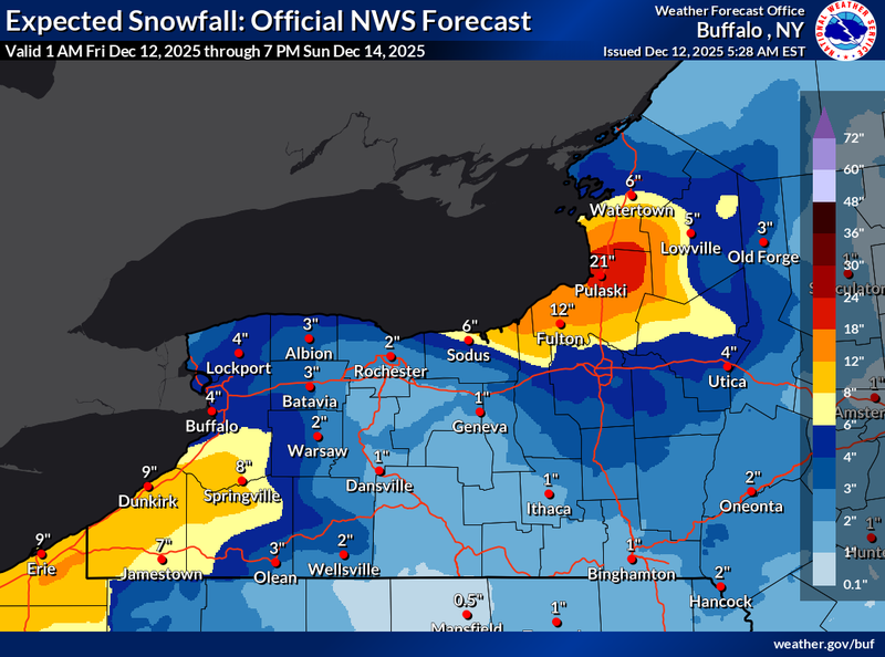

While the Buffalo metro area may see a quick burst and few inches of lake effect snow early Saturday, the real story will be the more intense lake effect snow bands that will concentrate on the southern tier through the weekend.
A Winter Storm Watch is posted for southern Erie, Chautauqua and Cattaraugus counties early Saturday, through Sunday night.
"Lake effect snow is going to develop," National Weather Service meteorologist John Hitchcock tells WBEN. "First up in the metro area in Niagara County overnight tonight. It won't be up here for too long, then heads south into the southtowns and southern tier as we go through Saturday."
Hitchcock says a few inches will fall across the metro area first, before heading south to the Boston Hills and southern tier for the remainder of the weekend.
"Down there, we could be looking at 7 or 8 inches or more of accumulation through the weekend...well south of the southtowns into the southern tier."
It will be a cold weekend, as much colder air moves back into the area Saturday night and Sunday.
WINTER STORM WATCH REMAINS IN EFFECT FROM SATURDAY MORNING THROUGH LATE SUNDAY NIGHT
* WHAT...Heavy lake effect snow possible. Total snow accumulations of 7 inches or more possible in the most persistent lake snows.
Winds could gust as high as 35 mph, producing blowing and drifting snow.
* WHERE...Chautauqua, Cattaraugus, and Southern Erie Counties. The greatest accumulations will likely focus across the higher terrain of the Chautauqua Ridge and Boston Hills.
* WHEN...From Saturday morning through late Sunday night.
* IMPACTS...Travel could be difficult with snow covered roads and poor visibility.
PRECAUTIONARY/PREPAREDNESS ACTIONS...
Narrow bands of heavy snow could bring rapidly changing road conditions and visibilities. Localized travel problems will be possible.