


It's so exciting to think about this forecast after all we’ve been through this winter. Except for the fact that there is a mention of “slush” later in the week. But let's not even talk about that yet. Let's talk about the next few days.
WCCO Chief Meteorologist Paul Douglas takes us through the week in weather.
Beautiful Weekday Weather on Tap
Can we can be in denial about what's coming this weekend? For now, yes.
“If we don't talk about it, it won't happen. Even if we do talk about it, it may not happen,” jokes Douglas. “I prefer to focus on the good, the positive and in the case of today, virtually cloudless blue sky, well into the sixties should be a beautiful Monday as Mondays go.”
But wait, there's more. It gets even nicer as we approach midweek.
“The models are hinting at seventies, really from tomorrow through Friday,” Douglas says. “And in spite of the pet glacier in your yard, it could actually get up to 80 on Wednesday, which is 20 degrees warmer than average.”
By Friday, Change is Afoot
And then some thunderstorms are coming in late Friday, which heralds the arrival of colder air.
“And yeah, it's too early for specifics,” Douglas says. “Let me just say that I'm not taking my driveway stakes out just yet. I'm going to give it another week or two because Old Man Winter is like a rabid dog and it looks like winter might come back for one more brief bite this weekend.”
Douglas says it is too early for the dreaded “S” word (yes, snow), but he says it could show up again on Saturday night. Stay tuned.
Flooding is Still an Issue
We are suddenly melting snow very fast, as your sump pumps have been telling you.
“Well, there are flood warnings in effect right now,” Douglas says. “Carver County on the South Fork of the Crow River. There’s minor flooding expected there in Carver County. And we also have flood warnings in effect for the Cottonwood River in Brown County in southwestern Minnesota for minor flooding, and the Redwood River in Redwood County also a potential for some minor flooding south and west of Willmar. So we'll keep an eye on that.”
Of course there is still major concern with some of Minnesota’s biggest rivers.
“Especially the Mississippi and the Saint Croix,” Douglas says. “Again, if you've had flooding in the past, you need to stay alert and stay tuned and have a plan just in case.”
Douglas says the good news is he doesn’t see any heavy rain in the forecast right now.
“Certainly not this week. The warmth will not be accompanied by heavy rain,” Douglas told Vineeta Sawkar on the WCCO Morning News. “We'll see a little bit of rain, I think Friday night, Saturday before a changeover to snow late Saturday and Saturday night.”
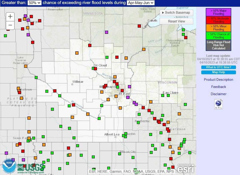 The current flood outlook shows a better than 50% for major and moderate flooding along the Mississippi, St. Croix, and Red Rivers in Minnesota, North Dakota and Wisconsin.(NOAA / National Weather Service)
Forecast
Monday: Sunny and beautiful. High 69.
Tuesday: Warm with our first 70 of the year. High 76, low 48.
Wednesday: Is it June? High 80, low 56.
Thursday: Still summery. High 77, low 47.
Friday: Still sunny and warm but changing late. High 74, low 56. Chance of precipitation 70% later in the day.
Saturday: Weather whiplash. Rain may change to snow late. High 40, low 38. Chance of precipitation 80%.


