It is not lost on Minnesotans how warm, and snow-free, it has been across the state. Normally by mid-December, there's at least some snow on the ground accompanied by a few cold snaps.
But that is not happening so far, and according to WCCO's Chief Meteorologist Paul Douglas, it is going to stay this way for a while. That's good news for winter-haters and horrible news if you just bought a snowmobile or like to ice fish.
The main culprit? El Niño. It's not the only thing driving this warm and dry spike in the Upper Midwest, but it's the biggest one. So what is El Niño? Or it's cousin, La Niña?
First, the name. El Nino is Spanish for "the child" or "the little boy" more specifically. Douglas explains the name comes from the Christ Child, or Jesus.
South American fishermen first noticed periods of unusually warm water in the Pacific Ocean in the 1600s. The full name they used was El Niño de Navidad, because El Niño typically peaks around December.
"It also means a firehose of mild, Pacific air for much of the lower 48 (states), and much of Canada," explains Douglas. "And that's exactly what we're seeing. This El Niño pattern will probably be with us most of the winter, starting to fade next spring."
La Niña means "Little Girl" and has the opposite effect that El Niño does. It's a cold event.
During normal conditions in the Pacific ocean, trade winds blow west along the equator, taking warm water from South America towards Asia. To replace that warm water, cold water rises from the depths — a process called upwelling. El Niño and La Niña are two opposing climate patterns that break these normal conditions. They are repeating cycles that have likely taken place for thousands of years.
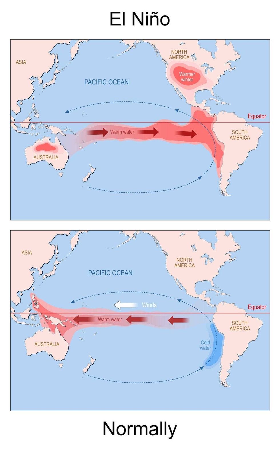 El Nino. world map with continents and arrows that indicating the direction of warm and cold water and winds.(Getty Images / ttsz)
There are varying degrees of El Niño and La Niña. What we're experiencing in 2023 is a "Strong" El Niño, so far at least. The temperature in those Pacific Ocean waters measured in November met the threshold for a "strong" El Niño which is 1.5 degrees (Celsius) above average. While a degree and a half doesn't sound like much, it's a very large spike in the world of climate and ocean temperatures. In fact, there is a 35% chance of this event becoming "historically strong" (≥ 2.0°C) for the November-January season.
Douglas says when that happens, it creates a change in how the jet stream flows over the United States and Canada. It normally pulls cold, Arctic air south into Minnesota, but with El Niño is buckles and carries the warmer Pacific air across the upper part of the country. And it pushes most precipitation south and east.
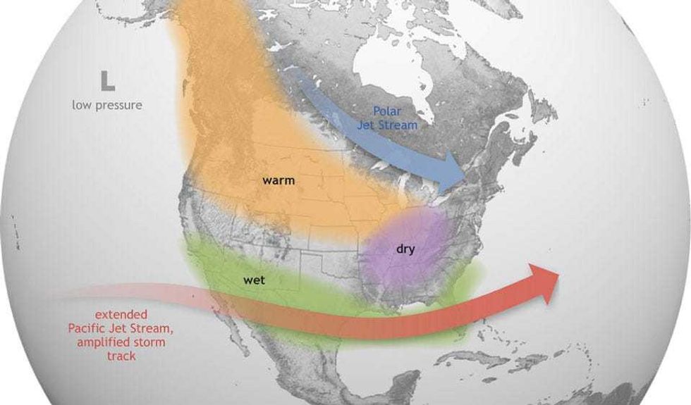 A look at what typically happens in North America during an El Nino event, with warm and dry conditions across most of the northern U.S.(NOAA / National Weather Service)
"There's a very strong correlation, when the waters of the equatorial Pacific spike, when they warm up dramatically, that tends to keep the subtropical jet stream, the main highway for storms, south of Minnesota," says Douglas. "Many storms, not all, sail off to the south of Minnesota and that's what we're seeing this winter."
It also creates drier and warmer conditions on the other side of the Pacific in places like Australia and Indonesia. The most recent strong El Niño was in 2015-2016 and led to a record warmest year. 2023 already surpassed it.
For Minnesota, that means a very mild winter in most cases. According to the Minnesota Department of Natural Resources, the 25 El Niño winters since 1950 averaged 1.8 degrees F warmer on a statewide basis than non-El Niño winters, and have produced an average of 22% less snow (12.7 inches) in the Twin Cities.
"Odds favor milder and drier, and yes that probably means less snow. At the rate we're going I'll be surprised if we get 30 to 40 inches of snow, all winter long," Douglas said. "Who knows what's going to happen in February and March, but the pattern not right for significant snow through at least early January."
The warmest December-through-February on record in Minnesota came during the very strong 1997-98 El Niño episode. The very strong events in 2015-16 and 1982-83, the strong El Niño in 1991-92, plus the moderate one in 1986-87 also are associated with winters that are among Minnesota's 10 warmest on record. 2023 is already on that track.
In addition to El Niño we're experiencing the warmest year on record in 2023 worldwide. Douglas says while the planet is certainly warmer overall, El Niño just gives it more juice.
"It's been the warmest period since October 1st for the metro area and most of Minnesota on record," says Douglas about records that go back to 1872. "So we have background warming, yes the planet, the oceans are warming, and that is further spiking this natural phenomenon which is El Niño."
That intersection of El Niño and climate change is only going to supercharge these events going forward says Douglas.
Does that mean it won't snow or get cold this winter? Not at all. El Niño influences the weather but it doesn't eliminate entire seasons. In fact, the infamous 1991 Halloween Blizzard occurred during a strong El Niño event.
More recently, the weak El Niño of 2018-19 began with a warm "snow drought" that lasted through mid-January, but then gave way to an winter barrage that included extreme cold and almost endless accumulating snow.
But the data is clear in Minnesota. A strong El Niño points towards warmer and drier overall, something that will be easy to see looking out your windows on Christmas morning at your green and brown lawns.
Other Historic El Niño Events
It is thought that there have been at least 30 El Niño events since 1900.
The 1982–83, 1997–98 and 2014–16 events are among the strongest on record. Since 2000, El Niño events have been observed in 2002–03, 2004–05, 2006–07, 2009–10, 2014–16, 2018–19, and this one beginning in 2023.