Welcome to April in Minnesota. Did we mention it's January 31st? It's going to be over 50 degrees (above) on Wednesday.
Also, 7.3 inches of snow. That's not one storm. That's the total for the entire winter so far at MSP Airport. A quick reminder that last winter we finished over 90 inches so weather whiplash should be in your vocabulary.
"It's going to snow again later in February," says WCCO Chief Meteorologist Paul Douglas. "I hope so for anyone who loves winter sports. I think we'll have a few wintery relapses, I wouldn't write off snow and cold just yet. What a crazy winter we're having."
And if you ware one of those winter lovers, this is definitely one of the worst Minnesota winters of your lifetime.
A WARM DAY AND STILL WARM NEXT WEEK
Starting with Wednesday, expect record temperatures across the entire state with 50s the norm, possibly higher.
"I've upped the high one degree to 54," says Douglas. "The record high is 46 in 2009. I think we'll break that by 1:00 p.m. Blue sky, it will feel like a typical day in mid-April."
The highest temperature ever recorded in January in the Twin Cities is 58 and while we will probably just fall short of that, it's close.
"I still wouldn't be shocked to see a 60 out by Mankato, Redwood Falls, Willmar. It's possible," Douglas predicts. "The normal high right now is 24. Unbelievable. Do the math."
This warmer than normal weather is sticking around for at least another week to ten days says Douglas. Just not quite in the 50s.
"It cools off. Yes, cools off, into the 40s tomorrow into the weekend," he says. "The rain chances Saturday have receded. Most of it will stay to our south. But 40s right into next week."
You'll feel a little difference on Thursday with windy, cloudy conditions, but far from what it could feel like this time of year.
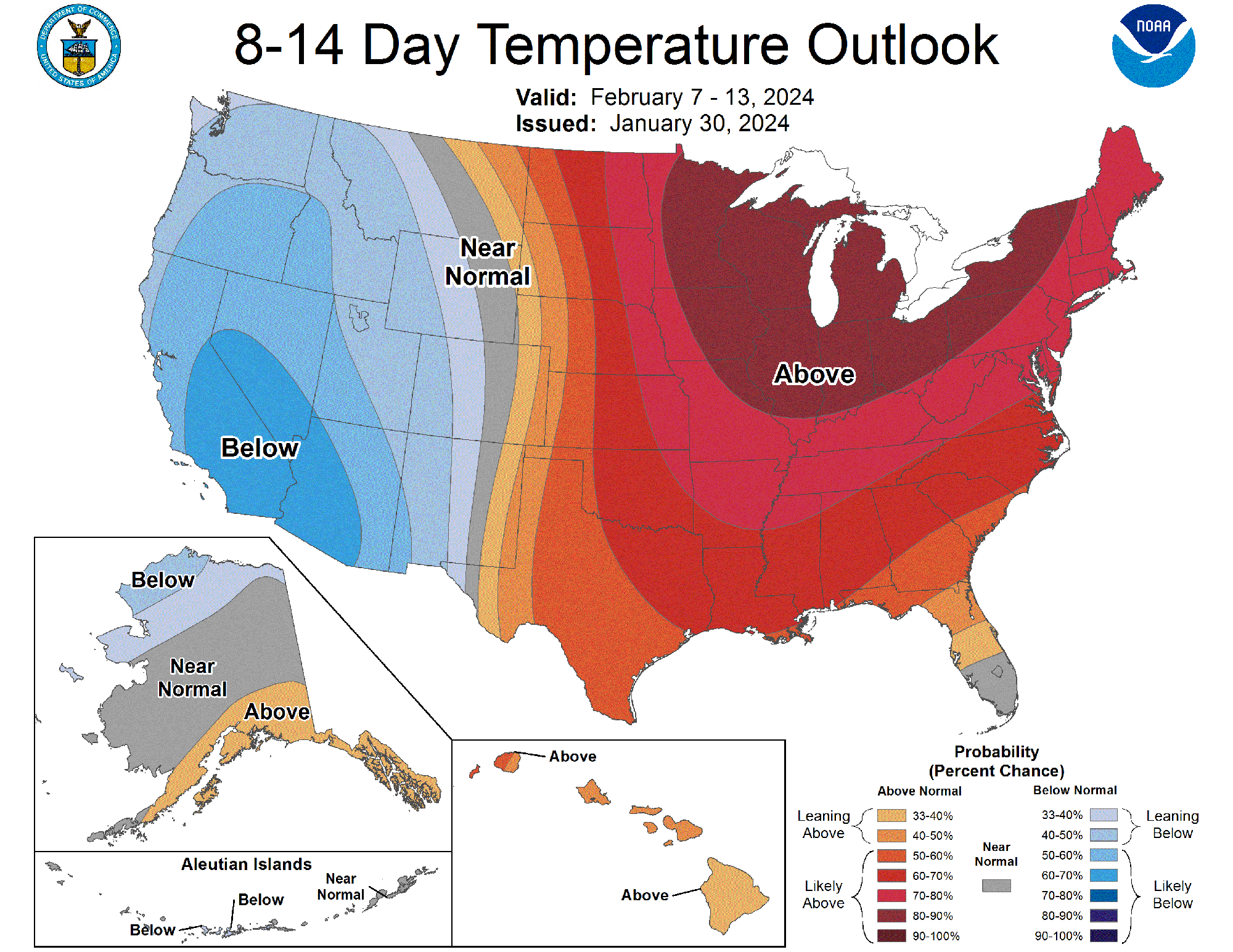 The two-week temperature outlook from the National Weather Service calls for more above normal weather for Minnesota and much of the eastern two-thirds of the U.S.(Image courtesy of the National Weather Service)
There is another shot at some rain, maybe snow, the end of next week.
"Some of the long range guidance hinting at a little bit of rain next Thursday and Friday, maybe ending as a little wet snow up north," Douglas told Vineeta Sawkar on the WCCO Morning News. "The maps look like April today and right through next week look more like March."
WE HAVE TO TALK ABOUT DROUGHT AGAIN
Speaking of precipitation, Minnesota is a state full of water, and much of that water comes in the form of winter snow. What happens when the snow doesn't fall?
"It's the impact this is going to have on our plant life, on our drought," Douglas says. "Most of the state is still in a drought. We need moisture. Are we going to be using the 'D' word throughout 2024? I don't know. A lot of things to consider."
That drought Douglas mentions is still a real thing, and coming off a dry summer, this could become a major issue if Minnesota continues to miss out on the snow in February-March.
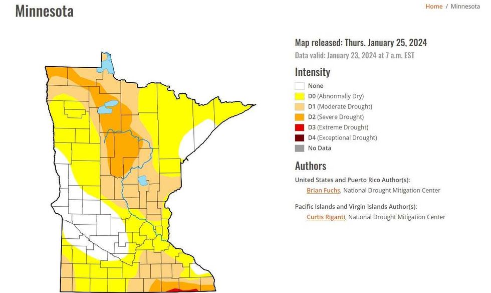 The U.S. Drought Monitor valid January 25th shows fairly dry conditions across Minnesota. And with only 7 inches of snow so far, there's very little water on top of the still frozen ground.(U.S. Drought Monitor / National Weather Service)
There's a very small pocket of Extreme Drought in far southeastern Minnesota, severe drought in the north-central part of the state, and much of the rest is either in moderate drought or abnormally dry.
It's a serious situation for farmers, water levels, and our land of 10,000+ lakes if that normal snowfall doesn't show up.
If you're wondering how our 7.3 inches stacks up all-time? The lowest seasonal snowfall according to the National Weather Service Twin Cities is 1986-1987 when a grand total of 17.4 inches fell at MSP Airport.
The most serious drought in Minnesota's recorded history was in 1988, and that drought began in the fall of '87. Yes, the same winter where the least amount of snow fell in the Twin Cities.
There is nothing that says this is a repeat, yet, but as Douglas says, worth keeping an eye on if the lack of snow and precipitation continues into spring.
CANADA IS COOKING TOO
Minnesota is not alone in seeing warm weather this January. Just look to the north.
"It gets increasingly bizarre. I saw one temperature yesterday in Saskatchewan, Canada of 70," says Douglas. "It was actually warmer in parts of Saskatchewan than it was in Key West, Florida. So, just a mixed up atmosphere."
Calgary and Edmonton hit daily record highs on Tuesday, 59 and 53 respectively, with Edmonton recording its highest January temperature since 1941. This is after much of Western Canada saw the warmest December on record.
And remember all of that wildfire smoke that was drifting over Minnesota this past summer? That was because this same portion of Canada was "unseasonably warm and dry" in the spring and summer, leading to a record year for those fires that burned out of control.
While much of this year's unseasonable warmth has been attributed to El Niño, climate change increases the extremity and back-and-forth fluctuation of weather systems, making the impacts of these weather systems more severe, as evidenced by 2023 being the planet's hottest year on record.