


There's a lot of snow out there! By there, we mean the Northeast which is getting pounded on Tuesday. Not here. Rinse, repeat.
But, some snow is on the way for parts of Minnesota according to Meteorologist Paul Douglas.
"It looks a little more impressive for snow lovers Wednesday night. We could end up with, wait for it, two inches of slush. It's not going to last very long, whatever we get," he says.
Rush hour Thursday morning could be slushy and slow according to Douglas. That's it. That's winter in 2023-24 in Minnesota.
"This doesn't really qualify as a snowstorm. It's more of a nuisance event," Douglas explains. "The models a little more impressive than they were yesterday. It's something."
So there's that. And then we warm back up again in the year that winter forgot.
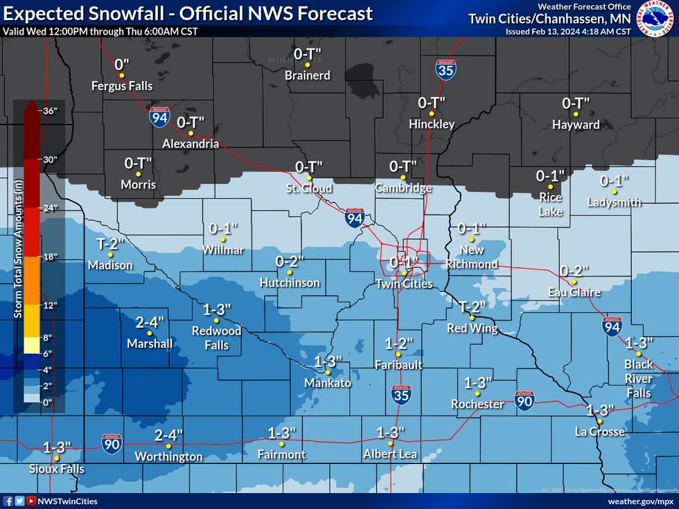 The expected snowfall map for this Wednesday-Thursday isn't very impressive.(Image: National Weather Service Twin Cities / NOAA)
The Rest of This Week
We begin with a quiet Tuesday, and mostly quiet Wednesday across the Twin Cities.
"We're looking at upper-30s, clouds. Tomorrow the sun should return for a time, and I think we should be in the low-40s," Douglas told Vineeta Sawkar on the WCCO Morning News. "And then that clipper comes in with an inch or two Wednesday night. Wouldn't be shocked to see three in some of the southern suburbs.
Douglas says there is no more snow in the immediate forecast so this little bit is going to be it for the Twin Cities. Which, to this point, is stuck on 7.3 inches which is the least ever in mid-February.
"That's as good as it gets for snow lovers looking out a couple of weeks," Douglas says.
It's not great news, but it's going to help a couple of Twin Cities outdoor events like the World Cup Cross Country Ski race taking place at Minneapolis' Theodore Wirth Park this weekend. They've been making and trucking in snow, with temps barely cool enough to keep it from melting. This little bit of snow should stick around for the event on Saturday before we warm back up. Again.
The Longest January Thaw Ever
Speaking of record streaks, this is now an historically long streak of above-freezing temps.
"Today is the 23rd day in a row of this January thaw, which has spilled over into February," says Douglas. "And according to Dr. Kenny Blumenfeld, of the Minnesota Climatology Office, this is the longest January thaw on record. Normally it last two days. Maybe. Give or take. And (Wednesday) will be 24, and then we'll cool off below freezing."
For two days. There's one day of winter on Friday, with highs in the 20s. Then we bounce back up above freezing.
"By Saturday we should be upper-30s," Douglas said. "The European Model has us consistently in the 40s again next week, and boy, looking at the models I think we could see a few 50s again in late-February."
January had a departure of 9.2 degrees above normal which is by far the highest in the nation, most of which saw warmer-than-normal temperatures. Wisconsin was also a scorching 8.5 degrees above normal. This comes after December which was a blistering 16 degrees above normal.
All of this is setting the stage for....
Warmest Winter Ever?
It's looking more and more like it with the forecast for next week. Meteorological winter is defined as December-January-February, the three coldest months of the year, in Minnesota. But not this year.
"I want to go on record. I think this will end up being the warmest winter on record for the Twin Cities and most of Minnesota," Douglas says. "It's mind-blowing how persistent this warm signal is. I'm just the messenger. Unless you like it, in which case it's all my fault, ok?"
International Falls recorded its first January 50 F temperature in its history, and the Twin Cities broke its record for number of 50 F days for the season by early February. Most areas in the state had received less than 25% of their normal snowfall through the first week of February, and had seen 20-55 days since December 1st with no snow on the ground.
The warmest year on record, by the way, goes back to 1877-1878, dubbed "the year without winter". It was a remarkable year that for 145 years has seemed unbeatable (over 2 degrees warmer than the second warmest which is a massive departure on its own).
Until now. It sure looks like winter just plain forgot about Minnesota this year.


