Get ready for another blast of "early spring". 60s are back in the Twin Cities Monday and Tuesday says WCCO Chief Meteorologist Paul Douglas.
He breaks down the next week, which could come with some much-needed moisture and explains how it's getting harder and harder for him to predict snow.
WARM TWO DAYS
Monday could set another record during a winter season that has broken just about all of them.
"Typical for early May. The record is 66 back in 2016, and I think we'll at least tie that," says Douglas. "It's weird, for months now, the weather models have been consistently too cool. It's like the models can't keep up with this pattern between the super El Nino and a warming climate."
Expect the same sort of situation on Tuesday. Feel free to make a tee-time says Douglas.
"Today is going to be a record day, sunshine, light winds, typical for the first few days of May and tomorrow should be nearly as nice," Douglas predicts. "Maybe a couple of degrees cooler instead of 66. It may be 63 or 64. Keep in mind the normal high now is 39, the normal low is 22. So way above average, not just in the metro but pretty much statewide."
COOLS OFF AND (GASP!) RAIN?
The temp will fall a bit on Wednesday but the bigger story is some potential precipitation says Douglas.
"Cools off a little bit Wednesday. Looks better for rain on Thursday and yes, it will be warm enough aloft," he tells Vineeta Sawkar on the WCCO Morning News. "The lowest mile of the atmosphere still well above freezing. So that southern storm has been tracking a little farther north and I think it will brush us with some rain. Not what we need, but we take any rain at this point."
This warm and mostly snow-free winter may have been easier to take if you're not a fan of cold and shoveling. But there is a downside and that is very simply that Minnesota is drying out.
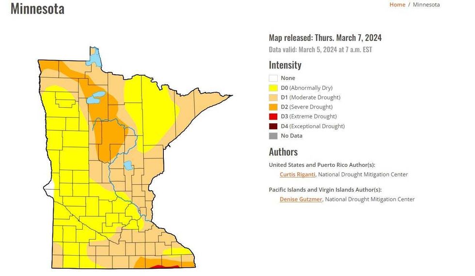 The U.S. Drought Monitor Map for Minnesota on March 7 shows the state is abnormally dry with pockets of Moderate, Severe and even Extreme Drought.(Image: U.S. Drought Monitor / NOAA)
"The worst drought conditions statewide since October," says Douglas. "We've been in a drought really for the better part of three, three and a half years. So, I am worried about drought, I'm hoping the pattern reverses itself and we don't have to be using the D word all this year. But two thirds of the state in either moderate or severe drought, including much of the metro. So we'll cheer on the rain Thursday."
Douglas adds he wouldn't be surprised to see some snow either. That is not going to be a major concern however. It'll still be too warm to really stick or ice up the roads.
"It could end as a few wet snowflakes. Perhaps Friday morning could be a little bit of slush south of the metro," Douglas said. "Could be some flurries again on Sunday. Wouldn't be shocked to see a dusting, especially during the nighttime hours during the day with that high sun angle."
GETTING HARDER TO PREDICT SIGNIFICANT SNOW
That high sun angle is also making it to predict anything in the way of wintery, snowy weather even though it's only mid-March. Normally this time of year, there's enough snow on the ground to keep reflecting sunlight, keeping it cooler which of course makes snow more likely.
There's literally no snow on the ground in Minnesota outside of a couple extreme northern spots along the Canadian border and the Minnesota Arrowhead.
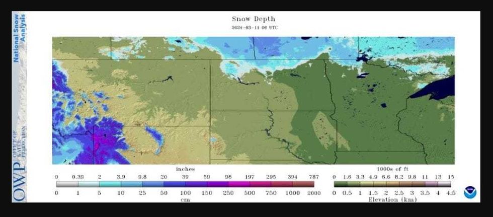 If you're looking for snow in Minnesota there are very small parts that have some on the ground, mostly towards Lake of the Woods and a couple of areas along the Arrowhead and Boundary Waters.(Image: National Weather Service / NOAA)
Douglas says we're not quite done with snow yet however. Some more typically March temps are coming.
"I think we will probably get a few slushy storms here later in March and April although, the European long range weather model is hinting at more 60s and a shot at 70 the last couple of days of March," he says. "Could be some flurries again on Sunday. Wouldn't be shocked to see a dusting, especially during the nighttime hours during the day with that high sun angle. There's no question, we're heading into a cooler phase, temperatures closer to average next week, but still low, maybe some mid-forties up north holding in the upper thirties. So more typical March weather kicks in this weekend."
Douglas adds that we're really down to winter's last two-week gasp at this point.
"The sun is high in the sky as it was really in late September. It's hard to keep snow on the ground as we sail into mid and late March, but can't rule out a few slushy snowfalls next week and the week after. But nothing polar."
FIRE RISK
For anyone in far Southwest Minnesota, the National Weather Service has issued a Red Flag Warning until 7:00 p.m. Monday night.
Some high winds and low relative humidity are making fire conditions very dangerous from Marshall to Redwood Falls and Worthington, Minnesota.
Even though the warning is only for that part of the state, with much of Minnesota too dry there is an elevated fire risk. The winds will be lighter so there isn't a Red Flag Warning issued but conditions are still ripe for fires to spread quickly.