If you're looking for a simple forecast with clear snow totals on Tuesday? Good luck. Because this is a tricky one, a forecast even the National Weather Service calls "complex."
But for most of Minnesota, some form of nasty winter weather is coming. Here's what we know:
Your experience will really depend on where you are, even in the Twin Cities metro.
"This one, the snow totals aren't so high," says WCCO-TV Chief Meteorologist Chris Shaffer. "It's just a sloppy system and that's the problem, where there's gonna be a lot of phase changes. If you look at radar right now, the storm is still over North Dakota and it looks like a slice of Neapolitan ice cream coming in at an angle with snow on the northeastern end, the kind of strawberry in the middle, that's the mixed precipitation. And then the rain on the southern flank, and it's gonna keep coming down at that angle. Typical Alberta Clipper system style."
Where you get the snow, the mix, and the rain is going to have everything to do with the snow amounts - eventually. For now, it won't be an issue, right through midday in the Twin Cities.
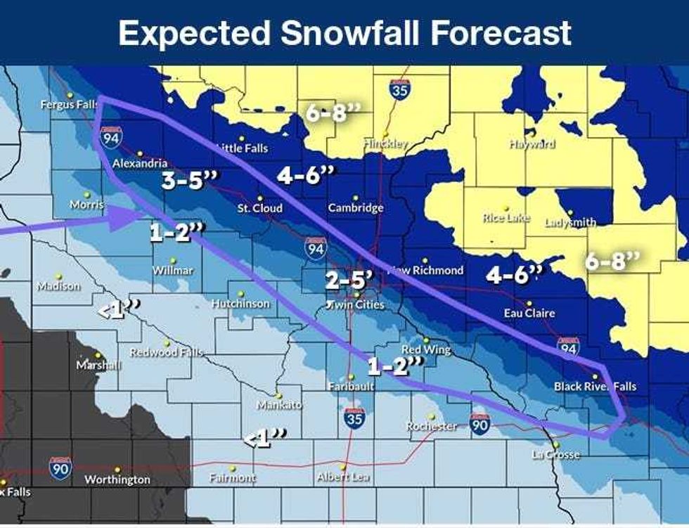
"There's a little mist here and there, but things will be fine," says Shaffer. "Once the snow starts early this afternoon, there'll be a rapid accumulation on the roadways. In the metro, there could be a little mixing in with some rain at times and then going back to snow. We're right on that middle ice cream Neapolitan line that we'll see kind of both of this. North, if you live in St. Cloud, Little Falls, Cambridge, New Richmond, Wisconsin, even, it's all snow for you. You could see 4 to 8 inches of snow."
There is a sharp gradient of snowfall totals and it will mainly land along Interstate 94. North of that, more snow. South of that, more of a mix.
"And then in the southwestern parts of the state heading toward Hutchinson, even, Faribault, Mankato, maybe 1 inch, maybe 2," Shaffer predicts. "Not much because you'll see more of that rain coming through."
Shaffer says the Twin Cities should see more in the 2-4 inch range of snow totals. There might be some rain mixed in, but the bulk of the metro is really on the southern edge of mostly snow.
"With 2 maybe down in Shakopee, 4 inches as you head toward up to say Scandia, Anoka, Ramsey, all the northern tiers," he told Vineeta Sawkar on the WCCO Morning News.
 It'll be a sharp cutoff, directly over the Twin Cities, as to where the heaviest snow will fall on Tuesday and Wednesday.(National Weather Service)
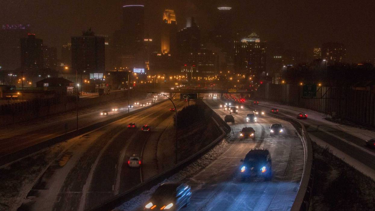
That afternoon commute on Tuesday could be a doozy. And wind will become a problem, even in the metro with gusts approaching 40 mph. To the west and north, those winds will be even stronger. In southwest Minnesota, ground blizzard conditions will be possible, especially in the overnight hours.
"The temperatures drop off quickly as that snow moves out," Shaffer adds. "Your commute home later is going to be slower. The roads will be in tougher shape. One good thing with the warmer temps, the MnDOT plows and the salt and chemicals, they go to work rapidly. By tomorrow morning, I would expect a longer commute still, just residual stuff. 23 is the high. It's going to be very windy overnight and during the day tomorrow."
That's just the appetizer because the cold is going to get very real heading towards the weekend according to Shaffer.
"We're talking about highs Friday and Saturday in the single digits," he says. "Likely dipping to the double digits below zero Friday night and Saturday night, which means if you're an early riser Saturday and Sunday, it's gonna feel like 20 to 25 below."
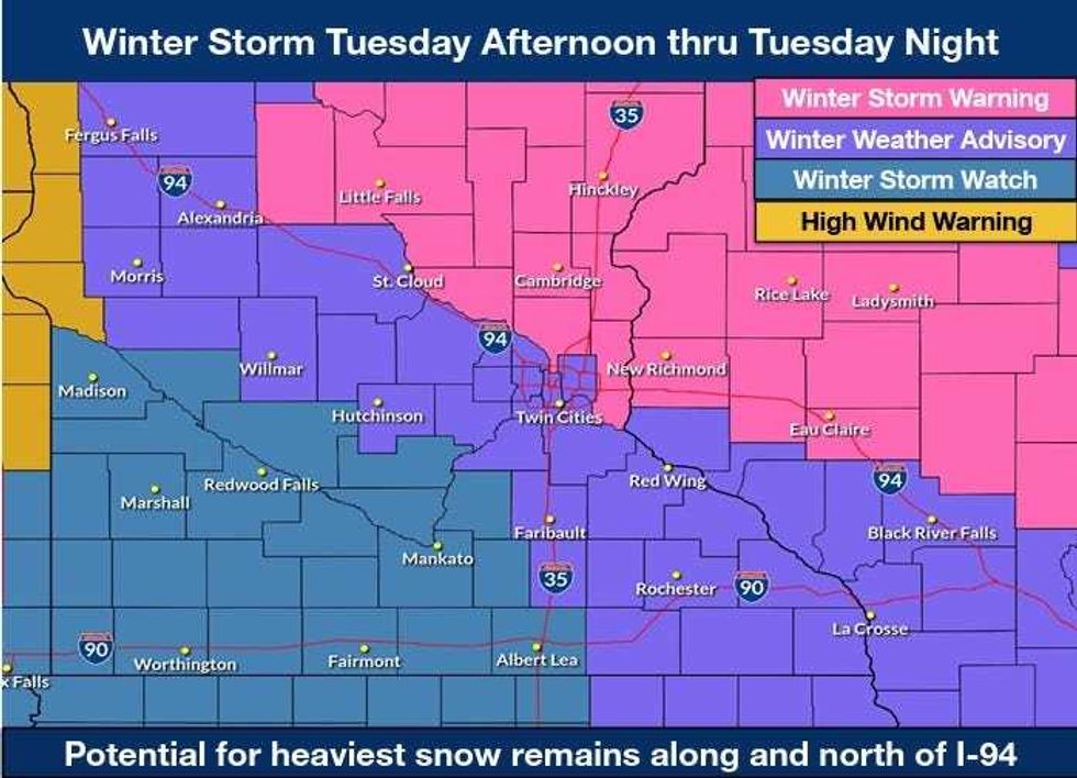 It's Chris Shaffer's Neapolitan ice cream storm, with a winter storm warning to the north and east, a winter weather advisory in the middle, and a winter storm watch to the southwest.(National Weather Service)
WINTER WEATHER ADVISORY 3 PM TUESDAY-6 AM WEDNESDAY
* WHAT...Mixed precipitation expected. Total snow accumulations between 1 and 3 inches and ice accumulations around a light glaze. Winds gusting as high as 35 mph.
* WHERE...Carver, Dakota, Hennepin, Ramsey, Scott, Rice, Steele, and Goodhue Counties.
* WHEN...From 3 PM Tuesday afternoon to 6 AM Wednesday.
* IMPACTS...Plan on slippery road conditions. The hazardous conditions will impact the Tuesday evening commute.
WINTER STORM WARNING NOON TUESDAY- 6 AM WEDNESDAY
* WHAT...Heavy mixed precipitation expected. Total snow accumulations between 4 and 7 inches and ice accumulations around a light glaze. Winds gusting as high as 40 mph.
* WHERE...Benton, Morrison, Sherburne, Todd, Anoka, Chisago, Isanti, Kanabec, and Mille Lacs Counties.
* WHEN...From noon Tuesday to 6 AM Wednesday.
* IMPACTS...Roads, and especially bridges and overpasses, will likely become slick and hazardous. Travel could be very difficult. The hazardous conditions will impact the Tuesday evening commute.
WINTER STORM WATCH TUESDAY EVENING THROUGH WEDNESDAY MORNING
* WHAT...Blizzard conditions possible. Total snow accumulations up to one inch possible. Winds could gust as high as 50 mph.
* WHERE...Renville, Sibley, Blue Earth, Brown, Faribault, Freeborn, Le Sueur, Martin, Nicollet, Waseca, Watonwan, Redwood, Chippewa, Lac Qui Parle, and Yellow Medicine Counties.
* WHEN...From Tuesday evening through Wednesday morning.
* IMPACTS...Roads, and especially bridges and overpasses, will likely become slick and hazardous. Visibilities may drop below 1/4 mile due to falling and blowing snow. Whiteout conditions are possible and may make travel treacherous and potentially life-threatening. Plan on slippery road conditions. The hazardous conditions could impact the Wednesday morning commute. Gusty winds could bring down tree branches.