DETROIT (WWJ) -- Cleanup is ongoing after severe storms, and possible tornadoes, roared through Metro Detroit overnight causing some fairly widespread damage.
The biggest concern going forward is flooding. With several more rounds of rain and thunderstorms the forecast, nearly the entire state of Michigan is under some sort of flood advisory.
The National Weather Service has issued a Flood Watch for the entire WWJ listening area, through Thursday night.
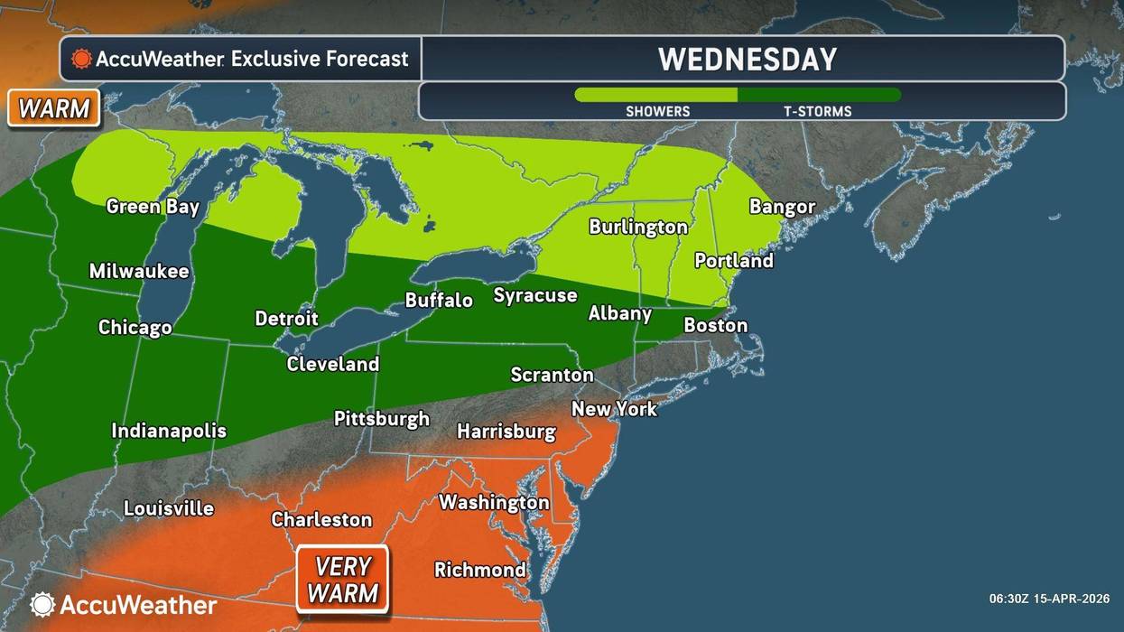
In Metro Detroit, WWJ AccuWeather Meteorologist Joe Lundberg forecasters were expecting more rain on Wednesday, It likely will not be as severe as Tuesday night, he said, however:
"Severe weather is still severe weather. There can be damaging wind gusts associated with those. And I think that's waiting until later this afternoon and into the night tonight. The bigger concern I have overall is we've had so much rain, there's a Flood Watch through late tomorrow night, and there's probably going to be some flooding downpours associated with these."
With this in mind, officials in Shelby Township are urging everyone to stay off the Clinton River until further notice, due to dangerous conditions.
Shelby Township Fire Department advised: "Recent weather and water flow have created unstable banks, strong currents, and hazardous debris that make the river unsafe for recreational use. These conditions significantly increase the risk of injury or accidental drowning, even for experienced individuals."
For your safety and the safety of first responders:
• Do not attempt to walk, fish, or recreate near or on the river
• Keep children and pets away from the water’s edge
• Report any emergencies immediately by calling 911
Flood Watch in effect through Thurs night. Potential exists for multiple rounds of showers and thunderstorms to move across the region during this time. Additional 1 to 2 inches of rainfall are expected by Thurs night, with locally higher totals possible. #miwx pic.twitter.com/YA7ndsjBzB
— NWS Detroit (@NWSDetroit) April 15, 2026
In the last 10 days, most of Southeast Michigan has seen 1.5 to 4.5 inches of rainfall, the National Weather Service said Wednesday. The WWJ listening area is looking at rain through Thursday night, with an additional one to two inches expected. Some areas could see as much as four, according to forecasters.
The NWS said excessive runoff may result in flooding of rivers, creeks, streams, and other low-lying and flood-prone locations. Creeks and streams may rise out of their banks. Flooding may occur in poor drainage and urban areas. Low-water crossings may be flooded.
[RELATED: Multiple possible tornadoes under investigation in Michigan, U-M's Yost Ice Arena damaged]
Scattered severe storms are possible again today. Some areas could see multiple rounds of storms through the day. #miwx pic.twitter.com/GVjuA8LUeG
— NWS Detroit (@NWSDetroit) April 15, 2026
Wednesday morning, southbound I-75 was closed from the Davison to I-94 due to flooding. A two-hour backup was reported. In Howell, I-96 was closed in both directions due to flooding. Both freeways have since ropened. (Stay with WWJ for updates on freeways closed t flooding during Traffic on the 8s. >>LISTEN LIVE)
Meanwhile, serious flooding is impacting several Northern Michigan communities.
In Cheboygan County, residents northwest of the Cheboygan River were ordered to evacuate after a levee spilled over near the Cheboygan Country Club. The golf course flooded and an evacuation order was sent to residents. This is unrelated to the ongoing and dangerous situation at the Cheboygan dam. All Cheboygan-area schools were closed.
Gov. Gretchen Whitmer declared a state of emergency for Cheboygan County on Friday after meltwater from record spring snowfall and persistent rain threatened to overwhelm the dam.
As work at the dam continues, staff from the Michigan Department of Natural Resources strategically placed sandbags around the Cheboygan Lock and Dam while contractors set up additional high-volume pumps to move water around the structure.
Inside the hydroelectric powerhouse, experts from the Army Corps of Engineers arrived Tuesday to work with the private facility’s owners and Consumers Energy to restart the hydroelectric plant’s turbine and return it to full capacity. State officials said this would help move water through the dam.
In Grand Traverse County, due to ongoing and anticipated flooding impacts, officials have declared a local State of Emergency. The sheriff's office warned that the bridge at Beitner Park failed overnight, Beitner Road is no longer passable, and flooding is creating hazardous conditions that may limit access to other areas,
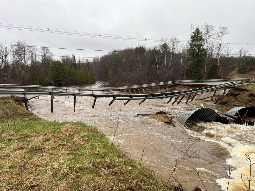
Beitner Bridge collapse
Grand Traverse County Road Commission
The state of emergency was extended Wednesday to include 32 additional counties: Alcona, Allegan, Alpena, Antrim, Arenac, Barry, Benzie, Charlevoix, Clare, Crawford, Emmet, Grand Traverse, Gratiot, Iosco, Kalkaska, Lake, Leelanau, Manistee, Menominee, Missaukee, Montcalm, Montmorency, Newaygo, Oceana, Ogemaw, Oscoda, Osceola, Presque Isle, Roscommon, Saginaw, Shiawassee and Wexford counties, as communities across the state deal with severe weather-related impacts from flooding and tornadoes.
In a spot of better news, it will remain warmer than normal in Metro Detroit through the end of the workweek, with highs around 70 degrees each day.
For now, Friday is looking drier, with a little sunshine, but there could be yet another round of storms over the weekend, when temperatures will drop a bit.
Check the 10-day forecast from AccuWeather at this link.
Keep your radio tuned to WWJ Newsradio 950 (AM 950) for the latest weather and traffic updates every 10 minutes on the :08s. >>> LISTEN LIVE HERE , or download the free Audacy app and follow WWJ. Tell Alexa: "Play WWJ nine-fifty."