


GRAND RAPIDS (WWJ) - A major snow storm taking aim at Michigan's westside is forecasted to be a doozy as widespread lake-effect snow will blanket the region in over a foot of snowfall, while other areas may see close to two feet from now through the weekend, experts say.
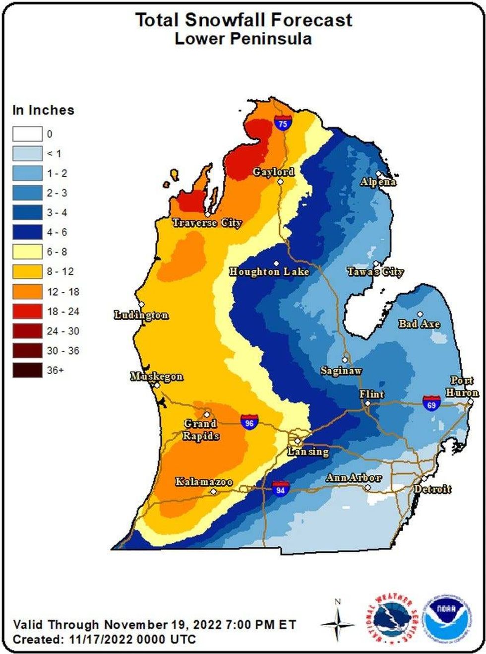
The National Weather Service had to adjust their snowfall totals overnight as weather forecast data consistently showed very heavy snowfall concentrating over southwest Lower Michigan and northwest Lower Michigan, possibly bringing 8 to 12 inches of snow going into the weekend.
Some areas, such as Leelanau County and inland cities such as Charlevoix and Petoskey, could see almost two feet of total snowfall from the storm.
Winter storm warnings have been issued for nine counties in West Michigan ahead of the storm, while Emmet and Charlevoix Counties in Northwest Lower Michigan were just upgraded to storm warning status from a Winter Weather Advisory within the last hour.
The warnings for Allegan, Ottawa and Van Buren counties go into effect at 7 p.m. Wednesday, the NSW advised, and run through 7 a.m. Saturday. Warnings posted for Barry, Calhoun, Eaton, Ionia, Kalamazoo, and Kent counties begin at 7 a.m. Thursday and run through 7 a.m. Saturday.
Experts warn even more snow is expected Saturday, but NWS warnings only have a maximum time period of 48 hours.
 National Weather Serivce
"A multi-day heavy lake effect snow event begins in earnest today," the NWS said. "The heaviest snow today is expected this afternoon and evening. The snow will continue into both Friday and Saturday as well. The heaviest snow of the entire event looks to occur Saturday afternoon and evening."
Intense snowfall rates of 1 inch to 2 inches per hour or higher will lead to quick accumulations on roadways and whiteout conditions with zero visibility at times, resulting in dangerous driving conditions.
AccuWeather Meteorologist Dean DeVore said currently the leading edge of the storm can be seen coming off of Lake Michigan and impacting cities as far east as Lansing and into the I-69 corridor.
"They're really getting nasty back toward Grand Rapids and down to Kalamazoo so both 96 and 94 would be tough rides west of I-69 right now and as you go into that southwest corner in that western side of Michigan, that were its going to be really bad over the next several days, a lot of lake-effect snow."
The heavy lake-effect snow is being fueled by warm 48° water on Lake Michigan combined with near 0° temperatures 5,000 ft. above, experts said. The snowfall forecast is subject to change as the wind direction and location of the heaviest snow bands becomes more exact, so residents are advised to check with their local weather experts as the storm develops.
The NSW is warning drivers that travel could be very difficult and near impossible in impacted area. Travelers are being advised to take precautions now.
"If you must travel, keep an extra flashlight, food, and water in your vehicle in case of an emergency," the NSW added.
DeVore said some snow shows could reach as far west as Metro Detroit with a few bands expected to bring flurries to the area Thursday. Some hefty snows showers can bring an inch or so of snowfall, with heavier amounts towards the west.


