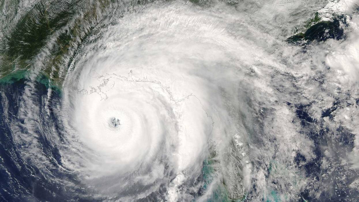
Hurricane Ida is expected to make landfall in Louisiana Sunday as a catastrophic Category 4 hurricane, bringing deadly weather conditions as it crosses over Southern Louisiana, WWL-TV reported.
For live updates on the hurricane and important information for the area check back here.
10:20 a.m.
Slidell police say no businesses are open in the city, including gas stations. Several red lights have gone out, and more are expected to go down in the next few hours.
Police say that once winds reach a certain speed, it will be difficult for officers to respond to emergencies, and in certain circumstances may be impossible until conditions improve.
Residents should shelter in place until after Hurricane Ida has passed.
10:10 a.m.
St. Bernard Parish President Guy Mcinnis posted a video shortly after talking with WWL-TV where he showed the ring levees around Delacroix that are about to overtop.
He said they are expected to overtop by about 5-6 feet and to stay overtopped for another 12 hours at least.
10 a.m.
9-1-1 is experiencing technical difficulties in New Orleans, according to the Orleans Parish Communications District.
Residents who need to report an emergency should call 504-821-2222.
City officials said Saturday they expect emergency response service to be spotty for at least the first 72 hours after the storm because of dangerous conditions and blocked roads.
Repost: 9-1-1 is experiencing temporary difficulties. Call 504-821-2222 for emergencies. #NOLA #Ida https://t.co/4bSEAJeEkc
— NOLA Ready (@nolaready) August 29, 2021
9:40 a.m.
St. Bernard Parish President Guy Mcinnis says some levees in the parish are close to overtopping.
Ring levees around Delacroix about to overtop, Mcinnis told WWL-TV.
The storm surge in the parish is about 6-8 feet, with higher surges expected in the coming hours.
9:35 a.m.
The Causeway will close at 11 a.m. because of high winds, bridge officials say.
Winds of up to 50 MPH have been clocked over Lake Pontchartrain.
9 a.m.
Hurricane Ida is continuing its trek towards Louisiana's coast, with an expected landfall somewhere near Port Fourchon. Landfall is expected sometime around noon.
Winds are picking up throughout the coastal parishes, with gusts beginning to jump up further inland. The worst weather is still expected to be through Sunday afternoon.
8:35 a.m.
Terrebonne Parish President Gordon Dove urged residents living in mobile homes of any kind to evacuate immediately ahead of winds up to 150 MPH expected in the parish Sunday night.
if you live in a trailer, if you live in a motor home, you live in a travel trailer, get out," Dove said. "Don't even think, even if you've got straps, that's not going to hold against that monster coming after us. This thing is bad and we are urging people to get out of these mobile homes because that's nothing to play with. They're going to blow apart."
He urged any residents with nowhere to go to contact the parish for accommodations. Terrebonne Parish has partnered with a number of hotels to house those displaced ahead of the storm.
8:20 a.m.
St. Charles Parish has set up two areas as a refuge of last resort:
Edward A Dufresne Community Center at 274 Judge Edward A. Dufresne Parkway (West Bank)
Harry Hurst Middle School gym located at 170 Road Runner Lane in Destrehan (East Bank)
Those who are unable to shelter anywhere else should go to the nearest of those locations immediately.
For a full list of shelters across Southeast Louisiana, click here.
8:10 a.m.
Here's the latest update on Hurricane Ida, expected to make landfall around noon as a devastating Category 4 hurricane.
7:55 a.m.
An Extreme Wind Warning has been issued for much of Southeast Louisiana. Winds over 115 MPH will begin in the area within the next hour. Residents are advised to treat the storm like a tornado and to take shelter in a sturdy structure away from windows.
7:35 a.m.
On Grand Isle, where power was just lost, water and wind are surging in.
Councilman Ricky Templet evacuated from the island, but sent WWL-TV some video showing the ferocity of the storm's outer bands.
Some residents have decided to stay, despite the mandatory evacuation order.