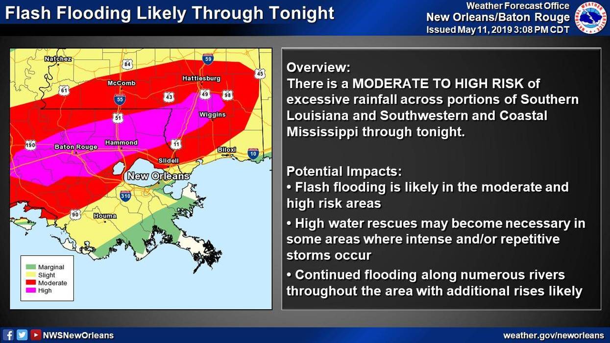
The National Weather Service is warning of a "moderate to high risk of excessive rainfall" in parts of St. Tammany, Tangipahoa, and Washington Parish.
⚠️RT: Life threatening flash flooding likely tonight through Sunday morning. a HIGH RISK (the highest threat level) for excessive rainfall exists along the I-12 corridor (BR metro, hammond, Covington, etc)It is rare that a High Risk for heavy rain is issued.⚠️PLEASE RETWEET⚠️ pic.twitter.com/fEJqi0UiLK
— NWS New Orleans (@NWSNewOrleans) May 11, 2019 "Rain rates at least 2 inches per hour (and likely greater on a local level) will be cause for significant concern," said the weather service's rainfall discussion. "Much of the Moderate Risk area has seen rainfall at 3 to 6 times normal over the past week."
A flash flood watch is in effect for the entire area except the immediate coast. That watch could quickly become a warning under a heavy thunderstorm.
The rain system should move on by midday Sunday.
Click here for interactive radar.
DETAILED FORECAST:SATURDAY EVENING:Mostly cloudy, breezy, warm and humid with a 70% chance for heavy rain and storms especially north of the lake. Temperatures in the 70s. Wind S 8-15 mph.
SATURDAY NIGHT:Cloudy and humid with a 60% chance for heavy rain and storms. Some could be strong. Lows around 72. Wind S 6-12 mph.
SUNDAY - MOTHER'S DAY:Mostly cloudy, warm and humid with a 60% chance for heavy rain and storms mainly in the morning and midday. Some could be strong to severe. Highs around 83. Wind W 6-12 mph.
SUNDAY NIGHT:Mostly cloudy and mild with a 10% chance for a shower. Lows around 69. Wind N 5-10 mph.
MONDAY:Partly cloudy, warm and less humid. Highs around 84. Wind N 5-10 mph.
TUESDAY:Sun/cloud mix and warm with a 20% chance for isolated showers or storms. Lows around 68. Highs around 82.
WEDNESDAY:Sun/cloud mix, warm and humid with a 30% chance for spotty showers or storms. Lows around 67. Highs around 83.
THURSDAY:Partly cloudy and warm. Lows around 70. Highs around 86.
FRIDAY:Mostly sunny, warm and more humid. Lows around 71. Highs around 87.
SATURDAY:Mostly sunny, warm and more humid with a 20% chance for showers or thunderstorms. Lows around 71. Highs around 87.