


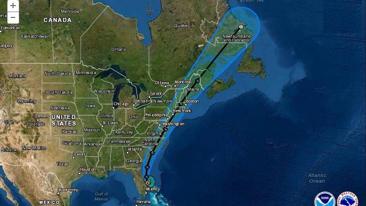
With 70 mile an hour sustained winds, Tropical Storm Isaias is forecast to make a path from Florida to Canada along the Eastern Seaboard.
"Interests... along the northeast coast of the United States should monitor the progress of Isaias," the National Hurricane Center advised.
Forecaster says the center of the storm is expected to follow the coast.
"Isaias is moving toward the north-northwest near 9 mph, and this general motion is expected to continue."
On the forecast track, the center of Isaias will pass just to the east of the Florida east coast through tonight.
"The center of Isaias will move offshore of the coast of Georgia and southern South Carolina on Monday, move inland over eastern North Carolina Monday night and move along the coast of the mid-Atlantic states on Tuesday."
The Hurricane Center says Isaias is expected to remain a strong tropical storm when it reaches the coast of northern South Carolina and southern North Carolina Monday night.
STORM SURGE:
- The combination of a dangerous storm surge and the tide will cause normally dry areas near the coast to be flooded by rising waters moving inland from the shoreline.
WIND:
- Hurricane conditions are be possible in the watch area in South and North Carolina Monday night and early Tuesday.
- Tropical storm conditions will spread northward within the Tropical Storm Warning area from Florida to North Carolina through Monday night.
- Tropical storm conditions are possible in the Tropical Storm Watch area beginning on Tuesday.
RAINFALL:
- The following rainfall accumulations are expected along and near the track of Isaias:
Northwest Bahamas: Additional 1 to 3 inches, isolated storm totals 12 inches.
Eastern Florida: Additional 1 to 3 inches, isolated storm totals 4 inches.
Coastal Georgia: 1 to 2 inches.
Carolinas and the Mid-Atlantic: 3 to 6 inches, isolated maximum totals 8 inches.
Southeast New York and much of New England: 2 to 4 inches, isolated maximum totals 6 inches.
- Heavy rainfall from Isaias will continue to result in potentially life-threatening flash flooding in the Northwestern Bahamas through tonight. Flash and urban flooding, some of which may be significant in the eastern Carolinas and the Mid-Atlantic, is expected through midweek along and near the path of Isaias across the East Coast of the United States. Widespread minor to isolated moderate river flooding is possible across portions of the Carolinas and the Mid-Atlantic.
SURF:
- Swells generated by Isaias are affecting portions of the Bahamas and the southeast coast of the United States and will spread northward along the U.S. east coast during the next couple of days. These swells are likely to cause life-threatening surf and rip current conditions.
TORNADOES:
- A few tornadoes will be possible over coastal South Carolina during the afternoon and evening on Monday, and across eastern North Carolina Monday evening and overnight.


