


A strong cold front is moving across the country and heading for the Gulf Coast.
WWL TV Meteorologist Payton Malone forecasts it will get to Southeast Louisiana tomorrow morning with scattered storms.
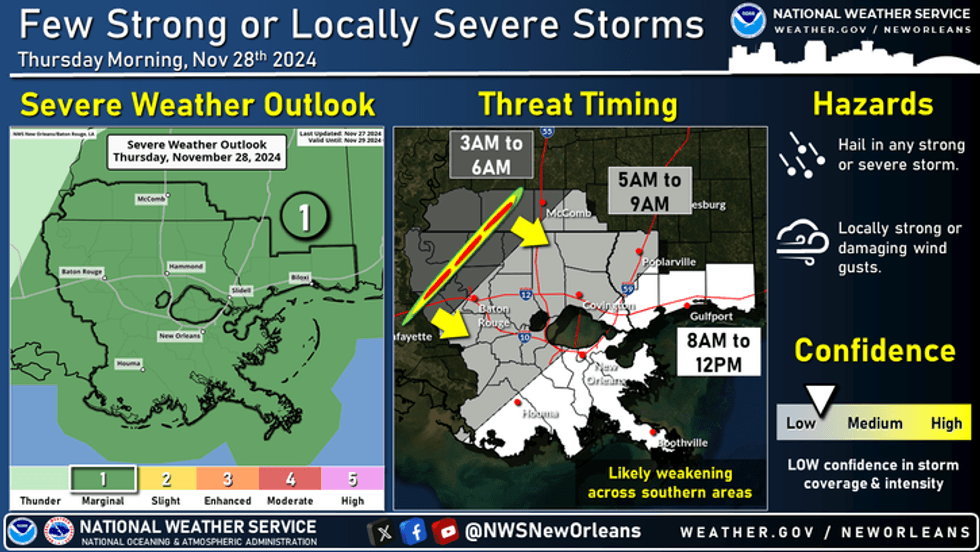 NWS
NWS
"Waking up Thanksgiving morning temperatures will be in the 60s ahead of the cold front," he explained. "After lunchtime temperatures will likely drop into the 60s and eventually the 50s by Thursday evening."
He says most of the rain will push out with the front.
"There could still be a few showers into Thursday night and early Friday morning."
He says Black Friday starts in the 40s and 50s.
"Things stay sharply colder with highs only in the 50s."
Another front moves through late Saturday reinforcing the cold air.
"It doesn't look like a widespread freeze, but the Northshore will be close each morning from Saturday morning all the way into Tuesday."
Temperatures will hover in the low to mid 30s each morning north of the lake, but the southshore will stay in the 40s.
Detailed Forecast...
TODAY:
Warmer afternoon. Partly sunny. Stray shower. Bit more humid. High: 77. Winds: S 6-12.
THANKSGIVING:
Mild to warm early, sharply falling temps through the afternoon and evening. Scattered rain early, again late evening. Mostly cloudy. Breezy, becoming windy. Low: S 66, N 64. Colder late. High: 73, then falling.
FRIDAY:
High clouds. Chilly and windy. Low: S 50, N 44. High: 58.
SATURDAY:
Mostly sunny. Chilly. Low: S 45, N 35. High: 58.
SUNDAY:
Mostly sunny. Chilly temps. Low: S 48, N 35. High: 59.
MONDAY:
Near freezing north, MS. Sunny and cold! Breezy late. Low: S 45, N 35. High: 59.
TUESDAY:
Sunny, some late clouds. Breezy and chilly. Low: S 46, N 37. High: 62.


