


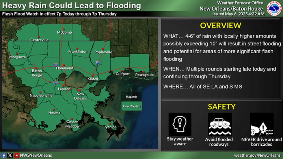
Forecasters say rounds of storms and heavy rain could cause street flooding today and tomorrow.
"Southeast Louisiana is bracing for several rounds of heavy rain and thunderstorms from Wednesday through Friday," WWL TV Meteorologist Payton Malone forecasts. "The heaviest rain is expected Wednesday morning and afternoon, with widespread accumulation totals of 2 to 4 inches, but a few spots could see more."
 NWS
NWS
He says the flood watch is in effect for most of the area through Thursday.
"The main threat will be street flooding. It’s a good idea to move vehicles to higher ground and stay prepared for rapidly changing conditions."
Detailed Forecast...
TODAY:
Flood Watch. 100% numerous off and on showers, storms. Breezy. More focus Southshore. High: 78. Winds: S 6-12.
THURSDAY:
Flood Watch. 40-50% scattered showers, storms. Low: S 70, N 66. High: 78.
FRIDAY:
60% scattered showers. Breezy. Low: S 69, N 65. High: 79.
SATURDAY:
30% spotty showers. Mostly cloudy. Low: S 67, N 61. High: 79.
SUNDAY:
30% spotty showers. Mostly cloudy. Low: S 67, N 56. High: 79.
MONDAY:
Mostly cloudy. Isolated shower. Less humid. Low: S 65, N 59. High: 80.
TUESDAY:
Mostly sunny. Less humid, nice. Low: S 65, N 58. High: 82.


