Forecasters say they still can't know with certainty if a pending ice storm will make it to New Orleans Saturday night or not.
"Hurricane hunters are flying into the system today," WWL TV Meteorologist Payton Malone said.
 NWS
NWS
He hopes with the additional data, the models can produce better forecast.
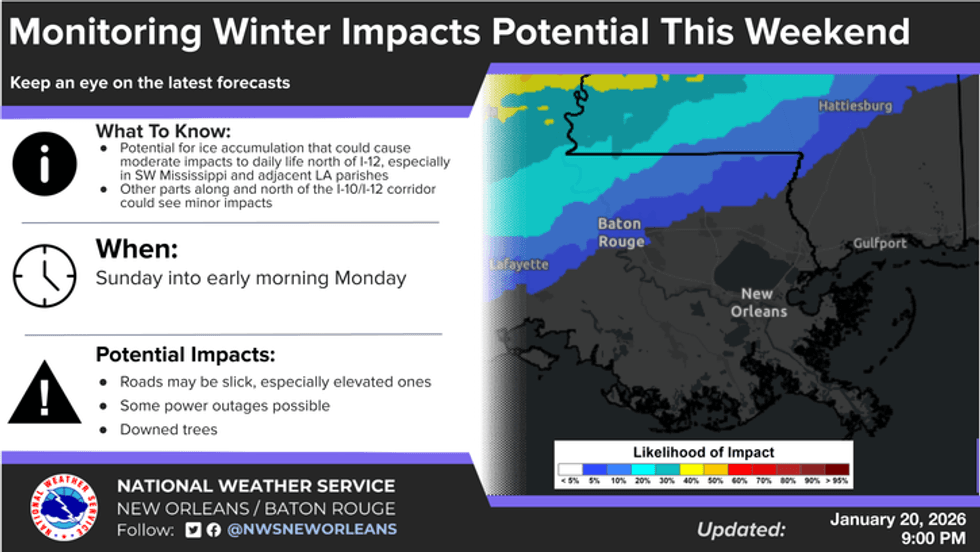
Malone says, right now, he feels that the icy mess will not get down to the New Orleans region.
"I do think we are going to miss the worst of it down on the Gulf Coast."
He expects the freeze line to stay in Mississippi, northern Louisiana and Texas.
"For our friends up north, this thing could really be a historic, crippling ice storm for some areas. You're talking days and days without travel around I-20."
Malone warns traveling to places like Dallas, Jackson, Shreveport and points north is ill-advised; as you may get stuck there for days.
"North of McComb... it is going to get really dicey."
He says they know a major winter outbreak will happen across the southern US.
"Travel could become difficult or impossible and power outages are possible."
That said, Malone says it is still too soon to say for sure that Southeast Louisiana will avoid all impacts.
"Some ice cannot be ruled out along the Gulf Coast on Sunday, especially north of the lake, as colder air pushes south. The chance is much lower south of the lake, but there is still uncertainty on how far south freezing temperatures could reach."