


Colder conditions are headed for Southeast Louisiana.
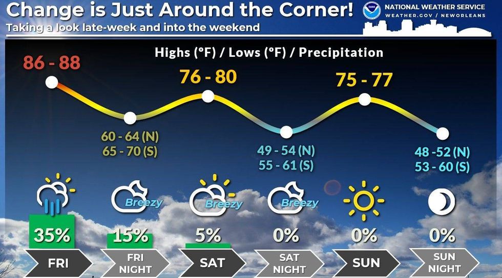
"By Saturday, morning lows in the 60s and an afternoon high in the upper 70s and some low 80s!" WWL TV Meteorologist Payton Malone forecasts. "By Sunday morning we'll drop into the 50s and 60s with some upper 40s possible farther north!"
 NWS
NWS
He says it won't last long.
"A gradual increase in temps and humidity through next week...but cooler than it has been!"
Meanwhile expect highs around 90 today and tomorrow, with a few showers Friday ahead of the front.
Detailed forecast:
TODAY:
Sun to partly cloudy. Very warm, nice. High: 89. Winds: SE 6-12.
THURSDAY:
Mostly dry day, but a few showers and t-storms late in the evening. Low: S 75, N 69. High: 90.
FRIDAY:
Mostly cloudy. 30-40% spotty showers. Becoming breezy, less humid late. Low: S 75, N 69. High: 85.
SATURDAY:
Partly cloudy. Much cooler, less humid. Breezy. Low: S 69, N 62. High: 80.
SUNDAY:
Partly cloudy. Much cooler, less humid. Low: S 63, N 52. High: 76.
MONDAY:
Mostly sunny. Mild, low humidity. Low: S 63, N 52. High: 79.
TUESDAY:
Mostly sunny. Very pleasant! Low: S 65, N 54. High: 83.


