


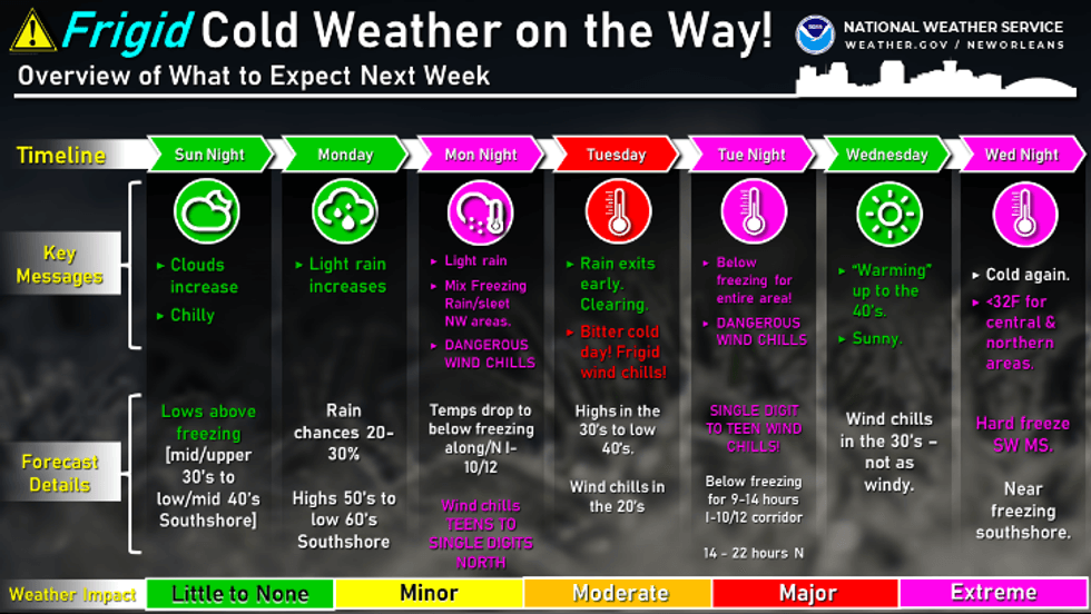
The National Weather Service says next week will see much colder conditions.
"Significant cold air and wind chills (are) on the way," the NWS office for New Orleans posted. "Temperatures will be plummeting Monday night with frigid temperatures all day on Tuesday."
 NWS
NWS
Temps drop even further in the middle of the week.
"The coldest morning will be Wednesday morning with lows reaching the teens to 20's and becoming below freezing for the entire area event to the coast."
 NWS
NWS
Forecasters say it'll be cold again Wednesday night with below freezing temperatures for much of the region.
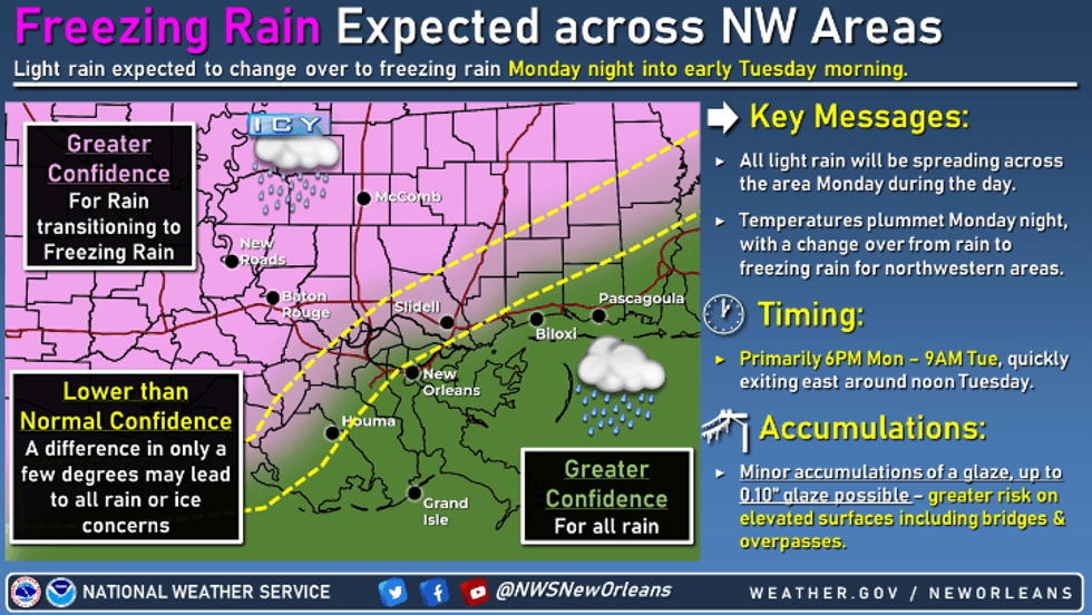
Freezing rain and icy roads are expected to be an issue to the north and west of the region. Some if it could be an issue on the Northshore
 NWS
NWS
New Orleans Forecast...
M.L.King Day
A 20 percent chance of showers after 4pm. Partly sunny, with a high near 62. Northeast wind 5 to 10 mph.
Monday Night
Showers likely, mainly after 4am. Cloudy, with a low around 37. Breezy, with a north wind 10 to 20 mph. Chance of precipitation is 60%. New precipitation amounts of less than a tenth of an inch possible.
Tuesday
Showers likely, mainly before 7am. Mostly cloudy, then gradually becoming sunny, with a high near 41. Breezy, with a north wind 15 to 20 mph, with gusts as high as 30 mph. Chance of precipitation is 60%.
Tuesday Night
Mostly clear, with a low around 24. North wind 10 to 15 mph.
Wednesday
Sunny, with a high near 46. North wind 5 to 10 mph becoming east in the afternoon.
Wednesday Night
Partly cloudy, with a low around 37. Southeast wind around 5 mph.
Northshore Forecast...
M.L.King Day
A 30 percent chance of showers after 3pm. Mostly cloudy, with a high near 60. Northeast wind 5 to 10 mph.
Monday Night
Rain showers likely before 3am, then freezing rain likely.
Mostly cloudy, with a low around 28. North wind 10 to 15 mph. Chance of precipitation is 60%. New ice accumulation of less than a 0.1 of an inch possible.
Tuesday
A slight chance of freezing rain before 9am. Partly sunny, then gradually becoming sunny, with a high near 40. Wind chill values as low as 17. North wind around 15 mph, with gusts as high as 25 mph. Chance of precipitation is 20%.
Tuesday Night
Clear, with a low around 17. North wind 5 to 10 mph.
Wednesday
Sunny, with a high near 48. North wind around 5 mph becoming southeast in the afternoon.
Wednesday Night
Partly cloudy, with a low around 31. East wind around 5 mph.
Thursday
A 30 percent chance of showers after noon. Mostly cloudy, with a high near 64. South wind 5 to 10 mph.


