
Get ready for the unusually warm weather stretch we've had in December to turn to unusually cold weather for Southeast Louisiana.
"We have big changes coming this week in the form of storms and a cold front," WWL TV Meteorologist Payton Malone forecasts. "Today starts off fairly quiet. There is patchy areas of dense fog. This afternoon look for low 70s."
He says tomorrow starts with some fog with a warm afternoon again. After that, things change.
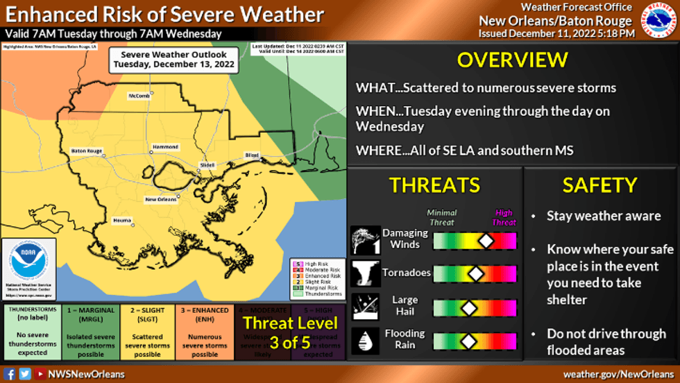
"By late Tuesday and early Wednesday we'll need to start watching for thunderstorms. Storms are mostly likely Wednesday during the daytime as the cold front arrives. A few severe storms look possible with a risk of high winds, hail and/or an isolated tornado."
 NWS
NWS
Malone says Wednesday rain could also be heavy with totals of 2-4 inches expected in spots.
"Much colder air will arrive starting Thursday. A chilly, wintry feel will last through the upcoming weekend with more cold fronts possible into next week."
Detailed Forecast:
TODAY:
Partly to mostly cloudy and a tad cooler. Low: S 62, N 59. High: 71.
TUESDAY:
Mostly cloudy, warm and breezy. 20% chance of a few daytime showers and storms. Low: S 63, N 59. High: 78.
WEDNESDAY:
100% chance of numerous showers and storms from early in the morning into the daytime. Some strong to severe. Mild, humid and breezy. Low: S 67, N 65. High: 77.
THURSDAY:
Mostly sunny to partly cloudy skies. Much cooler. Breezy. Low: S 54, N 50. High: 61.
FRIDAY:
Sunny and chilly. Low: S 48, N 40. High: 58.
SATURDAY:
Partly cloudy and chilly. Low: S 46, N 38. High: 56.
SUNDAY:
Mostly cloudy, breezy and chilly. 20% chance of isolated showers. Lows: S 50, N 40. High: 54.