


After a weekend cold snap, a warming trend is underway.
"We'll have clouds with breaks of sun on Martin Luther King, Jr. Day and temperatures in the low 70s," WWL TV Meteorologist Payton Malone said. "As south winds increase moisture, a couple of stray showers could form although most will stay dry."
He says we warm up even more on Tuesday, and a few showers or thunderstorms will be possible especially in the morning as a rain system stalls to our west.
"Wednesday looks similar with a warm and breezy feel along with clouds and a few afternoon showers."
 NWS
NWS
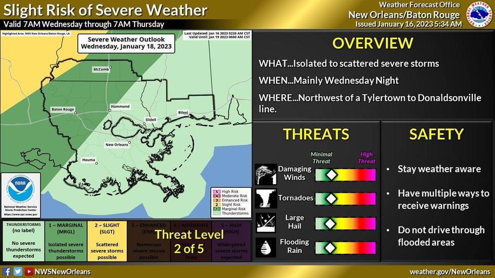
Malone says the line of showers and storms will cross our area late Wednesday night into early Thursday morning.
"A couple of strong storms will be possible, but we'll already be drying out Thursday late morning to midday. "
Detailed Forecast...
TODAY:
Partly to mostly cloudy. Warmer, a bit breezy. High: 72. Wind S 8-15 mph.
TUESDAY:
Clouds and sunshine. 30% chance of spotty showers. Warm, humid, breezy. Low: S 64, N 62. High: 77. Wind S 8-15 mph.
WEDNESDAY:
Partly to mostly cloudy. 20% chance of spotty showers, some storms. Warm, breezy. Low: S 64, N 62. High: 78.
THURSDAY:
60% chance of rain in the early morning, then partly to mostly cloudy. Turning less humid. Breezy. Low: S 59, N 59. High: 70.
FRIDAY:
Sun to partly cloudy. Pleasant. Low: S 50, N 43. High: 63.
SATURDAY:
Mostly cloudy. 50% chance of showers and a few thunderstorms. Low: S 52, N 47. High: 62.
SUNDAY:
Mostly cloudy and breezy. 30% chance of showers. Lows: S 54, N 52. High: 62.


