UPDATE: 2/23/22 @ 7:15 P.M
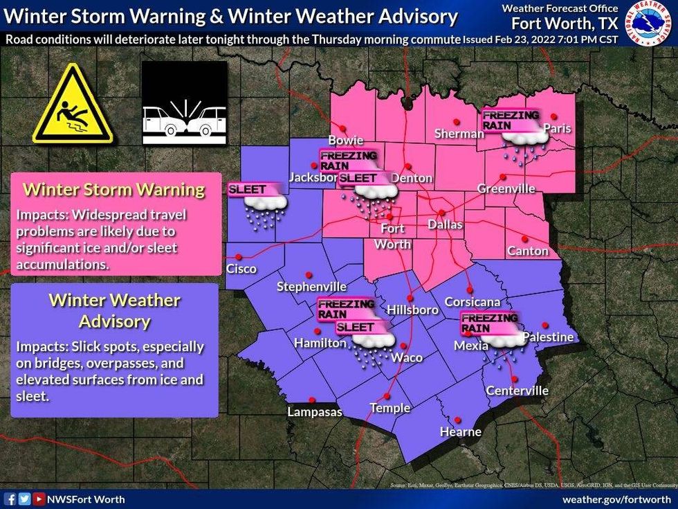
Winter Storm Warning has been expanded to include 4 counties to the east of Dallas and north of I-20.
Also, radar is starting to show freezing drizzle redeveloping over us right now. This will quickly increase in coverage and intensity and freezing rain and some thunder sleet (after 3 am) will start to fall over the next few hours lasting through noon Thursday. Up to a quarter-inch of ice is expected to build upon all roadways overnight through noon Thursday.
 NWS
NWS
A Winter Storm Warning is in effect until 6 p.m. Thursday for DFW and points north. A Winter Weather Advisory is in effect for surrounding areas until 6 p.m. Thursday as well.
Freezing rain with embedded sleet picks up late Wednesday evening through noon Thursday. Temperatures will hold steady in the mid to upper 20s all night long. All roads in the warning area will be ice-covered by Thursday morning, and remain that way through noon Thursday. We may sneak slightly above freezing by Thursday afternoon, melting a lot of the ice on the main roadways.
Skies will clear Thursday night and temperatures will plummet into the upper teens to low 20s by daybreak Friday morning, under a clear sky. There will be areas of patchy ice around. The good news is, we'll be in the low 40s with plenty of sunshine Friday afternoon. The ice will be all gone, except in shady areas, by late morning.
Clouds will increase Friday afternoon ahead of our next weather maker. An upper-level disturbance will cause chilly rain to start breaking out Saturday morning. It's not out of the question that some sleet pellets will mix in with the rain before noon.
Temperatures will be near freezing Saturday morning. As of now, I'm not concerned about icy roadways again. Light rain will continue off and on through the day Saturday as temperatures struggle to reach 40 degrees.
By Sunday and into early next week, a rapid warm-up will take place. Heck, we'll be in the sixties on Monday and Tuesday!
*Tuesday Rain: 0.44"; *Tuesday High: 71; Low: 32
*Today's Averages: High: 63; Low: 42
*Record high: 88 (2017); Record low: 16 (1901)
*February rain: 1.93"; February deficit: 0.14"
*2022 Rain: 2.01"; 2022 deficit: 2.59"
*Sunrise: 7:03am; Sunset: 6:20pm
*Winter Storm Warning until 6pm Thursday, DFW -> north*
*Winter Weather Advisory until 6pm, surrounding areas.
Wednesday: Cloudy, windy and cold. Pockets of light freezing rain/freezing drizzle and sleet. High: Steady in the mid to upper 20s. Wind: North 15-25 mph.
Wednesday night: Cloudy and cold. Moderate freezing rain and pockets of sleet. Low: 23-27. Wind: North 10-15 mph.
Thursday: Moderate freezing rain through mid afternoon. Cloudy and cold. High: Near 30.25-30. Wind: North 15-25 mph.
Thursday night: Clearing and VERY cold. Low: 18-23.
Friday: Increasing clouds and chilly. High: Low 40s.
Saturday: Cloudy and continued cold. Morning rain, possible mixed with sleet, then a chilly afternoon light rain. Cold. High: Upper 30s.
Sunday: Decreasing clouds and warmer. High: Low 50s.
Monday: Sunny and perfect. High: Low 60s.
Tuesday: Sunny and nice. Mid 60s.
LISTEN on the Audacy App
Sign Up and Follow NewsRadio 1080 KRLD