
GOOD MORNING, NORTH TEXAS! OUR COOLEST MORNING OF FALL!
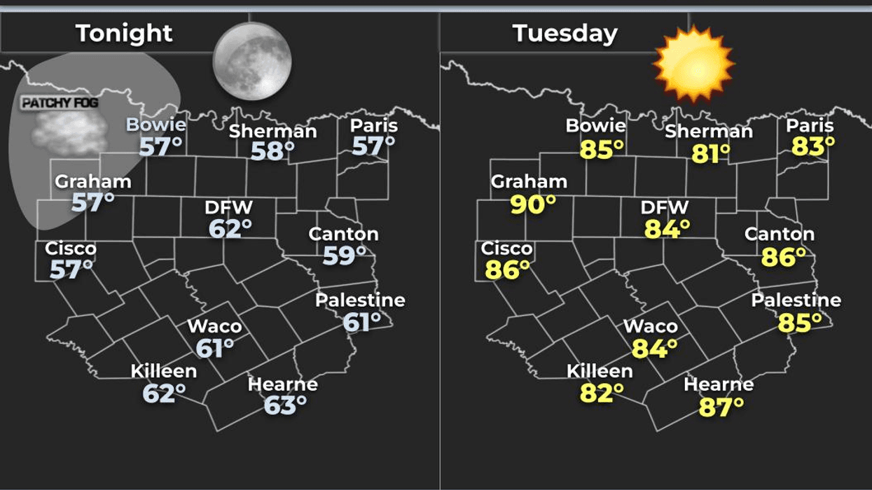
We’re waking up to our coolest morning of the fall season so far here across North Texas! Temperatures have fallen into the upper 50s to low 60s under mostly clear skies.
And if you get a chance before sunrise, look toward the eastern horizon! You’ll see a beautiful crescent moon with Jupiter tucked right next to it. What a gorgeous celestial sight!
Good morning, my friends! Welcome to Tuesday! I hope you can get outside and take a little walk before heading off to work. It is an absolutely beautiful morning!
TODAY'S WEATHER:
- - Morning temperatures: Upper 50s to low 60s
- - Mostly sunny skies
- - Afternoon highs: Middle 80s
- - Low humidity and a beautiful day to be outdoors
And that's pretty much the weather pattern we're going to see for the next seven days.
WHY THE WEATHER STAYS WARM:
High pressure and sinking air will dominate our weather over the next several days. That sinking air compresses and warms the atmosphere while also keeping clouds and thunderstorms from developing.
It also acts like a roadblock, preventing any significant cold fronts from making it into North Texas.
So, for the next week, what you feel is pretty much what you get! Expect highs mainly in the middle 80s, including Columbus Day next Monday.
Morning lows will generally stay in the 60s, and we may see a little more cloud cover this weekend.
EYES ON THE TROPICS!
I’m also keeping a close eye on the tropics down in the Gulf. The Hurricane Center is monitoring an area of disturbed weather in the Gulf with an 80% chance of developing into a tropical depression over the next 48 hours.
If it develops, it could eventually become Tropical Storm Isaias (ees-ah-EE-ahs) — and yes, I'm sure we're going to butcher that name a few times!
There is even a possibility this system could strengthen into a hurricane, so we'll see what happens as we head toward the weekend and early next week.
The good news for the Texas Coast is that even if this system does develop, it is not currently expected to have a significant direct impact. The main concern could be dangerous rip currents and higher surf later this week.
But from Louisiana all the way to the Florida Panhandle, this is an area I'll be watching very closely.
Otherwise, folks, enjoy this beautiful stretch of weather across North Texas!
- Get outside.
- Soak up some sunshine.
- And if you can, enjoy that lunch break outdoors!
Have a GREAT Tuesday, everybody!
— Dan the Weatherman
7-Day Headlines:- * DFW Airport reached 86 on Monday
- * A dry seven days ahead
- * Above average temperatures through the weekend
- * Low humidity/light wind
- * Watching the Gulf for possible tropical development late week
- * Please download our Audacy app. Listen to NewsRadio 1080am live anytime/anywhere
Almanac:
- *Yest Rain: 0.00”; Yest High: 86; Low: 66
- *Today’s Averages: High: 82; Low: 61
- *Record high: 97 (2019); Record low 43 (1915)
- *October rain: 3.84”; Surplus: 3.31”
- *2026 Rain: 26.62”; Snow: 2.4” Deficit: <1.18”>
- *Sunrise: 7:27am; Sunset: 7:05pm
Forecast:
Tuesday: Sunny and warm. Low humidity. High: Mid 80s. Wind: NE 5 mph.
Tuesday night: Clear and cool. Low: Low 60s. Wind: Calm.
Wednesday: Sunny and warm. Low humidity. High: Mid 80s. Wind: Calm.
Thursday: Sunny and warm. High: Mid 80s.
Friday: More of the same. Sunny and warm. High: Upper 80s.
Weekend: Partly cloudy and warm. Slightly higher humidity. Highs: Mid 80s.
Columbus Day: Partly cloudy and warm. High: Upper 80s.
LISTEN on the Audacy App
Tell your Smart Speaker to "PLAY 1080 KRLD"
Sign Up to receive our KRLD Insider Newsletter for more news
Follow us on Facebook | Twitter | Instagram | YouTube