Clouds returning, rain back in the forecast tomorrow, cool temperatures through Wednesday, a rapid warm-up through Saturday, strong storms late into the weekend and another cold front. Welcome to April in North Texas!
Good morning my friends. Happy Monday! I hope you enjoyed the nice cool weekend! We're waking up this morning to increasing cloud cover and cool temperatures once again. Readings range between 44° and 52° across the area. A light jacket will be necessary. Clouds will continue to thicken up today with highs struggling to get above 70°.
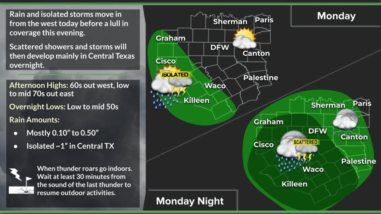
Right now, rain in the Hill Country will slowly move toward North Texas through the day. By this time tomorrow morning, moderate rain will cover all of North Texas. Please allow extra time to reach your final destinations Tuesday morning. A light jacket will be necessary as temperatures fall into the upper 50s.
On and off rain is in the forecast tomorrow, especially the first half of the day with afternoon highs only in the low to mid 60s. Rainfall totals will be less than a half of an inch across the area with isolated heavier totals to our South.
We'll see a slow decrease in clouds on Wednesday with highs creeping back up into the 70s. South winds will start to pick up and the warm up will continue through the end of the week and into the first part of the weekend.
Morning clouds afternoon sun Thursday through Saturday. Highs will be near 80° on Thursday, shooting into the upper 80s on Friday and Saturday.
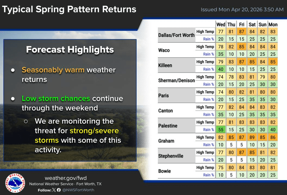
This weekend's forecast is tricky. Data is all over the place trying to figure out when our next cold front arrives. Right now, it suggests it'll move through here late Saturday into Sunday morning bringing an area of strong to severe storms with it. I'll keep an eye on things for you and keep you posted as we evolve through the week.
In the meantime, enjoy the rain tomorrow and the weather when you can, it's the only weather you've got!
7-Day Headlines:
- DFW Airport reached 72 on Thursday.
- Increasing clouds today
- Waves of rain tonight and Tuesday
- Tuesday stays in the 60s
- < 0.50” of rain through Tuesday evening
- Wednesday - Friday looks dry, with warming temperatures
- Storms and a cold font this weekend
- Download our AUDACY app. Listen to KRLD at home!
Almanac:
- Yest Rain: 0.00”; Yest High: 72; Low: 44
- Today’s Averages: High: 77; Low: 56
- Record high: 94 (1925); Record low 40 (1953, 2021)
- April rain: 3.17”; Surplus: 1.27”
- 2026 Rain: 8.33”; Snow: 2.4” Deficit: <2.16”>
- Sunrise: 6:51am; Sunset: 8:03pm
Forecast:
- Monday: Increasing clouds and pleasant. Slight chance of showers by evening. High: Near 70. Wind: SE 5-10 mph.
- Monday night: Cloudy and cool. Light to moderate rain moves in. Low: Upper 50s. Wind: SE 5-10 mph.
- Tuesday: Cloudy and cool. Off and on rain. Nothing severe. High: Mid 60s.
- Wednesday: Mostly to partly cloudy and nice! High: Mid to upper 70s.
- Thursday: Partly cloudy, warm and breezy. High: Near 80.
- Friday: Morning clouds, afternoon sun. Very warm. High: Upper 80s.
- Saturday: Morning clouds, some afternoon sun. Scattered storms late. High: Upper 80s.
- Sunday: Possible morning cold front. Storms move out. Breezy and cooler. High: Near 70.