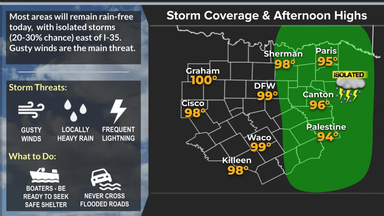

Well, it's looking mainly dry across North Texas through Saturday. We'll have a few isolated late-day showers and thunderstorms today, again on Thursday and Friday, and into Saturday, but the better rain chances arrive Sunday and Monday. Unfortunately, the heat isn't going anywhere—after all, it is summertime.
Good morning, and welcome to Wednesday! We're waking up to temperatures between 75° and 80° under mostly clear skies. Yesterday, DFW Airport reached 100°, the first triple-digit temperature of the year. We may do it again today, as well as Thursday and Friday.
We'll cool off just a bit this weekend, with highs in the upper 90s on Saturday, mid-90s Sunday and Monday, and back into the upper 90s by Tuesday.
Rain chances remain very limited through Saturday—just a few pesky afternoon and evening showers or thunderstorms, with only about a 20 to 30 percent chance each day. Daytime heating, plenty of moisture, and a weak disturbance will be enough to spark a few isolated storms, but most of North Texas will stay dry.
Our next better opportunity for rain arrives Sunday and Monday, especially along and north of Interstate 20. It's still too early to talk about rainfall totals because, first, you've got to get a storm over your backyard. For now, we'll go with about a 30% chance on Sunday, increasing to around 40% on Monday, before dropping back to 20% on Tuesday.
Those increased rain chances and extra cloud cover should help trim afternoon highs back into the mid-90s to start next week.
I'm Meteorologist Dan Brounoff in the KRLD Weather Center. I hope you have a great Wednesday, and enjoy the weather when you can—it's the only weather you've got!
7-Day Headlines:
- * DFW Airport reached 100 yesterday. First triple of the year!
- * Back near 100 degrees through Friday
- * An isolated late day storm today
- * Cooling off a bit this weekend into nearly next week
- * Scattered late-day storms return Saturday - Tuesday
- * Severity low
- * Download our Audacy app. Listen Live at home or work
Almanac:
- *Yest Rain: 0.00”; Yest High: 100; Low: 477
- *Today’s Averages: High: 95; Low: 75
- *Record high: 107 (1956); Record low: 62 (1952)
- *July Rain: 0.00"; Deficit: <0.69”>
- *2026 Rain: 21.25"; Surplus: 0.27”
- *Sunrise: 6:27am; Sunset: 8:39pm
Forecast:
Wednesday: Mostly sunny and hot. An isolated late-day shower or storm. High: Near 100. Heat index 104. Wind: SSW 5-10 mph.
Wednesday: Clear, mild and muggy. Low: Upper 70s. Wind: SSE 5-10 mph.
Thursday: Sunny, breezy and hot. High: Near 100. Heat index: 104. Wind: SSW 10-20 mph
Friday: Sunny, breezy and hot. High: Upper 90s. Heat index: 103.
Saturday: Partly cloudy and hot. Isolated late-day showers and storms. High: Mid 90s.
Sunday: Partly cloudy and hot. Isolated late-day showers and storms. High: Mid 90s.
Monday: Partly cloudy and hot. Scattered late-day showers and storms. High: Mid 90s.
Tuesday: Partly cloudy and hot. Scattered late-day showers and storms. High: Upper 90s.
LISTEN on the Audacy App
Tell your Smart Speaker to "PLAY 1080 KRLD"
Sign Up to receive our KRLD Insider Newsletter for more news
Follow us on Facebook | Twitter | Instagram | YouTube