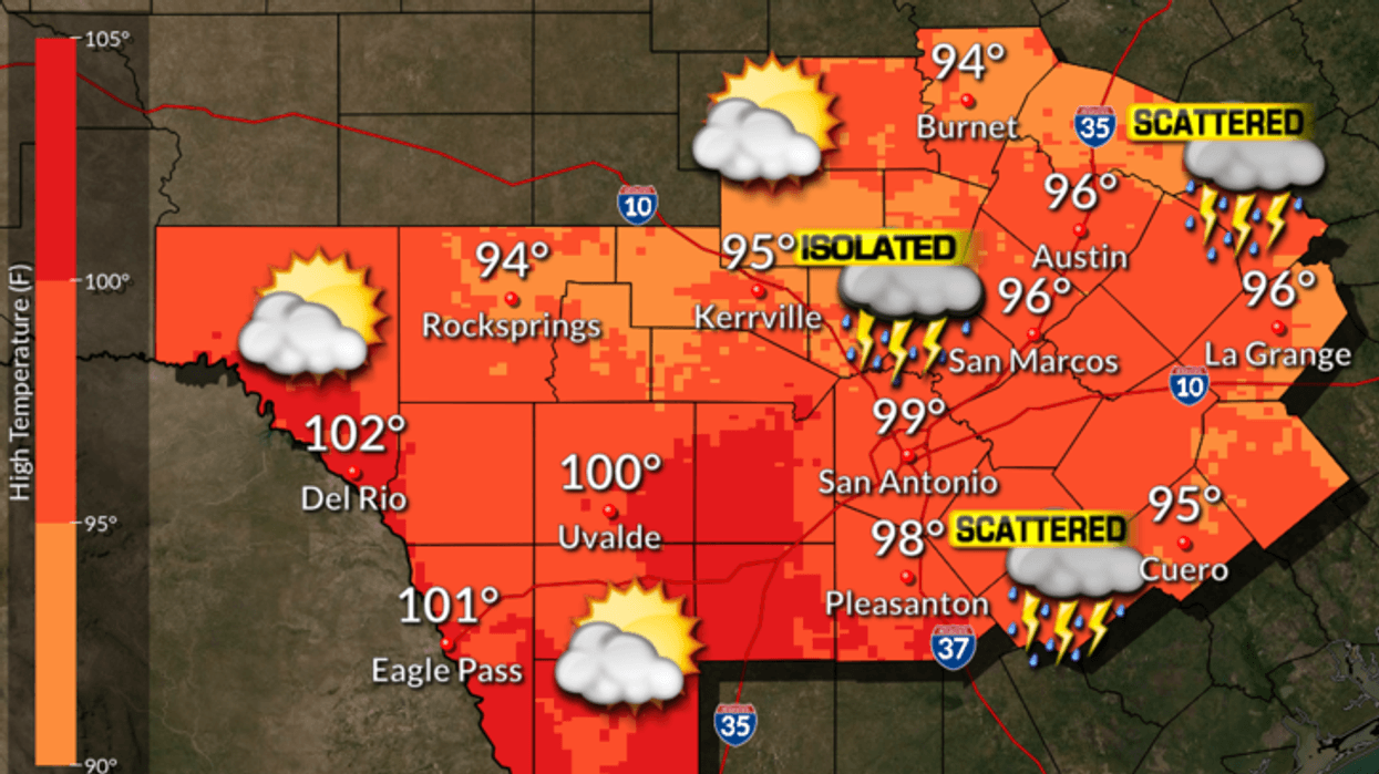
AUSTIN (Talk1370.com) -- As Laura nears landfall on the Texas-Louisiana border, the Austin area will see minimal impacts from the storm.
Wednesday will see scattered showers and storms throughout the day on Wednesday, with the best chances east of the Interstate 35 corridor. With the added cloud cover, highs will reach into the upper 90s.
Scattered showers and storms will remain in the forecast Wednesday night as Laura makes landfall, with lows in the upper 70s.
Here's a look at the extended forecast:
THURSDAY...Partly cloudy. Slight chance of showers in the morning, then a slight chance of showers and thunderstorms in the afternoon. Highs in the upper 90s. Northwest winds 5 to 10 mph. Chance of rain 20 percent. Highest heat index readings up to 106 in the afternoon.
THURSDAY NIGHT...Mostly clear with a 20 percent chance of showers and thunderstorms. Lows in the mid 70s. South winds 5 to 10 mph.
FRIDAY...Mostly sunny. A 20 percent chance of showers and thunderstorms in the afternoon. Highs around 101. South winds 5 to 10 mph. Highest heat index readings up to 112 in the afternoon.
FRIDAY NIGHT...Mostly clear. Lows in the upper 70s.
SATURDAY...Mostly sunny in the morning then becoming partly cloudy. Highs around 100.
SATURDAY NIGHT...Mostly clear. Lows in the mid 70s.
SUNDAY...Partly cloudy. A 20 percent chance of showers and thunderstorms in the afternoon. Highs in the upper 90s.
SUNDAY NIGHT...Partly cloudy. Lows in the upper 70s.
MONDAY...Partly cloudy with a 20 percent chance of showers and thunderstorms. Highs in the upper 90s.
MONDAY NIGHT AND TUESDAY...Partly cloudy. Lows in the upper 70s. Highs in the upper 90s.