
Waves of lake effect snow are in the late week forecast for much of Western New York in advance of a weekend that will bring a round of dangerously cold temperatures, and even more snow to the region.
"There is a lot to digest the next 4 or 5 days, a lot of active weather," National Weather Service meteorologist Jon Hitchcock tells WBEN.
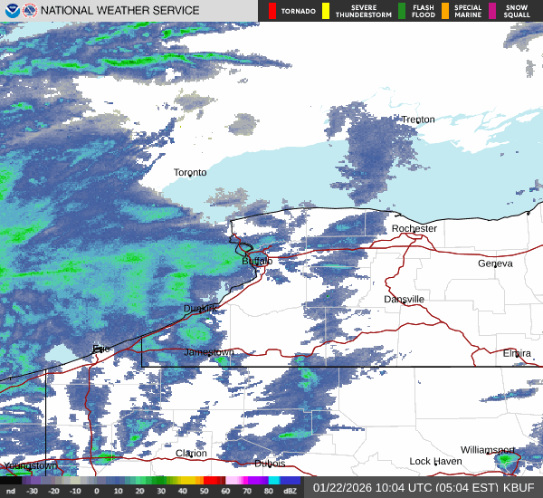
First up is an area of widespread snow that will impact the Thursday morning commute. "That's going to produce a few inches area-wide across all of Western New York," Hitchcock cautions.
A Winter Weather Advisory is posted for the region through 1 p.m. Friday.
After a midday reprieve, additional lake effect snow will develop south of the Buffalo metro area, across the southtowns, Boston Hills and Wyoming County through Friday morning. "After all is said and done, we may see up to a foot, or even just over a foot of snow in the southern half of Erie County."
A Lake Effect Snow Warning is posted for southern Erie and Wyoming County until 1 p.m. Friday as well.

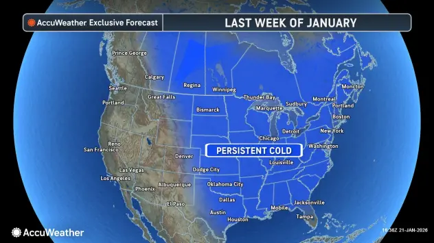
The weekend kicks off very cold and dry for Saturday.
"The coldest air of the season is coming in later tomorrow afternoon through Saturday," Hitchcock says. "Highs only in the single numbers Saturday, wind chills well below zero Friday through Saturday."
An expansive weekend storm that will impact much of the nation will make its presence known across the Niagara Frontier late Saturday night and Sunday morning, continuing into Monday. "That could produce widespread and significant snowfall across the region," Hitchcock says.
A Winter Storm Watch is posted area-wide Sunday into Monday.
"We're likely to be in the swatch of heavy snow," Hitchcock says of the late weekend storm system that will impact much of the eastern half of the country. "It could be pretty impactful snow Sunday, into at least the first half of Monday."
Related

WINTER WEATHER ADVISORY REMAINS IN EFFECT UNTIL 1 PM EST FRIDAY...
WINTER STORM WATCH IN EFFECT FROM LATE SATURDAY NIGHT THROUGH MONDAY EVENING
* WHAT...Lake effect snow and blowing snow. Additional snow accumulations 4 to 9 inches in the most persistent lake snows south and east of Buffalo to southwest Genesee County, with 2 to 4 inches across the rest of the area. Winds gusting as high as 40 mph will produce blowing and drifting snow.
Widespread heavy snow possible late Saturday night through Monday evening. Significant accumulations possible.
* WHERE...Northern Erie and Genesee Counties. The greatest accumulations will be just south and east of Buffalo to southwest Genesee County during the lake effect snow today through Friday.
* WHEN...For the Winter Weather Advisory, until 1 PM EST Friday. For the Winter Storm Watch, from late Saturday night through Monday evening.
* IMPACTS...Travel will be difficult at times with snow covered roads and poor visibility. The hazardous conditions will impact the Thursday morning and evening commutes.
WINTER WEATHER ADVISORY REMAINS IN EFFECT UNTIL 10 AM EST THIS MORNING
WINTER STORM WATCH IN EFFECT FROM LATE SATURDAY NIGHT THROUGH MONDAY EVENING
* WHAT...Snow and blowing snow. Additional snow accumulations 1 to 3 inches. Winds gusting as high as 35 mph will produce blowing and drifting snow in open areas.
Widespread heavy snow possible late Saturday night through Monday evening. Significant accumulations possible.
* WHERE...Niagara, Orleans, and Allegany Counties.
* WHEN...For the Winter Weather Advisory, until 10 AM EST this morning. For the Winter Storm Watch, from late Saturday night through Monday evening.
* IMPACTS...Plan on snow covered and slippery road conditions with reduced visibility. The hazardous conditions will impact the Thursday morning commute.
LAKE EFFECT SNOW WARNING REMAINS IN EFFECT UNTIL 1 PM EST FRIDAY...
WINTER STORM WATCH IN EFFECT FROM LATE SATURDAY NIGHT THROUGH MONDAY EVENING
* WHAT...Heavy lake effect snow and blowing snow today through Friday. Additional snow accumulations 8 to 14 inches in the most persistent lake snows. Winds gusting as high as 40 mph will produce significant blowing and drifting snow.
Widespread heavy snow possible late Saturday night through Monday evening. Significant accumulations possible.
* WHERE...Wyoming and Southern Erie Counties.
* WHEN...For the Lake Effect Snow Warning, until 1 PM EST Friday.
For the Winter Storm Watch, from late Saturday night through Monday evening.
* IMPACTS...Travel will be very difficult with snow covered roads and very poor visibility at times. The hazardous conditions will impact the Thursday morning and evening commutes.
WINTER WEATHER ADVISORY REMAINS IN EFFECT UNTIL 1 PM EST FRIDAY...
WINTER STORM WATCH IN EFFECT FROM LATE SATURDAY NIGHT THROUGH MONDAY EVENING
* WHAT...Lake effect snow and blowing snow. Additional snow accumulations 4 to 8 inches in the most persistent lake snows.
Winds gusting as high as 40 mph will produce blowing and drifting snow.
Widespread heavy snow possible late Saturday night through Monday evening. Significant accumulations possible.
* WHERE...Chautauqua and Cattaraugus Counties. The greatest accumulations will focus across western Chautauqua and far northwest Cattaraugus counties.
* WHEN...For the Winter Weather Advisory, until 1 PM EST Friday. For the Winter Storm Watch, from late Saturday night through Monday evening.
* IMPACTS...Travel will be difficult with snow covered roads and poor visibility. The hazardous conditions will impact the Thursday morning and evening commutes.