
Buffalo, N.Y. (WBEN) - The countdown to New Year's Eve and ringing in 2026 includes a round of lake effect snow for the Buffalo metro area that will likely impact revelers gathering for festivities in downtown Buffalo.
A Winter Storm Warning has been expanded to include the metro Buffalo area through early New Year's Day for northern Erie and Genesee counties, and continuing through early Friday for southern Erie County and the southern tier. A Winter Weather Advisory is posted through early New Year's Day for Niagara and Orleans counties.
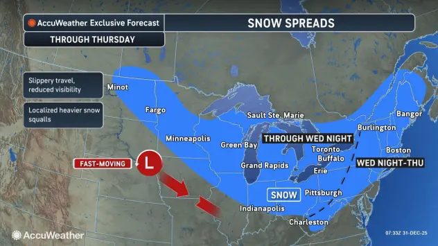
The lake effect snow that has been targeting the far southern tier will begin to move northward through the day Wednesday, National Weather Service meteorologist John Hitchcock tells WBEN.
"It will reach the Buffalo metro area this afternoon, probably by early to mid-afternoon, moving from south to north," Hitchcock says. "It will stay in the Buffalo area through the afternoon and early evening."
Hitchcock predicts the snow intensity, especially across the southtowns, will be quite heavy during the afternoon and evening hours. "The timeframe from 2 p.m. this afternoon to 8 p.m. this evening is going to be rough"
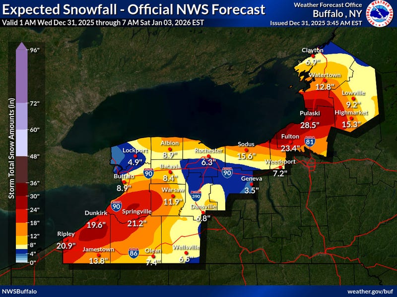
Expect 6-12 inches of accumulation, with the greatest amounts from the Buffalo southtowns to western Genesee County. Snowfall rates may reach 2 inches per hour at times this afternoon through this evening.
The snow band will then begin to move quickly southward again during the later evening hours, back to the southern tier.
There is some good news for ball drop revelers, once they get to downtown Buffalo for the celebration. "By the time we get to the ball drop hour, mainly dry in the Buffalo metro area, maybe just a few scattered light flurries," Hitchcock says.
Dress warmly, however, with wind chills in the single digits by midnight.
WINTER STORM WARNING IN EFFECT FROM 1 PM THIS AFTERNOON TO 1 AM EST THURSDAY
* WHAT...Heavy snow expected. Total snow accumulations 6 to 12 inches.
* WHERE...Northern Erie County. The greatest accumulations will be across the Buffalo Southtowns.
* WHEN...From 1 PM this afternoon to 1 AM EST Thursday.
* IMPACTS...Travel will be very difficult with snow covered roads and poor visibility. The hazardous conditions will impact the Wednesday morning and evening commutes.
PRECAUTIONARY/PREPAREDNESS ACTIONS...
Widespread accumulating snow will create dangerous travel conditions.
Submit snow reports through our website or social media.
During lake effect snow, the weather can vary from bands of locally heavy snow with greatly reduced visibilities to dry conditions just a few miles away. Be prepared for rapid changes in weather, visibility, and road conditions.
WINTER WEATHER ADVISORY REMAINS IN EFFECT UNTIL 1 AM EST THURSDAY
* WHAT...Lake effect snow. Additional snow accumulations 3 to 6 inches in the most persistent lake snows. Winds gusting as high as 35 mph.
* WHERE...Niagara, Orleans, and Monroe Counties.
* WHEN...Until 1 AM EST Thursday.
* IMPACTS...Travel will be difficult at times with poor visibility and snow covered roads.
PRECAUTIONARY/PREPAREDNESS ACTIONS...
During lake effect snow, the weather can vary from bands of locally heavy snow with greatly reduced visibilities to dry conditions just a few miles away. Be prepared for rapid changes in weather, visibility, and road conditions.
WINTER STORM WARNING REMAINS IN EFFECT UNTIL 1 AM EST FRIDAY
* WHAT...Heavy snow. Additional snow accumulations 1 to 2 feet.
* WHERE...Wyoming, Chautauqua, Cattaraugus, and Southern Erie Counties. The greatest accumulations will be across the Chautauqua Ridge, Boston Hills, and western Wyoming County.
* WHEN...Until 1 AM EST Friday.
* IMPACTS...Travel will be very difficult with snow covered roads and very poor visibility. The hazardous conditions will impact the Wednesday morning and evening commutes.
PRECAUTIONARY/PREPAREDNESS ACTIONS...
Widespread accumulating snow will create dangerous travel conditions.
Related
