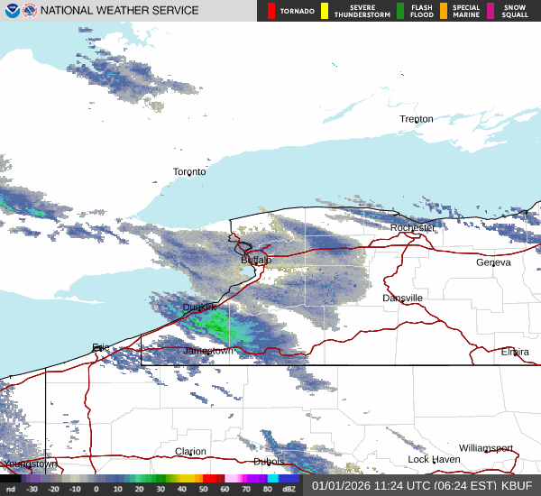

Buffalo, N.Y. (WBEN) - The lake-enhanced snow has shifted well to the south of Buffalo into the southern tier, leaving many across the metro area digging out from a New year's Eve snowfall totaling more than a foot in spots.
The following are snowfall observations from the National Weather Service in Buffalo as of late New Year's Eve.
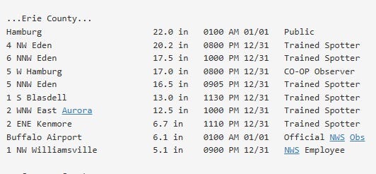
The dry conditions across the region will allow those who live in places like Hamburg, East Aurora and Orchard Park, where as much as 22 inches of snow fell, to dig out on New Year's Day.
The heavy lake effect snows will focus southeast of the lake across the ski country through Friday with varying intensity and placement. The lake snows will finally weaken over the weekend, NWS forecasters say.
A weather system will return moisture back to the region tonight and reinvigorate the lake snows. This will focus a band of heavy lake snow from southern Erie county into the western Southern Tier. Amounts here on the order of 3-6 inches are possible, but localized heavier amounts are certainly possible.
Lake snow will be far less impressive off Lake Erie Friday and into the weekend. Following a brief resurgence Thursday night through early Friday morning, expect a general weakening trend Friday through Friday night. Additional accumulations will be on the order of a few inches across the higher terrain of the western Southern Tier and Boston Hills, with most of that falling during the first half of Friday. What remains of the lake effect snow will gradually diminish and end Friday night through Saturday.
Other than a few light snow showers across the metro Buffalo region through the weekend, the weather will be calm.
Looking ahead to next week, a notable warming trend is expected through the middle of the week, with highs well above the freezing mark by Wednesday.
WINTER STORM WARNING REMAINS IN EFFECT UNTIL 10 PM EST FRIDAY
* WHAT...Heavy lake effect snow. Additional snow accumulations 6 to 12 inches.
* WHERE...Wyoming, Chautauqua, Cattaraugus, and Southern Erie Counties. The greatest additional accumulations will be across the Chautauqua Ridge and Boston Hills.
* WHEN...Until 10 PM EST Friday. The majority of the additional snowfall will be tonight through early Friday.
* IMPACTS...Travel will be very difficult with snow covered roads and poor visibility at times.
PRECAUTIONARY/PREPAREDNESS ACTIONS...
Widespread accumulating snow will create dangerous travel conditions.