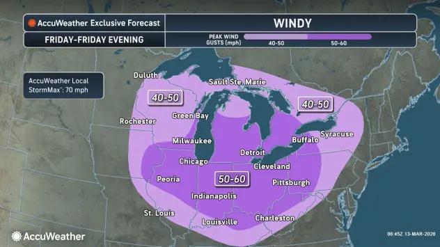

A wave of extreme wind will move into the Western New York region to kickoff the weekend Friday, with a High Wind Warning posted for the Niagara Frontier and gusts of 55 to 60 mph in the forecast.
The highest wind gusts will be mainly through Friday afternoon for most of the region, with the strongest winds expected along the Lake Erie shoreline.
"We're in a bit of a roller coaster these days, with snow and rain, and then warmer temperatures and colder temperatures," National Weather Service meteorologist Heather Kenyon tells WBEN. "That's going to continue."
An area of widespread snow will overspread the region Friday. "We're not looking for much accumulation," Kenyon says. "It might actually mix with some rain...with highs in the 40's."
The strong winds resulting from a cold front system will deliver more colder air for the weekend.
"We are expecting accumulating snow tonight, mainly across the higher terrain, where we could see 4 to 7 inches," Kenyon cautions. "Again, mainly on the higher terrain, southern Erie, Wyoming, Chautauqua and Cattaraugus counties."
A Winter Weather Advisory is posted for southern Erie, Wyoming, Chautauqua and Cattaraugus counties.
The metro Buffalo area is not in the clear as far as snow accumulation is concerned, Kenyon warns. "Tonight, it looks like we could pick up around 1 to 3 inches across the metro, City of Buffalo."
HIGH WIND WARNING REMAINS IN EFFECT FROM NOON TODAY TO 5 AM EDT SATURDAY
* WHAT...Southwest winds 25 to 35 mph with gusts up to 60 mph expected.
* WHERE...The Niagara Frontier.
* WHEN...From noon today to 5 AM EDT Saturday.
* IMPACTS...Strong winds will blow down trees and power lines.
Scattered power outages are expected. Travel will be difficult, especially for high profile vehicles.
WINTER WEATHER ADVISORY IN EFFECT FROM 5 PM THIS AFTERNOON TO 8 AM EDT SATURDAY
* WHAT...Snow expected. Total snow accumulations 4 to 7 inches across the higher terrain. 1 to 2 inches expected for the lower elevations. Winds gusting as high as 60 mph will produce blowing and drifting snow, mainly overnight when temperatures fall into the 20s.
* WHERE...Wyoming, Chautauqua, Cattaraugus, and Southern Erie counties.
* WHEN...From 5 PM this afternoon to 8 AM EDT Saturday.
* IMPACTS...Travel will be difficult. Impacts will be after the evening commute. Strong winds will cause tree damage and possible power outages.
PRECAUTIONARY/PREPAREDNESS ACTIONS...
Periods of snow will result in snow covered roads and limited visibilities. Slow down and use caution while driving.