
Buffalo, N.Y (WBEN) - It really should be no surprise to hearty Buffalonians that the weather is set to take yet another turn.
For the colder.
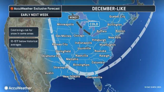
"It's looking like we're going to get our first real taste of winter early next week," National Weather Service meteorologist Phillip Pandolfo tells WBEN.
Before the colder air and potential for snow, there will be a couple batches of wind and rain Friday and Sunday.
"It's behind that Sunday system that we're going to see a much colder air mass wrap right around the lakes," Pandolfo forecasts. "And it will stick around for at least a couple of days."
The temperature swing will be very noticeable, Pandolfo says, with temps nearing 60 at the start of the weekend before the weather system takes hold. "By Monday we'll see high temperatures struggling to get out of the mid 30's."
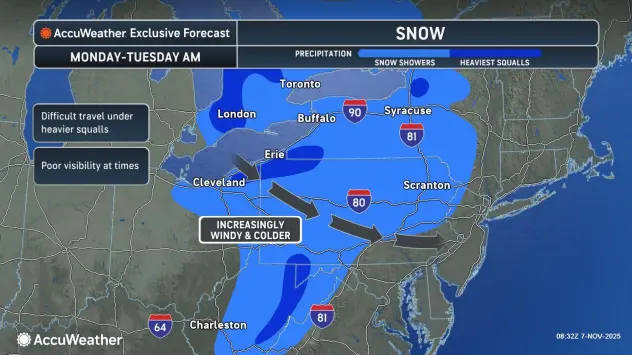
Lake Effect Setup
As is usually the case with lake effect snow, the setup is complicated and will be dictated by temperature and wind direction, Pandolfo cautions.
"We are going to be looking at the changeover from rain to snow beginning Sunday night as that colder air wraps in," Pandolfo says. Any snow will be pretty light at the onset, however, with the initial targets to be southeast of the lake in the general ski country.
There will be a wind shift to more westerly and southwesterly as Tuesday approaches, however moderating temperatures at that point may spare the metro Buffalo area from lake effect snow that would transition to more rain.
The metro Buffalo area could see a dusting in spots, with temperatures being quite cold after sunset. Temps will drop to the 20's during the overnight hours early next week, Pandolfo notes.
"It does seem like the heaviest snowfall is going to be south of the City of Buffalo. Could see some in the southtowns, though the greatest risk is going to be more near the ski country."