
Buffalo, N.Y. (WBEN) - A dry, quiet and cold Saturday will preced yet anoyher swing in the winter weather across the Buffalo-Niagara region Sunday.
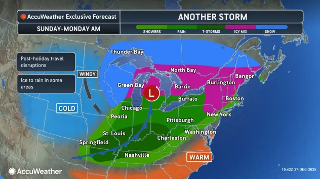
A moisture-ladened weather system will cross the eastern Great Lakes late Sunday through early Monday, with a widespread soaking rain, which may start as some freezing rain in some spots.
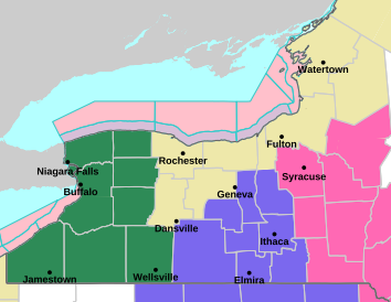
A Flood Watch is posted for ALL of Western New York
Forecasters at the National Weather Service say rainfall up to 1.5 inches could fall Sunday into Monday.
"We expect widespread, heavy rainfall to develop during the day tomorrow(Sunday), especially in the afternoon and evening," National Weather Service meteorologist John Hitchcock tells WBEN.
While there is little in the way of snow pack across the lower terrain areas, the amount of rain on top of snowmelt from the higher elevations could push several creeks and rivers to near flood stage.
The window for this occurrence for the Buffalo area creeks would be Sunday afternoon through late Monday, when falling temperatures below freezing slows runoff and allows creek and river levels to begin to fall.
For those heading to the Bills-Eagles game Sunday afternoon at Highmark Stadium, it will be a soggy experience. "We expect widespread, soaking rainfall, and temperatures in the 40's," Hitchcock tells us.
As the weather system`s warmer air encroaches on the region, there is a small, brief window for a wintry mix across WNY at the onset of precip Sunday afternoon, forecasters say.
Lakeshore flood potential also exists Monday and Monday night as strong winds are expected on the lakes.
Lake Effect Snow
Much colder air will fill-in across the region Monday afternoon, setting up the potential for some significant lake effect snow potential.
Initially, winds will be southwesterly, which will likely cause the bands to form over the Niagara Frontier in the afternoon. Winds are expected to shift relatively quickly to westerly and then northwesterly through Monday night, which would place the greatest snowfall accumulations by Tuesday morning off Lake Erie south of Buffalo, into the southtowns and across the ski country.
Gusty Winds
Winds will become a factor Monday afternoon, forecasters say, with southwest to westerly winds gusting into 40 to 50 mph range, and likely higher northeast of Lake Erie in particular.
Southwest gusts early Monday would not be great for trees, especially shallow rooted trees, that may now be situated within a soggy ground. Additionally these winds, combined with the lake effect snow will create blowing and drifting snow, with very poor visibility expected within the lake effect snow bands by Monday evening.
FLOOD WATCH IN EFFECT FROM SUNDAY AFTERNOON THROUGH MONDAY AFTERNOON
* WHAT...Flooding caused by excessive rainfall is possible.
* WHERE...A portion of western New York, including the following counties, Allegany, Cattaraugus, Chautauqua, Genesee, Niagara, Northern Erie, Orleans, Southern Erie and Wyoming.
* WHEN...From Sunday afternoon through Monday afternoon.
* IMPACTS...Excessive runoff may result in flooding of rivers, creeks, streams, and other low-lying and flood-prone locations.
The greatest threat for flooding will be along the Buffalo area creeks. Flooding may occur in poor drainage and urban areas.
* ADDITIONAL DETAILS...
- Widespread rainfall totals of 1-1.5 inches are expected within the watch area. Locally higher amounts are possible.
- http://www.weather.gov/safety/flood PRECAUTIONARY/PREPAREDNESS ACTIONS...
You should monitor later forecasts and be alert for possible Flood Warnings. Those living in areas prone to flooding should be prepared to take action should flooding develop.