
Some spotty and light snow will greet the Western New York region early Sunday, before fading away as temperatures begin to moderate across the Buffalo-Niagara area.
"Our temperatures are really going to start to climb," National Weather Service meteorologist Jim Mitchell tells WBEN. "We may get into the low 50's here as we get into the middle, late afternoon hours."
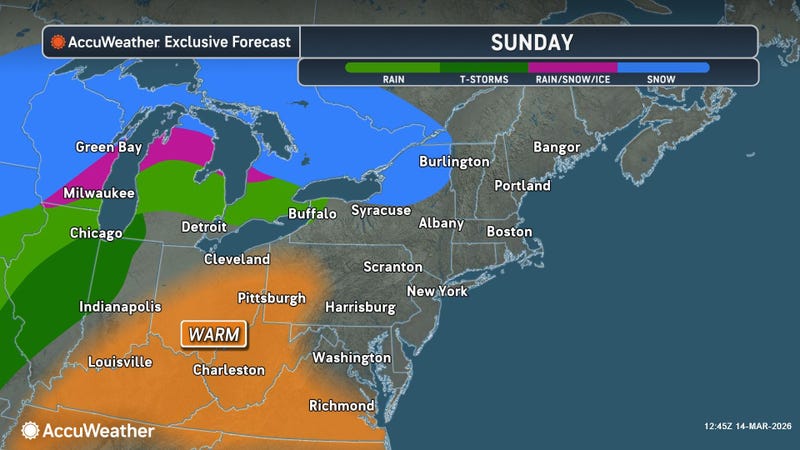
For the Buffalo Saint Patrick's Day Parade, conditions will be dry, temperatures milder, and with some noticeable breeze developing through the afternoon.
"It will become quite breezy as we go through the late afternoon hours," Mitchell cautions.
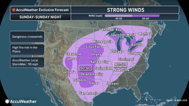
A Wind Advisory is posted for metro Buffalo and the northern portions of Western New York and a High Wind Warning is posted across southern Erie County and the southern tier.
"As we go into this evening, we start to see gusts upwards of 40 to 50 mph overnight," Mitchell says.
Winds will remain strong into Monday as a cold front crosses the region and colder temps return. Showers and even some thunderstorms will accompany the frontal passage.
"We'll see much colder air moving in late tomorrow afternoon, with rain changing over to snow," Mitchell says. Snow will taper overnight into Tuesday, however some lake effect snow will develop across the higher terrain of the southern tier.
WIND ADVISORY REMAINS IN EFFECT FROM 5 PM THIS AFTERNOON TO 8 PM EDT MONDAY
* WHAT...South winds 20 to 30 mph with gusts up to 50 mph expected tonight. Winds will become southwest Monday and gusts 40 to 50 mph are expected.
* WHERE...Niagara, Orleans, Monroe, Wayne, Northern Cayuga, Oswego, Northern Erie, Genesee, Wyoming, Livingston, Ontario, Cattaraugus, and Allegany Counties. The strongest wind gusts will be across the higher terrain of western NY including the Finger Lakes region Sunday night. As winds become southwest Monday, the strongest wind gusts are expected across the Niagara Frontier.
* WHEN...From 5 PM this afternoon to 8 PM EDT Monday.
* IMPACTS...Gusty winds will blow around unsecured objects. Tree limbs could be blown down and a few power outages may result.
PRECAUTIONARY/PREPAREDNESS ACTIONS...
Use extra caution when driving, especially if operating a high profile vehicle. Secure outdoor objects.
HIGH WIND WARNING IN EFFECT FROM 2 PM THIS AFTERNOON TO 8 PM EDT MONDAY
* WHAT...South to southeast winds 25 to 35 mph with gusts up to 60 mph expected through tonight. Winds become southwest Monday morning with gusts up to 50mph.
* WHERE...Chautauqua and Southern Erie Counties. Strongest gusts tonight expected along the northwest downslope region of the Chautauqua Ridge and to the Lake Erie shoreline. Strongest wind gusts Monday will be countywide.
* WHEN...From 2 PM this afternoon to 8 PM EDT Monday.
* IMPACTS...Strong winds will blow down trees and power lines.
Scattered power outages are expected. Travel will be difficult, especially for high profile vehicles.
PRECAUTIONARY/PREPAREDNESS ACTIONS...
Avoid being outside in forested areas and around trees. If possible, remain in the lower levels of your home during the windstorm, and avoid windows. Use caution if you must drive.