
Buffalo, N.Y. (WBEN) - Thunderous and damaging winds have been slamming the Buffalo-Niagara region through the day Monday, leading to tens of thousands of customers without power, as well as localized flooding in spots along the Lake Erie shoreline.
Related

Wind gusts in the 60 to 70 mph range were commonplace throughout the day Monday, with a peak gust of 79 mph reporter at the Buffalo Airport.
"There are going to be numerous numbers that may likely approach or exceed the 80 mph mark once we get the Coast Guard data from the shoreline of Lake Erie," meteorologist Andy Parker told WBEN.
By mid-afternoon Monday, some gradual weakening of the winds is forecast, but still remaining strong at 55-65 mph through Monday night, especially across the Niagara Frontier and nearshore locations.
West to northwest winds Tuesday will likely remain near advisory levels (45- 55 mph) through the afternoon, and High Wind Warnings remain into effect through Monday night with Wind Advisories lingering through Tuesday.
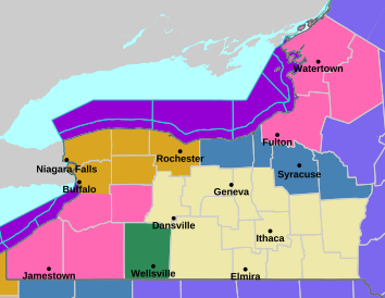
A lengthy list of warnings and advisories are in place across the entire region Monday, including:
-Winter Weather Advisory for the Buffalo-Niagara region
-Winter Storm Warning for southern Erie, southern tier.
-High Wind Warning for all of WNY
-Lakeshore Flood Warning for the Lake Erie shoreline
Lake Effect Snow
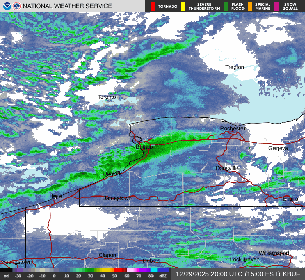
The gusty winds will turn westerly and eventually northwesterly that will shift the lake effect bands into the Southtowns late Monday afternoon and then mainly into the snowbelt areas of southern Erie, southwestern Wyoming, Chautauqua, and Cattaraugus counties through much of Tuesday where Winter Storm Warnings are in place.
Heaviest totals will remain in the most persistent lake bands with lake effect snow, expanding across much of the southern shore of Lake Ontario tonight and continuing southeast of the lake Tuesday.
"Near whiteout conditions at times," Parker says. "It's not a full-on, 'you can't see the front of your car', but at times you are finding these bursts of wind and snow combine to give you those brief whiteout conditions."
The initial forecast calls for 3 to 6 inches of snow across the Buffalo metro, however with the strong winds blowing the snow, any falling snow combined with the wind could cause whiteout conditions at times.
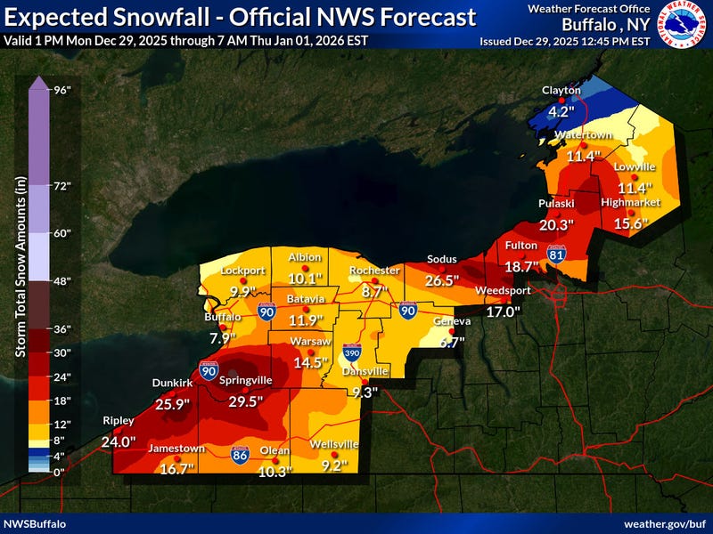
Much heavier snow accumulations are forecast south of the immediate southtowns, as depicted on the NWS Buffalo map below(through Thursday).
Lake Seiche Possible
While our region has had several lake seiches recently to just over 6 feet, a much stronger wind flow is expected to bring a seiche on Lake Erie, potentially to warning levels (8 or 9feet). A Lakeshore Flood Warning has been issued to account for this potential. One factor that may back it tough for lake level rises is the lake level is currently below normal. But given the strength of this system, even the low lake level will still have potential for exceeding warning level. Flooding is possible along Route 5 in Hamburg, Buffalo Harbor and Canalside, Dunkirk Harbor, and other flood prone locations. Flooding could along occur along portions of the Niagara River. Very high wave action may also result in significant shoreline erosion.
HIGH WIND WARNING REMAINS IN EFFECT FROM 4 AM MONDAY TO 1 AM EST TUESDAY
* WHAT...Southwest winds 35 to 45 mph with gusts up to 75 mph expected. The strongest wind gusts will be along the Lake Erie shoreline and near Downtown Buffalo.
* WHERE...Erie, Niagara, Orleans, Monroe, Genesee, Wyoming, and Chautauqua Counties.
* WHEN...From 4 AM Monday to 1 AM EST Tuesday.
* IMPACTS...Damaging winds will blow down trees and power lines.
Widespread power outages are expected. Shallow rooted trees in a saturated ground will be more susceptible to falling. Travel will be extremely difficult, especially for high profile vehicles.
PRECAUTIONARY/PREPAREDNESS ACTIONS...
Avoid being outside in forested areas and around trees. If possible, remain in the lower levels of your home during the windstorm, and avoid windows. Use caution if you must drive.
WINTER WEATHER ADVISORY REMAINS IN EFFECT FROM 10 AM THIS MORNING TO 10 PM EST THIS EVENING
* WHAT...Snow and blowing snow expected. Total snow accumulations 2 to 5 inches in the most persistent lake snows. Winds gusting as high as 75 mph.
* WHERE...Northern Erie and Genesee Counties.
* WHEN...From 10 AM this morning to 10 PM EST this evening.
* IMPACTS...Plan on slippery road conditions and brief periods of whiteout conditions. Areas of blowing snow will significantly reduce visibility. The hazardous conditions will impact the evening commute tonight.
PRECAUTIONARY/PREPAREDNESS ACTIONS...
Periods of snow will result in snow covered roads and limited visibilities. Slow down and use caution while driving.
During lake effect snow, the weather can vary from bands of locally heavy snow with greatly reduced visibilities to dry conditions just a few miles away. Be prepared for rapid changes in weather, visibility, and road conditions.
WINTER STORM WARNING REMAINS IN EFFECT FROM 1 PM THIS AFTERNOON TO 1 AM EST FRIDAY
* WHAT...Heavy snow expected. Total snow accumulations 1 to 3 feet.
Winds gusting as high as 65 mph creating blowing and drifting snow and whiteout conditions.
* WHERE...Wyoming, Chautauqua, Cattaraugus, and Southern Erie Counties.
* WHEN...From 1 PM this afternoon to 1 AM EST Friday.
* IMPACTS...Whiteout conditions are expected and will make travel treacherous and potentially life-threatening. Travel will be very difficult. The hazardous conditions will impact travel through the week.
* ADDITIONAL DETAILS...Lake effect snow is expected oscillate several times downwind of Lake Erie this week. Forecast snowfall amounts could be much higher where lake bands persist during this long duration event. The strongest winds will be today and tonight.
PRECAUTIONARY/PREPAREDNESS ACTIONS...
Widespread accumulating snow will create dangerous travel conditions.
LAKESHORE FLOOD WARNING REMAINS IN EFFECT FROM 5 AM EARLY THIS MORNING TO 10 PM EST THIS EVENING
* WHAT...Significant lakeshore flooding expected.
* WHERE...Niagara, Erie, and Chautauqua counties.
* WHEN...From 5 AM early this morning to 10 PM EST this evening.
* IMPACTS...The rapid rise in water levels will result in lakeshore flooding along the Lake Erie and Upper Niagara River shores. Along the Lake Erie shore, flooding is likely along Route 5 in Hamburg, Buffalo Harbor and Canalside, Dunkirk Harbor, and other flood prone locations. Along the Upper Niagara River, flooding is likely to affect Grand Island and Cayuga Island. Very high wave action will also result in significant shoreline erosion.
PRECAUTIONARY/PREPAREDNESS ACTIONS...
A Lakeshore Flood Warning means lakeshore flooding is occurring, is imminent, or is expected to occur. For your safety, stay off breakwaters, piers, rock outcroppings and beaches! Waves are often larger than they appear and can easily wash you away.
Expect significant beach erosion and debris, local road closures and extremely dangerous boating conditions.
Related
