
Buffalo, N.Y. (WBEN) - With timing of an anticipated lake effect snow system being crucial for the Thanksgiving holiday across the Western New York region, forecasters are gaining confidence that once the snow bands set up across metro Buffalo late Wednesday, they will quickly move southward across the southtowns and then into the southern tier for Thanksgiving Day.
"We'll have lake effect that will develop late this afternoon, and especially tonight, it will be northeast of the lake, and we'll get a couple inches out of that," National Weather Service meteorologist Aaron Reynolds tells WBEN.
A number of advisories are posted for the region beginning late Wednesday:
A Winter Weather Advisory for northern Erie, Niagara, Orleans and Genesee counties.
A Wind Advisory for the Buffalo metro and most of WNY midday Wednesday through Thursday.
A Lake Effect Snow Warning for southern Erie, Wyoming, Chautauqua and Cattaraugus counties from midday Wednesday through Thursday.
How much snow for Buffalo metro area?
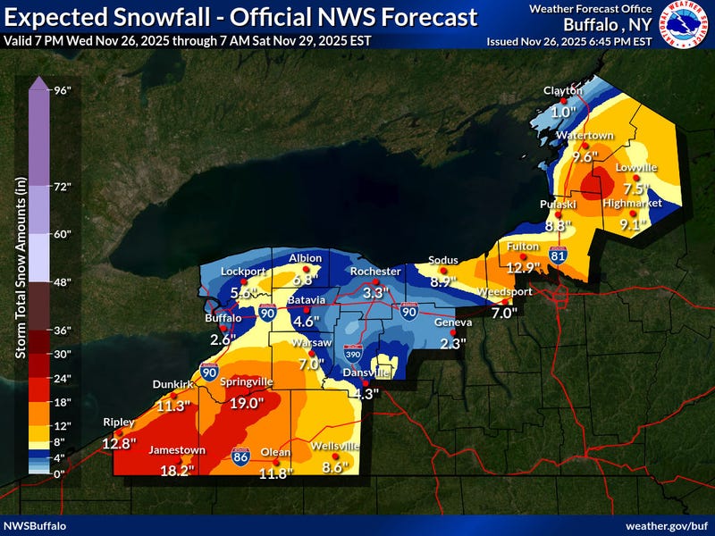
Due to the changeover from rain to snow, and the fact that the snow band is expected to quickly move southward, the significant snow totals that are grabbing much attention should be isolated well south of Buffalo, Reynolds tells WBEN.
"For the Buffalo metro area, we're not expecting too much. Anywhere from 2 to 4 inches, depending on how fast the lake effect band pushes through the city area."
Southward trek
NWS forecasters are quite confident that once the rain transitions to snow, it will only be a short period of time that it remains across the more populated Buffalo metro area. "Once it starts, we expect a couple of inches, but it's going to push south pretty quickly, and then by tomorrow morning, it will be south of the city."
The band of snow will be south of Buffalo by daybreak Thursday, and should be south of the more densely populated Southtowns by early to mid morning. From late morning Thursday through Thursday night, the heavy snow will focus across the higher terrain inland from the lake, including the Boston Hills, western Wyoming County, and the ridges of the western Southern Tier.
And more good news?
"Once it shifts to the south, it will primarily stay south of the city, and south of the southtowns and effect mainly the ski country."
Impressive southern tier accumulations possible
While the lake effect appears to be more likely a nuisance for the metro Buffalo area, the southern tier will be dealing with the potential of some impressive snow totals, forecasters warn.
"Anywhere from one, possibly up to two feet in some localized areas."
Buffalo AccuWeather Radar

WINTER WEATHER ADVISORY REMAINS IN EFFECT FROM 9 PM THIS EVENING TO 1 PM EST THURSDAY
* WHAT...Lake effect snow expected. Total snow accumulations 2 to 4 inches in the most persistent lake snows. Winds gusting as high as 55 mph will produce blowing and drifting snow.
* WHERE...Northern Erie and Genesee Counties.
* WHEN...From 9 PM this evening to 1 PM EST Thursday.
* IMPACTS...Plan on slushy and slippery road conditions and reduced visibility. The hazardous conditions will impact Thanksgiving holiday travel. Gusty winds will down tree branches and cause isolated power outages.
PRECAUTIONARY/PREPAREDNESS ACTIONS...
Lake effect snow will fall in relatively narrow bands. If traveling, be prepared for rapidly changing road conditions and visibilities.
WINTER WEATHER ADVISORY REMAINS IN EFFECT FROM 7 PM THIS EVENING TO 7 AM EST THURSDAY
* WHAT...Lake effect snow expected. Total snow accumulations 3 to 5 inches in the most persistent lake snows. Winds gusting as high as 55 mph will produce blowing and drifting snow.
* WHERE...Niagara and Orleans Counties.
* WHEN...From 7 PM this evening to 7 AM EST Thursday.
* IMPACTS...Plan on slushy and slippery road conditions with reduced visibility. The hazardous conditions will impact Thanksgiving holiday travel. Gusty winds will down tree branches and cause isolated power outages.
PRECAUTIONARY/PREPAREDNESS ACTIONS...
Lake effect snow will fall in relatively narrow bands. If traveling, be prepared for rapidly changing road conditions and visibilities.
WIND ADVISORY REMAINS IN EFFECT UNTIL 1 AM EST FRIDAY
* WHAT...Southwest winds 30 to 40 mph with gusts of 50 to 55 mph expected this afternoon through tonight. West winds 25 to 35 mph with gusts of 45 to 50 mph expected Thursday through Thursday night.
* WHERE...Erie, Niagara, Orleans, Genesee, Wyoming, and Chautauqua Counties.
* WHEN...Until 1 AM EST Friday.
* IMPACTS...Gusty winds will blow around unsecured objects. Tree limbs could be blown down and a few isolated power outages may result.
LAKESHORE FLOOD WARNING IN EFFECT UNTIL 10 AM EST THURSDAY
* WHAT...Lakeshore flooding expected.
* WHERE...Lake Erie shore of Erie and Chautauqua counties.
* WHEN...Until 10 AM EST Thursday.
* IMPACTS...The rapid rise in water levels at the eastern end of Lake Erie will result in lakeshore flooding along the Lake Erie shore. Flooding is likely along Route 5 in Hamburg, Buffalo Harbor and Canalside, Dunkirk Harbor, and other flood prone locations. Very high wave action will also result in shoreline erosion.
PRECAUTIONARY/PREPAREDNESS ACTIONS...
A Lakeshore Flood Warning means lakeshore flooding is occurring, is imminent, or is expected to occur. For your safety, stay off breakwaters, piers, rock outcroppings and beaches! Waves are often larger than they appear and can easily wash you away.
Expect significant beach erosion and debris, local road closures and extremely dangerous boating conditions.
LAKE EFFECT SNOW WARNING REMAINS IN EFFECT FROM 1 AM THURSDAY TO 1 AM EST SATURDAY
* WHAT...Heavy lake effect snow expected. Total snow accumulations 12 to 22 inches in the most persistent lake snows. Winds gusting as high as 50 mph will produce blowing and drifting snow.
* WHERE...Jefferson, Lewis, Wyoming, Chautauqua, Cattaraugus, and Southern Erie Counties. The greatest accumulations off Lake Erie will be found across the higher terrain of the Chautauqua Ridge, Boston Hills, and southwest Wyoming County. The greatest accumulations off Lake Ontario will be found across the Tug Hill Plateau.
* WHEN...From 1 AM Thursday to 1 AM EST Saturday.
* IMPACTS...Travel will be very difficult with deep snow cover on roads and poor visibility. The hazardous conditions will impact Thanksgiving holiday travel. Gusty winds will down tree branches and cause isolated power outages.
PRECAUTIONARY/PREPAREDNESS ACTIONS...
Heavy snow will fall in relatively narrow bands. If traveling, be prepared for rapidly changing road conditions and visibilities.