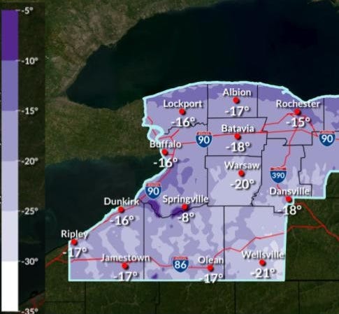

It is January in Buffalo, however the unrelenting cold conditions are below the averages and wearing on the Buffalo-Niagara region.
A frigid airmass will remain locked in place through the weekend, National Weather Service forecasters say.
"We've been cold here for the last week, and we've got an even colder air mass set to arrive upon us later today, and through the daytime on Friday," NWS meteorologist Dave Thomas tells WBEN.
A Cold Weather Advisory is posted for the entire Western New York region through Friday morning.
We will indeed be in the deep freeze overnight into Friday, with temperatures dipping below zero for most locations.
The wind chill readings will be what area school districts will be watching in making any possible decisions on school closures Friday. "We're looking at wind chills around negative 15 degrees across all of WNY," Thomas forecasts.
When the sun comes up Friday, don't look for temperatures to soar, by any stretch. "Tomorrow we're looking for highs only in the single digits, and it's actually been 7 years since we've had single digit highs."
As for the national weather headlines warning of a storm along the eastern portion of the nation, Thomas says, not to worry here in the Buffalo area.
"Nothing big," Thomas says.
COLD WEATHER ADVISORY IN EFFECT FROM 7 PM THIS EVENING TO 10 AM EST FRIDAY
* WHAT...Bitterly cold wind chills as low as 24 below zero expected.
* WHERE...All of Western New York. Coldest wind chill values expected inland from the eastern Great Lakes.
* WHEN...From 7 PM this evening to 10 AM EST Friday.
* IMPACTS...Bitterly cold wind chills as low as 24 below zero will cause frostbite on exposed skin in as little as 30 minutes.
Frostbite and hypothermia will occur if unprotected skin is exposed to these temperatures.
PRECAUTIONARY/PREPAREDNESS ACTIONS...
This is a potentially hazardous situation to be outdoors. If you must be outside, be sure to cover all exposed skin. Frostbite can occur in 30 minutes or less with apparent temperatures of 15 below zero or colder.